Walk #193: Beauly to Garve
 |
 |
|
General Data
| Date Walked | 28/04/2002 |
| County | Highlands |
| Start Location | Beauly |
| End Location | Garve |
| Start time | 09.12 |
| End time | 17.50 |
| Distance | 16.4 miles |
| Description | This was a walk of two halves, with a fairly ordinary road walk as far as Contin being followed by forestry tracks on the slopes above the River Garve and the Rogie Falls. |
| Pack | Full pack with five days food. |
| Condition | I have found today's walk to be fairly hard, and have suffered as a consequence. My knee did not really play up all day, but my bad ankle is aching which is a worrying sign. My back and shoulders are fine, with no rashes or redness on them. I do, however, have the first blister of the trip - a nasty little one on the ball of my right foot. |
| Weather | When I left the B&B there was a little drizzle in the air, but not enough to cause me to get my coat on, as my fleece was coping well with it. Later on near Marybank it began to rain harder so I took my fleece off and replaced it with my coat. After I had spent a couple of hours in the hotel bar in Contin it had stopped raining, so I set off again. During this last part of the journey it was mostly dry, but there were occasional bursts of drizzle. The wind was not very strong today but the temperature was also quite low. |
| OS map | Landranger number 26 (Inverness & Loch Ness) and [OSMap LR20] |
 |
 |
|
Map of the walk
Maps courtesy of Google Maps. Route for indicative purposes only, and may have been plotted after the walk. Please let me have comments on what you think of this new format. For a detailed table of timings for this walk, please see the table file.
 |
Notes
This was a long day that was hard on the feet, but was enjoyable nonetheless. The weather did it's best to put a literal damper on proceedings, but due to a handily-placed hotel it did not manage.
I wore two pairs of outer socks today so that I could see if it stopped the underside of my feet aching; it did not work, but I did end up with a blister on the ball of my right foot, which is the first significant blister of the trip so far. I will have to put a Compeed onto it in the morning to make the walk bearable.
This B&B is excellent, and I would recommend it to anyone. The owners are a charming couple and they have done everything they could to make me feel comfortable. The B&B is slightly outside the village to the north and I did not feel like walking to the hotel for a bite to eat, so the landlady was kind enough to make me some scrambled eggs which was washed down with a wee dram of whisky! Such kindness deserves to be rewarded.
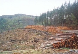
The river that runs from Loch Garve to Contin is fairly spectacular, and recent tree felling had left it visible from the forestry tracks that I was using. it consisted of a series of rapids, and the whole setting was quite picturesque, especially the section around Rogie Falls. I did not go down to look at these in ore detail because I was tired and wanted to reach he B&B, but from a distance I could see that for someone less tired it would be well worth it.
When I got to Contin I was feeling slightly tired as I had not yet had a rest, and so I asked if there was a pub anywhere. A lady serving in a petrol station pointed uphill towards the Coul House Hotel. I climbed the long drive with slight trepidation, as my coat was soaked and I looked wet and bedraggled. Fortunately they let me into the Kitchen Bar, where I was warmly welcomed and had a toasted sandwich and a couple of pints. I then realised that it was about time for the Grand Prix to start, so I asked if the television put onto ITV so that I could watch it. They readily agreed, and iI stayed there until the end of the Grand Prix. Whilst I was there I phoned up a B&B in Garve and get accommodation for tonight. This meant that today was about fifteen miles, which is a good distance for such a wet day.
The rain was really depressing, particularly when it became continuous. I set off with my fleece on and no coat because there was just a light drizzle, and I managed to stop putting my coat on until about two hours into the walk when the rain became much harder. Luckily by the time I had watched the grand prix in the pub the rain had abated somewhat, so the final part of the walk was considerably drier, although muddier as it went over forest tracks.
Moy Bridge, about a mile and a half Southeast of Contin, was a peculiar single-track road bridge. The road that leads to it from Marybank had barriers that could be shut in times of flood, so I assume that the River Conon can severely flood. The signs also warned pedestrians that the water levels rise quickly, although I doubt that they would rise so quickly that someone could not out walk them. I have not seen this sort of barrier before so I found it quite interesting, which could be a sign of how boring I am!
I passed the Bridge of Ord distillery, and I got a strong whiff of whisky in the air which was really nice. Later on at the B&B I was told that the whisky produced there is fantastic, so I am slightly annoyed that I did not get the opportunity to go in.
I am unsure about what to do next; the route seems fairly obvious - walk along the A835(T) to Black Bridge and then head north along tracks to wild camp somewhere near Loch Vaich. However I really do not have much enthusiasm to do it - my ankle hurts and the weather forecast is for some very bad weather which I would rather not be camping out in. I will wait to see how I feel in the morning, but spending an extra night here does have it's appeal. Alternatively I could walk along the A835(T) to the Aultguish Inn about two miles to the west of Black Bridge and spend the night there.
Whilst walking into Contin I met a bedraggled man and woman walking in the opposite direction. They had packs on, so I assumed that they were walking and so I decided to ask them about the road ahead. hey said that they had walked from Gave, and that there were forestry tracks all the way there which would avoid yet more road walking. The locals in the hotel confirmed that and told me that it was a far better route than the road one.
Directions
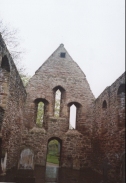
This walk starts off on the pavement on the A862 in Beauly. Head north along the road past the ruins of the priory to the outskirts of the village. Continue along the pavement northwards for three miles until Muir of Ord is reached.
When a junction is reached turn left along the A832 and follow it across a bridge over the railway station. At another junction continue straight on along the A832.
Follow the A832 as it passes the Glen of Ord Distillery. Here the pavement ends and the road has to be followed, but fortunately the road is not too busy. The road turns to the Northwest for a couple of miles until a bridge over the Rive Orrin is reached.
Here the road turns to the left and head along a straight stretch of road for a couple of kilometres to the little village of Marybank. Follow the road it turns to the right and descends downhill to the north. Pass gates that can close to shut the road in times of flood and walk for a kilometre to Moy Bridge. Take care crossing this bridge, as it is very narrow and long.
On the north side of the bridge climb up a slight slope to a T-junction with the A835(T) road. Turn left and follow this road westwards along the northern bank of the river. This road is busier than the previous ones, but it is also wide and has big grass verges which can be walked on or stepped onto when traffic passes.
On the southern outskirts of Contin a junction with the A834 is reached. Continue straight on northwards into Contin. As you pass through Contin a road heads up hill to the right with houses on each side. Take this road as it angles uphill. When the surfaced road bends slightly to the left continue on uphill into some woodland by means of a well-worn and wide path. This path shortly ends at a U bend in a large forestry track.
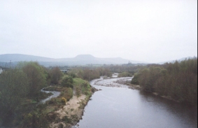
Continue straight on uphill along the track and follow it as it rises up to a junction. All track junctions in the forest are signed, so route-finding is simply a case of following the signs for Garve. The track soon descends to meet the river and eventually the farm at Rogie. Continue on to the Northwest and then west, passing under the railway line before rising up the hillside into a large loop which due to the cutting down of the woodland gave good views of Loch Garve.
The track then starts to descend along a much rougher and muddier track along the northeaster bank of Loch Garve. Just before a large stream is reached a new large metal gate in a deer fence blocks the way. There is a wooden gate beside the gate which was tied up. Go through he gate and splash through the stream before continuing the descent.
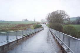
When the track reaches a hairpin by a gate open the gate and walk through. Pass under Strathgarve Lodge and continue until a surfaced road is reached. At a junction turn left to head north-southwestward's for about a kilometre to a bridge over a river and then the railway station. Cross over the railway using the very attractive metal footbridge and exit the station onto the A835(T) road. Turn right and head over the angled level crossing and head north past the hotel. The B&B that I stayed in is about a kilometre north of the station, just before the junction with the A832 road.
Distances
| From | To | Distance (m) | Ascent (ft) | Descent (ft) |
|---|---|---|---|---|
| Beauly | Muir of Ord | 2.4 | 125 | 7 |
| Muir of Ord | Contin | 6.7 | 223 | 246 |
| Contin | Garve | 7.3 | 879 | 728 |
This makes a total distance of 16.4 miles, with 1228 feet of ascent and 981 feet of descent.
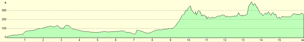
For more information on profiles, ascents and descents, see this page
Accommodation
IĀstayed at Hazelbrae House, Garve, Ross-Shire, IV23 2PX, telephone (01997) 414382. It cost seventeen pounds for the room, but I paid a little more as I had an evening meal. This was a truly excellent B&B and the couple owning it made me feel incredibly welcome. This B&B would make an excellent place to stay to take advantage of all the local munros, and the couple who run it are very walker-friendly.
Disclaimer
Please note that I take no responsibility for anything that may happen when following these directions. If you intend to follow this route, then please use the relevant maps and check the route out before you go out. As always when walking, use common sense and you should be fine.
If you find any information on any of these routes that is inaccurate, or you wish to add anything, then please email me.
All images on this site are © of the author. Any reproduction, retransmissions, or republication of all or part of any document found on this site is expressly prohibited, unless the author has explicitly granted its prior written consent to so reproduce, retransmit, or republish the material. All other rights reserved.
Although this site includes links providing convenient direct access to other Internet sites, I do not endorse, approve, certify or make warranties or representations as to the accuracy of the information on these sites.
And finally, enjoy your walking!
This walk was mentioned in the following routes:
| My sectional Land's End to John O'Groats walk |
Nearby walks
| # | Title | Walk length (miles) |
|---|---|---|
| 192 | Lewiston to Beauly | 14.7 |
| 194 | Garve to Aultguish Inn | 9.2 |
| 539 | Arabella to Dingwall | 22.8 |
|
|

|