Walk #311: Milford on Sea to Southbourne
 |
 |
|
General Data
| Date Walked | 29/12/2002 |
| County | Hampshire, Dorset |
| Start Location | Milford on Sea |
| End Location | Southbourne |
| Start time | 08.53 |
| End time | 15.07 |
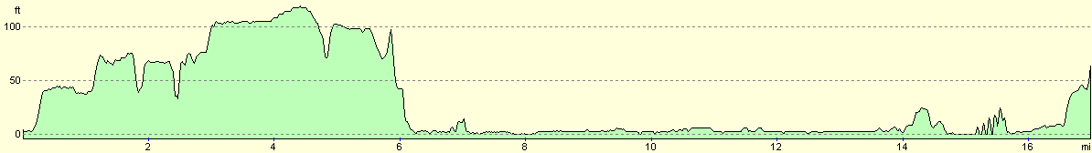
| Distance | 16.9 miles |
| Description | This was a nice walk up to and around Christchurch Harbour, and also taking in Hengistbury Head. |
| Pack | Today I carried my 30-litre Karrimor HotRock rucksack, which was filled with my packed lunch, waterproof leggings, water bottle and a couple of spare shirts, together with the usual assortment of odds and ends. |
| Condition | I feel fairly fatigued after this walk, which could be due to the fact that I was battling against a headwind for most of the day. This slowly wore me out, particularly when having to deal with gusts that blew from slightly different angles making it hard to keep my footing. My ankle was absolutely fine today, and I had no problems with any other parts of my body. |
| Weather | There was some heavy rain overnight that woke me several times as it drummed away on the top of the roof a few inches from my head. In the morning this had not let up, so I wrapped up well before I ventured out of the van. In the end the rain, which varied from drizzle to heavy rain, was not the thing that annoyed me most about the day; the wind was at times quite ferocious and to make matters worse it was for much of the day a headwind, which made matters interesting on the clifftops. It was quite a mild day, and this prevented me from getting chilled despite the rain. |
| OS map | Landranger number 195 (Bournemouth & Purbeck, Wimborne Minster & Ringwood) |
 |
 |
|
 |
 |
|
Map of the walk
Maps courtesy of Google Maps. Route for indicative purposes only, and may have been plotted after the walk. Please let me have comments on what you think of this new format. For a detailed table of timings for this walk, please see the table file.
 |
Notes
The weather really spoilt this walk, and was dramatically different to yesterdays. This was annoying as today was far more scenic than yesterday, the section around Hurst Castle being an exception to that rule. Despite the weather I still quite enjoyed the days walk, although it would have been far more enjoyable in better weather. The forecast for tomorrow is for more of the same, so I shall have to be prepared to get wet once again.
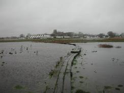
Whilst trying to walk from the beach into Christchurch I decided to follow the looping footpath across Stanpit Marshes. The first part of the is footpath was fine, but I decided to turn off it down another footpath that emerges near the priory in the town. The first part of this path was over boggy fields, and although a couple of the larger patches of water had plank bridges over them the ground had eroded away in front of the bridges so that I had to jump onto the bridge. A stile was in a similar state, and when I got to the other side I was faced with a causeway consisting of three planks side by side winding away into the distance. All around the causeway there was a mixture of water and grass where the field had flooded with all the recent rain, so I carefully set off along the wooden planks. The first problem was that they were quite slippy, but my walking poles helped keep me on the straight and narrow. Unfortunately I then came across a place where two lengths of planks had been removed, so I had to walk across a patch of ankle-deep waterlogged grass to get to the rest of the causeway. I then followed it on, but after another couple of minutes I realised that the causeway itself disappeared under the water as it approached the river and I could not see where it came out. I then decided that it would be stupid to continue on, so I had to retrace my route back along the causeway to the original path and take a longer route around. I found this quite annoying, but the causeway disappearing into the water did make a quite interesting sight.
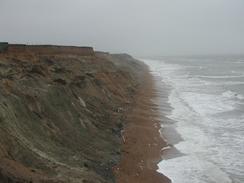
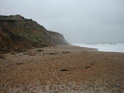
Hengistbury Head was very impressive, and when I got to it I was faced with a choice of whether to walk around the headland, or walk up to the viewpoint on the top of the head, or just to turn away and walk straight into Bournemouth. In the end I decided to walk around it as that would give me the longest route, and it could also be done without doubling back on myself. The first part of the walk around the northern side of the headland was relatively easy as there is a surfaced track along which a road train runs (and indeed came near to running me over as I had not been expecting it), but the southern side was harder as I had to walk along the shingle beach below the high cliffs with the tide coming quite close to the base of the cliffs. Whilst walking this latter section I thought that the cliffs looked a strange shape; it turns out that they were quarried for twenty-five years in the nineteenth century. Hengistbury Head is a very historic place; the Double Dykes are ancient earthworks and thousands of Celtic coins have been found in the area, including a haul of 3,000 coins found below a second century roundhouse. It is yet another place that I would not mind visiting again for a closer look in the future, and I am annoyed that I could not explore it today in better weather.
As of today I have completed 1,510.2 miles, which means that I have broken the 1,500 mile barrier. This gives me an enormous sense of satisfaction, as it is the equivalent of doing my sectional Land's End to John O'Groats walk in one go. Since this trip is meant to be a total of 5,500 miles in length that should mean that I have under 4,000 miles still to go, but the current total is about 5,540 miles, which means that I still have a few days to go before I get under 4,000 miles remaining. Looking back on the walk so far is quite difficult - it is all such a blur, and I find it amazing to think of all the places that I have been to so far on the trip. The time has literally flown by, and a week seems to pass in virtually no time. Some of the individual walks can drag on, so I fell like they have taken days, but looking back I feel like I have only been away for a couple of weeks rather than nearly three months. I have always thought that when walking time becomes a geographical metric - you refer to where you were at a particular time rather than by its date. This has been less visible on this walk as I have the campervan and TV to give me an impression of the passing of the days, but nonetheless I still refer to 'when I was in Southampton' instead of 'last Wednesday'.
Directions
This walk starts off at a car park beside the sea in Milford on Sea. If the tide is low it should be possible to walk along the shingle beach all the way to Little Haven at the mouth of Christchurch Harbour. Note that there are some significant distances between access points up the cliff, so care should be taken. If the tide is high or you do not fancy a long walk on the shingle, take the route on the cliffs described here. From the car park face the sea and turn right along a little promenade westwards through the town.
The promenade ends fairly soon and the path climbs uphill along Hordle Cliff. The path continues on, passing a trig point before skirting the edge of a golf course. When a steep-sided valley is reached the map shows the footpath leading off to the right along the side of a valley called Beckton Bunny; however there is another footpath (not marked on my OS map) that heads across the valley on a bridge before skirting the cliffs and reaching Barton on Sea.
In Barton on Sea I joined a road that follows the top of the cliffs westwards. Unfortunately when the road reaches the western side of the town it meets a caravan park and curves around to the right to head northwards up to the A337 road as you cannot walk through the caravan park. When the A337 is met turn left and descend downhill to a bridge over Chewton Bundy, which marks the Hampshire / Dorset boundary.
On the other side of the bridge a footpath leads off to the left to head about a kilometer southwestwards back to the top of the cliffs. However when I first walked this route the footpath was closed due to a landslip, so I had to walk along to the first road on the left and follow this until a road leads off to the right. Naturally enough, it had reopened the second time I walked it seven years later! Follow this road and then turn left to reach a car park on top of the cliffs.
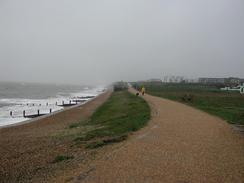
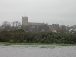
If the tide is out descend onto the beach and walked past a series of groynes westwards beneath the cliffs under Highhcliffe Castle. If the tide is high you can follow footpaths that follow the clifftop before skirting around the castle. Whichever route you take, follow the cliffs around as they slowly lower in height as they enter Christchurch and go around to Lower Haven by the lifeboat station. Follow the road around the point until it ends at a road and then take this road westwards through Stanpit.
After about a mile take a footpath that leads off to the left and follow it as it curves around the Stanpit Marsh Nature Reserve. As this path heads northwards another footpath heads of to the left, but this path was impassable due to flooding so I continued straight on along the original footpath that headed north before reaching a road next to a leisure centre.
Walk on along this road until a larger road is reached. Turn left along this road and follow it westwards as it crosses two river bridges and passes the castle. When the road curves around to the right continue straight on down another road that curves around and ends at another road.
Turn left down this road and follow it for a short distance until it ends at a T-junction with the B3059 road. Turn left and cross the river on the bridge. On the other, western, side of the bridge take a footpath that heads off to the left and follows the southern side of the river before heading southeastwards through a nature reserve until a tarmac track is reached to the west of Hengistbury Head.
Turn left along the tarmac track and follow it around to the north of the large hill. When the eastern side of the Head is reached the track turns to the left to head up to the point and here you have a choice. If the tide is out that you can walk along the beach under the cliffs to the south of the hill, or you can take a footpath that head up over the hill. Only take the footpath under the cliffs if the tide is well out, however, or the tide could trap you.
Both of these routes meet beside the beach on the western side of the hill. From here follow a footpath that heads alongside the beach westwards into Southbourne. The footpath meets a road near a car park on the eastern side of the town, and I met Sam about a kilometre west along this road on the top of the cliffs, where this walk therefore ends.
Distances
| From | To | Distance (m) | Ascent (ft) | Descent (ft) |
|---|---|---|---|---|
| Milford on Sea | Christchurch | 8.1 | 364 | 367 |
| Christchurch | Southbourne | 8.8 | 295 | 230 |
This makes a total distance of 16.9 miles, with 659 feet of ascent and 597 feet of descent.
For more information on profiles, ascents and descents, see this page
Accommodation
We stayed at Lost Pines, 53 Wayside Road, St Leonards, Ringwood, Hampshire, BH24 2SJ. This site cost us seven pounds for the night, and was annoying as the male toilets and shower did not have a light in, which meant that I had to have a shower in the van.
Disclaimer
Please note that I take no responsibility for anything that may happen when following these directions. If you intend to follow this route, then please use the relevant maps and check the route out before you go out. As always when walking, use common sense and you should be fine.
If you find any information on any of these routes that is inaccurate, or you wish to add anything, then please email me.
All images on this site are © of the author. Any reproduction, retransmissions, or republication of all or part of any document found on this site is expressly prohibited, unless the author has explicitly granted its prior written consent to so reproduce, retransmit, or republish the material. All other rights reserved.
Although this site includes links providing convenient direct access to other Internet sites, I do not endorse, approve, certify or make warranties or representations as to the accuracy of the information on these sites.
And finally, enjoy your walking!
This walk was mentioned in the following routes:
| My walk around the coastline of Britain |
Nearby walks
| # | Title | Walk length (miles) |
|---|---|---|
| 310 | Bucklers Hard to Milford on Sea | 19.0 |
| 312 | Southbourne to Hamworthy Station | 15.3 |
| 801 | A circular walk from Brockenhurst to Burley | 23.5 |
|
|

|