Walk #319: West Bexington to Lyme Regis
 |
 |
|
General Data
| Date Walked | 07/01/2003 |
| County | Dorset |
| Start Location | West Bexington |
| End Location | Lyme Regis |
| Start time | 08.05 |
| End time | 15.41 |
| Distance | 15.5 miles |
| Description | This was a lovely and scenic coastal walk, taking in the highest point on the South Coast of England, Golden Cap. |
| Pack | Today I carried my 30-litre Karrimor HotRock rucksack, which was filled with my packed lunch, waterproof leggings, water bottle and a couple of spare shirts, together with the usual assortment of odds and ends. |
| Condition | I feel absolutely fine after this walk, and have no problems to report. Yet again my ankle has not played up, and my feet are absolutely fine. |
| Weather | Today was another bitterly cold day, and in the wind it was even more so. To add to this there were occasional snow flurries that created a sort of winter wonderland effect. In between the showers there was some sunshine, which made the hills with their light scattering of snow look sublime. |
| OS map | Landranger number 194 (Dorchester & Weymouth, Cerne Abbas & Bere Regis) and Landranger number 193 (Taunton & Lyme Regis, Chard & Bridport) |
 |
 |
|
 |
 |
|
Map of the walk
Maps courtesy of Google Maps. Route for indicative purposes only, and may have been plotted after the walk. Please let me have comments on what you think of this new format. For a detailed table of timings for this walk, please see the table file.
 |
 |
|
Notes
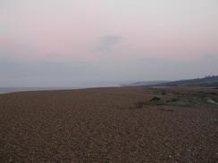
This walk started with a walk along Cogden Beach, which is the westernmost end of Chesil Beach. The walk along the shingle was quite hard, and I could not follow the easier path on the inland side of the shingle beach as it had flooded with all the recent rain. The beach soon ended, and cliffs took over for the rest of the day, which made for a lovely contrast. The paths on the clifftops were also easier than the shingle to walk along.
I stopped off at the very pleasant Anchor Inn in Seatown so that I could have a pint and relax for a few minutes before starting the climb up Golden Cap. In the pub I chatted to a lovely family who were out walking their dog, which was taking great interest in the pub cat who was sleeping on a bench. They gave me a donation for the charity that was gratefully received, and as a result of this chat I spent longer in he pub that I had been intending. The pub has a website at www.theanchorinn.co.uk.
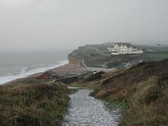
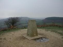
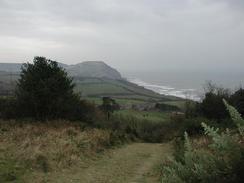
I found the climb up to the top of Golden Cap, The highest point on the south coast of England, to be fairly easy but when I reached the trig point at the top it started to snow. This made the top an unpleasant place to be, but at the top I met a man who was even better wrapped up then I was. I started chatting to him, and it turned out that his wife's ashes were scattered at the top of the hill, and he visited regularly. He pointed out some flowers that he had planted just below the summit in memory of his wife, and their colourful display looked superb in the snow. Just off the summit I met a Canadian gentleman who was climbing up using a piece of wood as a staff, and he asked me to take a photograph of him to prove that he had made it up to the top.
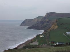
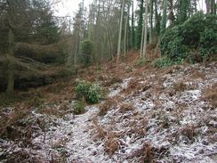
It snowed occasionally for most of the day, and this made the walk quite interesting, although it was not snowing hard enough to make me worried. The hills looked sublime with the little scattering of snow over them, particularly when the sun's rays caught them. The frozen ground made the going easier as the mud, which was widespread in places, had frozen solid.
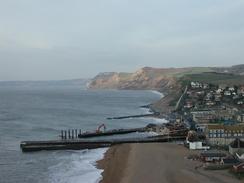
One annoying thing about today was that the coast path is diverted away from the coast on either side of Charmouth, leading to much road walking with few views of the sea. The diversions are long-standing ones and were made as the original coast path has been closed due to landslips. The diversions were not very interesting, and I wish that a more coastal route was available to walk along. This short stretch was by far the worst bit of the South West Coast Path so far, and I wish that all the road walking were not necessary.
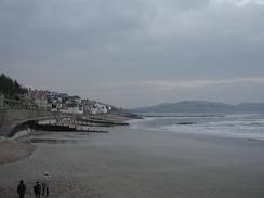
Lyme Regis is quite a pretty and historic little town, and I enjoyed my little stroll through it. There are lots of pretty little houses, and the large stone breakwater called the Cobb, behind which fishing boats are protected from the worst ravages that the sea can throw at them, dominates the seafront. I did not get much of an opportunity to look around the town, but I liked what I did see of it. All the streets seem to be narrow - ridiculously so in places - and the streets around the seafront are littered with more of the same little houses. I met Sam at the car park at Monmouth Beach, which is immediately to the east of the Cobb.
Directions
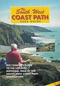
| During this walk I followed the South West Coast Path, the route of which is detailed in the Ordnance Survey National Trail Guide 11, Exmouth to Poole (ISBN 1-854109-88-X). Unfortunately the route description is written in reverse to the direction that I am walking, but the 1:25,000 maps in the book are clear and the signs on the ground are very good. Also to be recommended is the South West Coast Path Association guidebook (ISBN 0-907055-04-4), which has less concise directions and no maps but does include accommodation details and grades each section of the walk according to difficulty. They also publish reverse directions, which are suitable for walking in the direction that I walked the route. They have a website at www.swcp.org.uk, which is well worth a visit. | 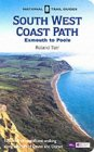
|
| 
| |
| |
| |
Distances
| From | To | Distance (m) | Ascent (ft) | Descent (ft) |
|---|---|---|---|---|
| West Bexington | West Bay | 5.4 | 945 | 968 |
| West Bay | Charmouth | 7.2 | 2293 | 2211 |
| Charmouth | Lyme Regis | 2.9 | 558 | 640 |
This makes a total distance of 15.5 miles, with 3796 feet of ascent and 3819 feet of descent.
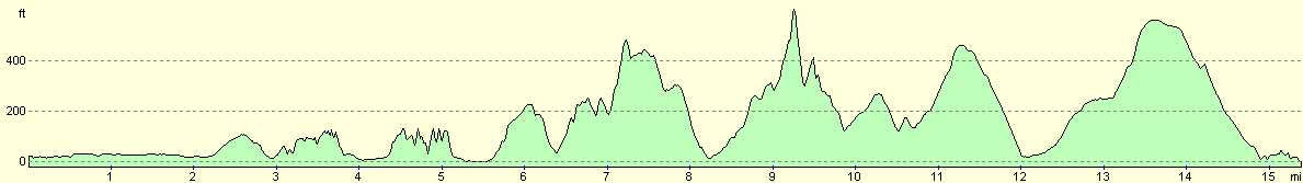
For more information on profiles, ascents and descents, see this page
Accommodation
We stayed at the Manor Farm Holiday Centre, Charmouth, Bridport, Dorset DT6 6QL. They can be contacted on 01297 560226 or on the web at www.manorfarmholidaycentre.co.uk. This site was reasonable, except for the fact that the shower block was out of commission due to the freezing weather, which is forgivable. It did not bother us too much as we had showers in the van, which was probably better than walking through the freezing outside air to the shower block. The site is virtually directly on the coast path (which we could not take advantage of as I walked on a few miles further to Lyme Regis), and cost ten pounds for the night.
Disclaimer
Please note that I take no responsibility for anything that may happen when following these directions. If you intend to follow this route, then please use the relevant maps and check the route out before you go out. As always when walking, use common sense and you should be fine.
If you find any information on any of these routes that is inaccurate, or you wish to add anything, then please email me.
All images on this site are © of the author. Any reproduction, retransmissions, or republication of all or part of any document found on this site is expressly prohibited, unless the author has explicitly granted its prior written consent to so reproduce, retransmit, or republish the material. All other rights reserved.
Although this site includes links providing convenient direct access to other Internet sites, I do not endorse, approve, certify or make warranties or representations as to the accuracy of the information on these sites.
And finally, enjoy your walking!
This walk was mentioned in the following routes:
| My walk around the coastline of Britain |
| South West Coast Path |
Nearby walks
| # | Title | Walk length (miles) |
|---|---|---|
| 318 | Wyke Regis to West Bexington | 14.3 |
| 320 | Lyme Regis to Sidmouth | 16.0 |
| 815 | A circular walk from Weymouth to Langton Herring | 17.6 |
|
|

|