Walk #793: Brockenhurst to Romsey
 |
 |
|
General Data
| Date Walked | 02/11/2007 |
| County | Hampshire |
| Start Location | Brockenhurst station |
| End Location | Romsey station |
| Start time | 07.20 |
| End time | 15.56 |
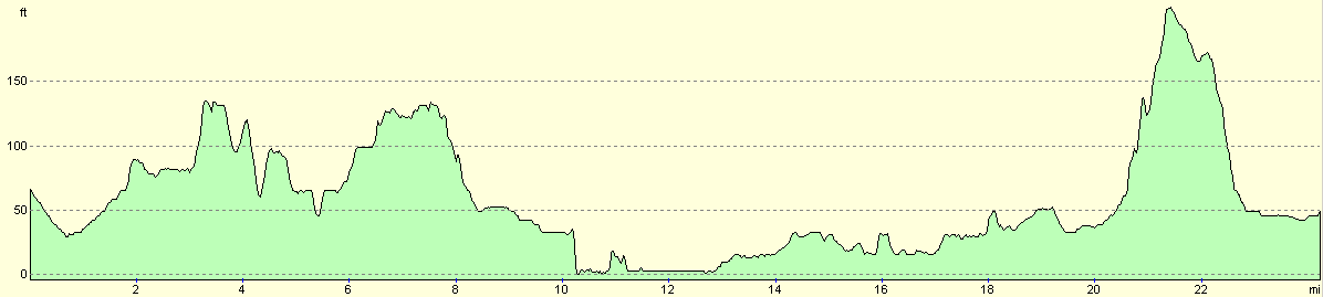
| Distance | 24.0 miles |
| Description | This is a walk of two halves; a stroll through the northeastern part of the New Forest was followed by the first eleven miles of the test way northwards, befpre looping around the northern side of Romsey. |
| Pack | Today I carried my 30-litre Karrimor rucksack, filled with waterproofs, a book and other odds and ends. |
| Condition | I feel absolutely fine after this walk. |
| Weather | Today was a very warm day for the time of year, with not much breeze to cool me down. The early cloud soon disappreared, leaving a day that was mostly sunny. |
| OS map | Landranger number 196 (The Solent & The Isle of Wight, Southampton & Portsmouth) and Landranger number 185 (Winchester & Basingstoke, Andover & Romsey) |
 |
 |
|
 |
 |
|
Map of the walk
Maps courtesy of Google Maps. Route for indicative purposes only, and may have been plotted after the walk. Please let me have comments on what you think of this new format. For a detailed table of timings for this walk, please see the table file.
 |
 |
|
 |
 |
|
Notes
I have a plan to walk the entire Test Way, and still have the southern few miles between the start in Totton to Romsey to complete. This is too short to do as an entire walk, even in a there-and-back way. For this reason I deicded to extend it by starting at Brockenhurst in the New Forest. This is the first time that I have walked in the New Forest since my coastwalk five years ago. As it is an end-to-end walk I got the train down, which was not a particularly quick method, especially as I was keen to get started.
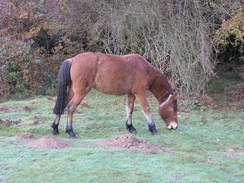
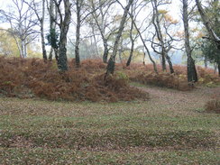
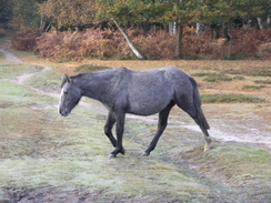
It was still slightly dark as I set off north along the A337, which bisects the town. I stopped off at a newsagents to buy some provisions from a friendly shopkeeper, then continued on. Just after a hotel on the right I turned right along a path that headed northeast across Balmer Lawn, plank bridges haoping me across a couple of streams. A few New Forest ponies were around, none of whom appeared to pay much attention to me.
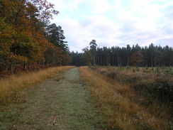
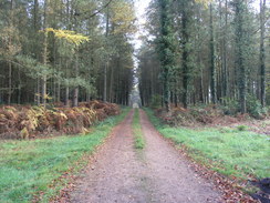
The path joined a cycle path as it headed through Pignal and Parkhill Inclosures, the going being easy and very enjoyable. This was a different form of walking; very enjoyable desite the views being limited by the trees. It was true woodland walking (albeit on a good-quality track), and was about as far away from the wearying monotony of walking through coniferous woodland as it is possible to get. It was really enjoyable, although the going soon became harder as I bypassed the tracks and followed paths to join the B3056 road near a caravan park.
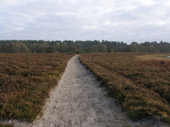
I followed the road for a short distance before striking out once more along a path that headed northeastwards through trees and then across heathland, just to the north of the worryingly-named Matley Bog. In reality it was a wonderful stroll with many ponies around. I was in heaven, really enjoying myself as I walked. A bridge took me over a railway line near the Fulliford Bog, and another good track took mo onwards in a gap between two inclosures. Although not quite as enjoyable as the previous stretch, this was still fun, and it felt a shame when the track dumped me out at a car park on a road near the New Forest Otter, Owl & Wildlife Park (I visited this a year later with my nieces, and it is well worth a visit if you like furry critters).
More tracks took me northeastwards towards Langley Lodge; these tracks were not public rights of way, and before the lodge was reached I turned right down another track. This took me onwards through more trees around Herons Hill and Yards Hill. There was a trig pillar somewhere in the trees off to my right, but I did not feel like scrambling around trying to find it so early on in the walk.
The track eventually emerged at a road, which I followed to the A326 at Pokesgreen. The road was busy and it took me a while to cross; on the other side I turned left and started following a minor road that skirted the road past the outskirts of Marchwood. The noise of the main road was intrusive, and it was a relief when it curved away, crossing the freight-only railway line to Fawley Refinery on the way.
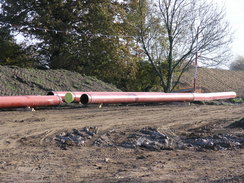
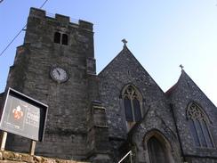
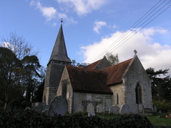
Shortly after this I had planned to take a footpath that cut off a stretch of road walking; unfortunately, signs said that the footpath was closed. Disappointed, I trudged along the quiet road and soon came across the reason for the closure. A gas pipeline was being constructed across the road; pipes were laid out along the giant scar, and although the ground was churned up by vehicles there was no-one about. I had come across similar works to the north of Romsey, which I assume is part of the same work. Fortunately the road was open, and I strolled on along roads through Eling to reach the pretty Eling Church, situated right on the top of a hill.
The road headed downhill to reach the toll bridge over a creek at Eling. I had last been here on my coastwalk, and it was nice to be back. On the other side of the bridge is an old tidal mill, one of a few in the world still grinding corn. Eling marks the start of the Test Way, but there were no signs stating the starting point. A fingerpost opposite the pub pointed off in the right direction, and beyond this was a fenced area containing storage containers at Eling Wharf.
It is a pleasant area; the creek is always filled with pleasure boats, ropework on their sails clanking noisily against their masts. I strolled on, following a path that ran along the northern bank of the creek. Initially this followed a path jammed between a road and the water, but it is a pleasant walk nonetheless. When the road ends the path continued on, soon reaching a bridge over the creek. There were no signs showing which way to go, so I crossed over and followed a path. This soon ended at the A326, and it was obvious that I had gone wrong.
Instead of heading back I turned right and walked along the wide verge of the noisy A326 to reach a large roundabout. At this I followed a dual carriageway for a short distance to reach Rum Bridge over the creek. Some pedestrian lights took me across the road, and on the other side a footpath took me northwards alongside the creek, now really a river. Considering that this is in the middle of the town of Totton, it was a surprisingly pleasurable walk.
Soon a bridge over the river was reached, and this took me to a larger bridge that crosses a railway line. This dumped me unceremoniously into the middle of the town, and I followed a series of markers on lampposts, keen to get back into the countryside. A long road took me north, before the Test Way joined a footpath that crossed a tributary of the river.
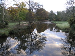
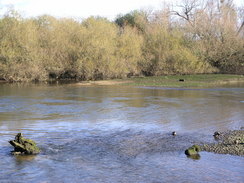
What followed was a very pleasant stroll through the Lower Test Nature Reserve, low-lying ground that is naturally boggy. Stretches of boardwalk took me across the worst parts, along with other footbridges over other streams of the river. I took my time, enjoying being out into the wilds once more. Even then civilisation was very obvious; to the south the high cranes of Southampton container port stood sentinel.
Further paths took me on northwards; at one point there was a depression off to my right, which looked suspiciously as though it may have been part of the long-disused Andover Canal, which ran northwards from the Test at Redbridge near Totton to Andover. Much of the route of the canal was obliterated when a railway line was constructed, and it is sometimes hard to trace the remaining disconnected parts.
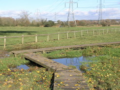
A road was joined for a short distance before another path took me northwards. Nursling Church was only a short distance away, but the M3 was in the way. To get over this a diversion was needed, and this involved walking down a narrow, overgrown path that squeezed between the motorway on the left and a fence on the right. It was hardly a salubrious stretch of the walk. I was thankful when the path ended at a minor road, which finally took me under the motorway.
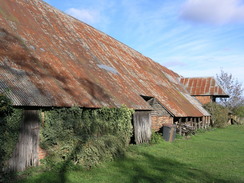
On the other side a road took me back to Nursling Church. From here, a track took me northwards. The river was only a short distance away to the left, but it was never in sight. At Longbridge Farm a bridge took me across the river, and for the first time today I was heading in a southwesterly direction. The track took me on across the floodplain, eventually reaching the farm at Moorcourt, where a lovely rustic barn with a low corrugated iron roof.
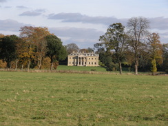
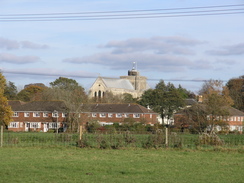
A long track path took me northwards along the floodplain. There was not much to note until the frontage of Broadlands House became visible to the right. It is a spectacular building, and was the home of the Mountbatten family. To the north the low, squat roofline of Romsey Abbey became visible.
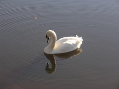
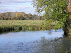
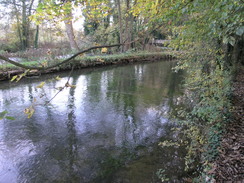
The footpath ended at the A27 road. The Test Way took me down towards Romsey. Here I could have walked into town and back to my car, but I felt like walking on further. When I reached the road bridge over the river, I turned left and followed a track alongside the river. It is a lovely spot, complete with swans swimming around on the crystal-clear water. A little further on was Saddler's Mill, one of the few remaining mills on the river in the village.
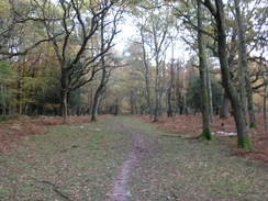
From Saddlers Mill the path heads across the floodplain, and although the river is not too far away is well out of view. I had walked this recently, and knew the route well. Unfortunately I was now well of my Ordnance Survey map, so I was having to go by memory. The walk through Squabb Wood was enjoyable; dark, but with a pleasant coating of leaves underfoot. Just to the north is Roke Manor, which now houses a technology firm.
It was starting to get late, so when I reached a lane I turned right, leaving the Test Way. I had never driven or walked along this lane before, and there were no signposts to indicate the right way. It was fairly obvious, however, that heading eastwards would take me towards a main road. The lane passed the entrance to Roke Manor, and fortunately it was not too busy. The lane ended at the B3084, which almost immediately crossed over a railway line. By this point I was getting slightly nervous as I was slightly unsure whether I was heading in the right direction, and I did not want to be waling along main roads in the dark.
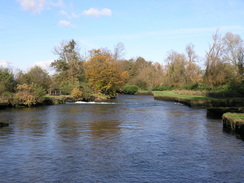
The B3084 ended at a junction with the A3057, which runs north from Romsey. I felt slightly better now, as this was a road I had driven along on a few occasions. The part of the road beside the pub is narrow, and so I decided to follow a footpath that led off beside the pub. I had no idea where it would head, but it seemed preferable to the road. It soon met the River Test, and I was thankful when it turned to the right to head southwards along the riverbank. It was a very pleasant stretch, although the path was a little narrow in places.
The path ended all too soon at Great Bridge, and I was deposited back onto the main road. Fortunately the road south from the bridge is very straight, and was not too bad a walk. By this stage I was getting fairly tired, and it was a relief when the outskirts of Romsey came into sight. I passed under a railway bridge and then turned down a familiar road that led to the railway station, where I had left my car to catch the train. It had been a very interesting walk and varied walk, although the last few miles could easily have been lopped off.
 |
 |
|
 |
 |
|
Directions
This walk starts off from Brockenhurst station. Leave the station and walk down the approach road to reach the A337 road. Turn left, to start heading north for 0.9 miles, passing the junction of the B3055 road and then a hotel on the right. Immediately after the hotel turn right, to join a track that heads to the south of a campsite. The track ends, and a path continues on northeastwards, crossing a boggy area of land called Balmer Lawn and a couple of simple plank bridges before reaching the trees at Pignal Inclosure near SU311038. A track starts in the trees; follow this northeastwards for a few hundred yards, before it turns slightly to the left to take a more northerly course through the trees.
It soon curves to the right once more, and heads northeastwards through Parkhill Inclosure. At SU330058 a path leads off to the left, following a fence slightly east of northwards for over half a mile, eventually joining a track near a campsite. Shortly after this the track ends at the B3056 road. Turn left to follow the road northwards past Matley Bog, and at a car park on the right turn right to start following a path northeastwards through Matley Wood. The path emerges from the wood, and a path continues on across Matley Holms, descending slightly to cross a stream before reaching a bridge over a railway line.
Cross the bridge, and on the other side head northeastwards along a path for a mile; it passes a car park and then ends at a road. Turn right along this road for a quarter-mile, and then turn left along a track at SU356095, opposite The Homestead. Note that this section is not a public right-of-way. Follow the track northeastwards for a little under half a mile until a crossroads is reached in the track near Langley lodge. Turn right along the track; it heads south for a hundred yards before turning sharply to the left to take a more easterly course. At a junction at SU366099 turn right to follow another track southeastwards. This curves to the left past Yards Hill, and then at as junction turn right to head eastwards to Staplewood Lane.
Turn left to head northeastwards up Staplewood Lane for 0.4 miles until it ends at the A326 road. Carefully cross this, and on the other side turn left to take a road that heads northwestwards alongside the A326. When this reaches a road junction continue on northwestwards as the road crosses a railway line and near Trots. Continue along Trott's Lane as it curves to the right and then the left, settling on a rough northerly course until it ends at a crossroads with Marchwood Lane. Cross Marchwood Lane and continue along the road on the other side, which leads through Eling. Pass Eling church on the right, and continue on as the road drops down to the crossing of a river by the tide mill. On the other side of the bridge turn right, to walk down alongside the river to reach Eling Wharf and the start of the Test Way.
Head back along towards the tide mill and bridge, and then continue on westwards with the river on the left. I lost the course of the Test Way for a while, and after crossing a footbridge over the river I then turned to the right to follow the western bank northwards for a short distance, before turning to the left to head west to the A326. Turn right and follow the A326 northwards for a third of a mile until there a roundabout is reached. The walk along the road is not very pleasant, so it may be better to follow the Test Way, which I think follows the river northwards.
At the roundabout turn right until Rum bridge is reached over the river after a few yards. Cross the road, and then head along a footpath that runs northwards along the western bank of the river. Soon a footbridge is reached; cross this, and follow the footpath as it reaches a footbridge over a railway line. Cross the bridge to Maynard Road on the other side. Turn left up this for a few yards until it ends at a T-junction with the A336 Ringwood Road. Turn right along the A336 to a large roundabout; continue straight on, and then turned left up Testwood Lane.
Follow Testwood Lane as it heads north through Totton, and when it curves to the left turn half-right to join a footpath that carries the Test Way slightly east of north. It immediately passes a pub, before reaching a bridge over the river. It turns to the left to skirt the eastern bank of the river northwards for a short distance until a causeway is reached on the left. Here turn right, and start following a footpath that heads northeastwards across the Lower Test Nature Reserve for a little over half a mile, crossing tributaries of the river on bridges before reaching a railway line.
Turn left and skirt the western side of the railway line northwards for a short distance, before the footpath curves away to the left to head northwestwards, with what I believe to be the remnants of the old Andover to Redbridge canal to the right. Eventually the path curves to the right before ending at a road. Turn left and follow Mill Lane northwestwards for a few hundred yards, and then opposite Manor House Farm turn right along a track. This heads northwards for 0.4 miles until it suddenly reached the embankment that carries the M27. Here the path turns sharply to the right, and heads eastwards for a fifth of a mile, skirting between the embankment on the left and fences on the right.
The path ends at a road. Turn left to follow the road northwards for a short distance as it passes under the M27 until a crossroads is reached. Turn left here, to head westwards down a road for a third of a mile, passing Nursling church on the right. When the road ends, turn right along a tack. This heads northwards, soon skirting to the west of an area of woodland. After a mile the track passes immediately to the west of Longbridge Farm, and then turn left to cross the River Test on a bridge. Continue on along a track that soon turns to the left to head southwards, before curving to the right to head westwards towards a farm at Moorcourt.
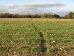
Pass through the farm and continue on for a short distance until the track ends at a road immediately to the north of Wade Bridge over the River Blackwater. Turn right to had north along this road, and after a few yards when the road turns to the left continue straight on along a footpath. This skirts some woodland on the left, before entering open fields. A little over two miles after the road, the footpath ends at the A3090 to the west of Romsey.
Turn right to head northeastwards, passing a roundabout until the river Test is reached. Just before the bridge turn left to follow a track northwards, with the river on the right. When Saddler's Mill is reached turn left and then right, to join a footpath that heads northwestwards along the floodplain of the river, heading to the east of the sewage works. A couple of small plank footbridge lead over a couple of streams, and three-quarters of a mile after the mill the path reaches Squabb Wood near Monk's Cottages.
Enter the woodland, and follow a footpath that leads northwestwards through the trees, heading to the west of Roke Manor. At SU333222 turn right down a path that heads northeastwards off the main path; this soon leaves the trees into a small clearing, before re-entering the trees for a short period. After it leaves the trees again it turns to the left, skirting the northern edge of the woods to the edge of a field, and then turning right to head northwestwards for a short distance to Old Salisbury Lane. Turn right to follow the lane eastwards for a mile until it ends at a T-junction with the B3084 near Lone Barn Farm.
Continue straight on eastwards along the B3084 for 0.4 miles until it ends at a T-junction with the A3057. Carefully cross the road near the pub, and continue on along a footpath that soon curves to the right to head south along the western bank of the River Test for a few hundred yards until it ends back at the A3057 by Great Bridge. Follow the A3057; soon a pavement starts, which can be followed southwards for two thirds of a mile as it approaches the northern outskirts of Romsey. It passes an industrial estate on the left, and then immediately heads under a rail bridge. At a roundabout on the other side turn left to parallel the railway line for a shirt distance, and then take the first road off to the left, still the A3057, which heads southeastwards. After a few hundred yards turn left to walk up the station approach to Romsey station, where this walk ends.
 |
 |
|
 |
 |
|
Distances
| From | To | Distance (m) | Ascent (ft) | Descent (ft) |
|---|---|---|---|---|
| Brockenhurst station | Langley Lodge | 7.0 | 305 | 233 |
| Langley Lodge | Eling Wharf | 3.0 | 39 | 164 |
| Eling Wharf | Roke Manor | 11.2 | 413 | 213 |
| Roke Manor | Romsey station | 2.8 | 16 | 174 |
This makes a total distance of 24.0 miles, with 773 feet of ascent and 784 feet of descent.
For more information on profiles, ascents and descents, see this page
Transport
There are regular train services running between Romsey and Brockenhurst, with a change required at Southampton Central station. See the National Rail Enquiries website for more details.
 |
 |
|
 |
 |
|
 |
 |
|
Disclaimer
Please note that I take no responsibility for anything that may happen when following these directions. If you intend to follow this route, then please use the relevant maps and check the route out before you go out. As always when walking, use common sense and you should be fine.
If you find any information on any of these routes that is inaccurate, or you wish to add anything, then please email me.
All images on this site are © of the author. Any reproduction, retransmissions, or republication of all or part of any document found on this site is expressly prohibited, unless the author has explicitly granted its prior written consent to so reproduce, retransmit, or republish the material. All other rights reserved.
Although this site includes links providing convenient direct access to other Internet sites, I do not endorse, approve, certify or make warranties or representations as to the accuracy of the information on these sites.
And finally, enjoy your walking!
Nearby walks
| # | Title | Walk length (miles) |
|---|---|---|
| 307 | Bursledon to Southampton | 9.2 |
| 308 | Southampton to Fawley | 16.4 |
| 309 | Fawley to Bucklers Hard | 15.4 |
|
|

|