Walk #867: A circular walk from West Bexington to Langton Herring
 |
 |
|
General Data
| Date Walked | 08/08/2010 |
| County | Dorset |
| Start Location | West Bexington |
| End Location | West Bexington |
| Start time | 10.01 |
| End time | 17.05 |
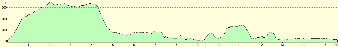
| Distance | 15.7 miles |
| Description | This was a very pleasant walk, following parts of the South Dorset Ridgeway and the South West Coast Path. |
| Pack | Today I carried my 30-litre Karrimor rucksack, filled with water, my waterproofs, a couple of books and other odds and ends. |
| Condition | I am slightly tired after this walk, but have suffered no problems. |
| Weather | The day started off with a curtain of thin cloud and a brisk, chilling breeze. The skies were hazy, spoiling thw views. As the day progressed the clouds lifted, leaving a sunny, warm day. |
| OS map | Landranger number 194 (Dorchester & Weymouth, Cerne Abbas & Bere Regis) |
 |
 |
|
Map of the walk
Maps courtesy of Google Maps. Route for indicative purposes only, and may have been plotted after the walk. Please let me have comments on what you think of this new format. For a detailed table of timings for this walk, please see the table file.
 |
 |
|
Notes
Sencan and I had last walked the proper' coast path (as opposed to the loop around the Isle of Portland) a couple of years ago, reaching the small Dorset village of Langton Herring. Today we decided to resume the walk. Unfortunately there was no public transport to and from the village, and I was forced to plan what looked like a pleasant circular walk, also taking in some of the Dorset Ridgeway.
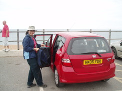
We arrived at the car park in West Bexington in time honoured-tradition: later than I had hoped. The ticket machine for the car park was taped up out of order, meaning that the handful of cars scattered about got a free day at the seaside. We pulled our gear together ready to go as a couple walked past carrying heavy rucksacks. It was surprisingly chilly despite the bright day, and so we both headed off with our coats on to protect us from the breeze.
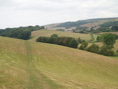
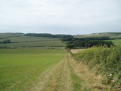
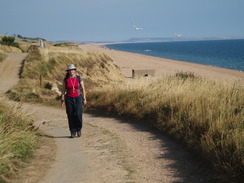
Initially we followed a road uphill through West Bexington, with good views back over the shingle beach and sea. The road soon ended and a steep path led up the hill towards the B3157 road. The views from the top were expansive and good; the breeze was stiffer, but the ascent had caused us to build up enough of a sweat and so we took our coats off. To the south were good views over the English Channel, whilst to the north were the rolling South Dorset hills. For this stretch of the walk we were following the South Dorset Ridgeway, an inland diversion of the South West Coast Path. This had been routed to avoid the main road, which was surprisingly busy on this Sunday morning.
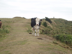
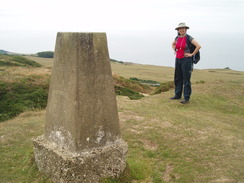
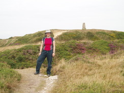
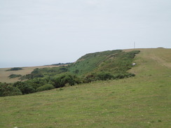
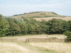
We passed some tumuli before the ramparts of Abbotsbury Castle - an Iron Age settlement - became visible ahead. We had to cross the main road before we climbed up to reach the ramparts. A cow was guarding the entrance to the fort, and this reluctantly moved away as we reached it. A trig pillar marks the summit of the fort, and we diverted a few yards from the fort to reach it. This allowed me to take some pictures containing both Sencan and a trig pillar, which I always find strangely pleasing. Jokes about concrete erections need not be made.
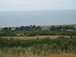
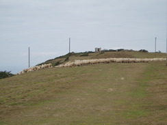
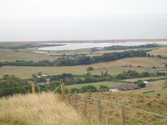
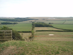
The path that led westwards proved to be an easy and relatively level walk. We heard distant whistles, and then saw a farmer on a quadbike herding sheep far below. Views of St Catherine's Chapel and Abbotsbury became visible below, with the curving sweep of Chesil Beach in the distance. We approached some tumuli as the sheep crested the hill behind us, swiftly followed by the sheepdogs and the farmer.
We could have taken a short cut down to Abbotsbury, but instead decided to continue along the trail at the top of the hill for another mile before cutting downhill. As we approached the point where we would leave the trail a man jogged past us, heading for a bike that lay against a hedge. We reached it at the same time he did, and he told us that he had just seen a slow worm on the trail. He lived locally, and it was the first time he had seen one whilst out running.
A steep descent took us down a sunken green track onto a road that led into Abbotsbury. On the way we met a man who was climbing uphill towards us. We stopped to say hello, and it turned out that he did Thai Chi, which Sencan has also taken up. They chatted for ten minutes about the activity and life in general as I stood to one side. Slowly I started to realise that this was going to be a very start-and-stop day. It was a pleasant chat, and eventually we left him to his walk and headed down into the village.
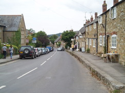
Abbotsbury is a very attractive little village, with stone houses on either side of the main road. We decided not to nip into the pub, and instead walked on. We soon reached another diversion; Sencan found a sign for Dorset Apple Cake, and we headed off to the house where it was sold. The owner sold us a large cake, which Sencan stuffed into her rucksack, leaving me to carry all of the stuff that had been in her sack. Thus encumbered, we strolled on along the winding road, not a pleasant experience due to the narrowness and heavy traffic.
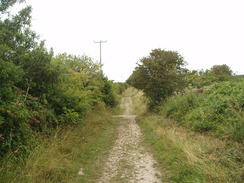
Fortunately we did not have to endure it for long, and we were soon heading along the track that led towards the hamlet of West Elworth. After a little navigational difficulty, we sat down on the hillside and munched the sandwiches we had made for lunch. It was a pleasant place to stop, although the South West Coast Path, which we would be walking later, was only a few hundred metres away on the other side of the hill. That was still many miles away, however.
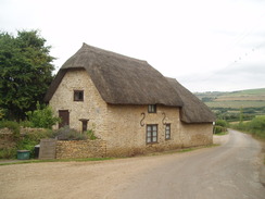
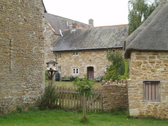
We set off once more, soon reaching the pretty hamlet of West Elworth, whose buildings were made from the same stone as Abbotsbury, but had the benefit of thatched roofs. A lane and path took us from this to the smaller East Elworth, where the path wound around the attractive farm buildings before climbing uphill once more. Another bridleway took us over the hill before dropping us down unceremoniously into the hamlet of Rodden.
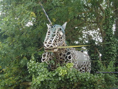
The mile-long road walk south to Langton Herring was enlivened by two things: a statue of a unicorn outside a farm, constructed from old horseshoes, and, further on, a sculpture of a man in a field, constructed from old car parts and gas cylinders. Sadly we could not get a very good frontal view of the latter sculpture, but it looked intriguing from the side. There was not much else to note until we reached Langton Herring, where we met the route we had walked on the previous walk. Indeed, all the walk we had done so far today was just to get us here.
I was quite tempted to divert off to the pub in the village, but Sencan wanted to walk on. We headed down the hill into the village, where we joined the South West Coast Path, which makes a sweeping diversion inland at this point. Initially the path followed the valley floor, which had been badly flooded on my previous walk along this stretch in January 2003. This time the ground underfoot was parched, and ahead lay the next climb of the day as the path skirted past Wyke Wood. Unfortunately this height was not kept for long, and the path was soon diving down to reach a road.
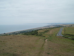
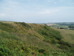
Another steep climb soon followed, and we were left puffing and panting for breath at the top of Merry Hill. I figured that this was the last steep ascent of the day, something I was slightly wrong about. A sign stated that the South West Coast Path was going to be diverted soon, but only by a few yards. The next stretch of walk was along the top of the escarpment, and there were some good views to be had over the Fleet despite slightly hazy skies. Unfortunately we had both run out of water by now, and we were desperately in need of some refreshment.
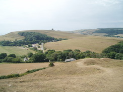
A large extended family were walking along the footpath at the top of the hill, and we slowly overhauled them before descending the steep slope down Linton Hill and to the road to the south of Abbotsbury. The large stone bulk of St Catherine's Chapel was easily visible on the hillside ahead of us, and the western tip of the Fleet off to our left. We reached the road and walked on towards the car park belonging to Abbotsbury Swannery. This had been closed on my last walk, but this time it was open. Thankfully, so was the cafe attached to the swannery. We went in and bought some water and cake to bide us over. It made for a very pleasant place to stop for a while.
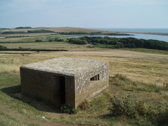
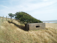
Eventually we set off once more, climbing the real last climb of the day onto the flank of Chapel Hill, with St Catherine's Chapel sitting proudly at the top. I had never been to the top, but we were both a little too tired to do so today. Instead we walked on, passing a couple of concrete pillboxes, one of which had been partly disguised by windswept bushes.
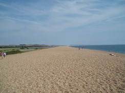
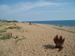
The path led us towards the shingle bank of Chesil Beach. From here navigation was simple; just follow the path and tracks that ran along the rear of the bank. Views of the sea were cut off by the massive bank, and so we climbed up to the top and then descended past lots of anglers, holidaymakers and sunbathers to dip our boots into the sea. Walking along the shingle proved to be as hard as ever, and we soon headed back to reach the path.
The going was much easier along the path, especially when it became a rough surfaced track. A couple of stone blocks engraved with an admiralty anchor were obvious signs of the work that had been done here over the Second World War, including testing of Barnes Wallis's Bouncing bomb in 1942.
As we passed the Old Coastguards Cottages - some of which are now holiday homes - Sencan realised that she had lost the cover to the battery compartment of her MP3 player. I waited as she strolled back a couple of hundred yards, but to no avail - there was little chance of finding it. Instead we headed on; the car park became visible long before we actually reached it, making the last half-mile or so quite hard going mentally.
It had been a good day's walk, but the views had been slightly spoiled by the hazy skies. There had also been a great distance walked only to complete a relatively short stretch of the South West Coast Path. The next section west towards Lyme Regis should be very different but also very strenuous, with Golden Cap and other hills to be climbed past West Bay. Hopefully we will not leave it two years before we walk it.
 |
 |
|
Directions
This walk starts off at the seafront car park in West Bexington. Leave the car park and start heading uphill northeastwards along Beach Road, following the South Dorset Ridgeway. When the road curves to the left, continue straight on uphill along a sunken lane. Near the top of the hill the track forks; take the right-hand fork and follow this as it continues eastwards for a short distance until it approaches the B3157 road.
Do not join the B3157 road, but follow a path that heads southeastwards in the field slightly below it. At the end of the first field, it continues with the hedge on the right. Eventually it leaves the hedge and slowly angles towards the road. At SY550866 carefully cross the road, and then continue on along the path as it angles towards the summit of Abbotsbury Castle. It heads immediately to the south of the trig pillar, and the going is slightly rough in the area surrounding the pillar.
It descends to cross a road, and then continues on along the ridge of Wears Hill. Do not leave the path at SY571862, but instead continue on along the bridleway that sticks to the top of the hill. After a while it leaves the edge of the hill and heads eastwards across White Hill, with a plantation immediately to the north.
The South Dorset Ridgeway is left behind in a corner of a field at SY587863. Turn sharp right to start heading downhill diagonally across a field, keeping a couple of dew ponds on the left. Cross a stile at the bottom edge of this field, and then continue on downhill to the southwest along a green lane. This eventually ends at a road. Turn right along this road, and follow it downhill as it enters the village of Abbotsbury.
When Rosemary Lane is reached on the left, turn left and follow this lane for a short distance until it ends at the B3157 road in the middle of the village, opposite the main car park. Turn left to head eastwards, passing a pub on the left. Pass a couple of scattered houses on the right; at SY583851 leave the road and turn right to join a bridleway. This initially falls downhill between hedges to cross a small stream. Continue on for a few yards into an open field, then turn left through a gate to enter another field. An indistinct bridleway heads uphill southeastwards, soon curving to head in a more easterly direction across the middle of the field.
A hedge is soon met on the left; continue eastwards across a series of fields until it approaches West Elworth Farm. Here the track curves sharply to the left to descend for a few yards to reach a country lane. Turn right and follow the road as it heads eastwards past the farm; almost immediately it turns to the right to continue heading uphill. After a few yards take a track that leads off to the left, heading eastwards towards East Elworth.
On the map the footpath heads immediately to the south of the farm at East Elworth, past a little cottage. On the ground the footpath followed the track as it curves to the left to head downhill towards the farm. Follow the track past the farm buildings, before the footpath heads off to the right, becoming overgrown as it headed steeply uphill. At the top of the hill it joins a bridleway; turn left and start following this as it heads eastwards along the crest of the hill. Continue on for half a mile until it starts to descend down to end at a road in Rodden.
Turn left along this road, and follow it as it curves to the right to and at a junction with another road. Turn right along this road and follow it as it heads southwards for a mile. It climbs up a hill to enter Langton Herring; take the first road off to the right (just uphill from a left-hand bend). This road initially heads south, before curving to the right to take a more westerly course. When the road ends join a footpath that continues on westwards across fields. This slowly curves to the left as it descends, meeting the South West Coast Path in the valley at the bottom.
The South West Coast Path is followed to the end of this walk. Turn right and start following the path northwards along the valley. When a small stream is reached turn left to follow it northwestwards until the eastern edge of Wyke Wood is reached. Here turn right and follow the edge of the trees uphill to the north. At the top of the hill turn left with the trees on the left for a short distance; cross a stile into a new field and then turn right, with a hedge on the right. When another hedge is reached turn left to head westwards as the path descends downhill to reach a road.
Cross this road and follow a footpath westwards on the other side. After a couple of hundred yards turn right, crossing a stile and then following a hedge steeply uphill to the north. At the top of Merry Hill turn left and follow an obvious path that hedges along the top of the escarpment, with occasional good views over the Fleet and Chesil Beach to the south. The path slowly descends as it heads westwards, curving to the right slightly. At the end of the escarpment the path descends steeply downhill to meet a road to the south of Abbotsbury.
Turn right and follow this road westwards until the car park of Abbotsbury Swannery is reached on the left. The path follows the main driveway past the car park to the entrance of the swannery, before curving to the right and joining a track that heads in a more northerly direction. Leave this track at roughly SY575848 by turning to the left to join another footpath. This crosses a stream; immediately after this turn to the left and start following a path southwards along the eastern side of Chapel Hill.
The path skirts the side of the hill, slowly curving to the right to pass its southern side. A small track is eventually joined as the path heads slowly downhill to the west with a hedge on the left. This eventually ends at a T-junction with a track at SY567846. Here turn left, to follow the track southwestwards for a few hundred yards before curving to the right to take a more westerly course.
This track soon reaches the rear of Chesil Beach. Here you have a choice; you can walk along the top of the ridge or at the surfline; however, this is hard going over the shingle. An easier route is to follow the path that runs on the inland side of the shingle bank. This soon meets a road by a car park. Follow this road for a couple of miles northwestwards from the car park; the road changes to be a private track, becoming rougher all the way to The Old Coastguards cottages. The track ends here, and a footpath continues on back to the car park in West Bexington, where this walk ends.
Distances
| From | To | Distance (m) | Ascent (ft) | Descent (ft) |
|---|---|---|---|---|
| West Bexington | Abbotsbury | 5.0 | 860 | 719 |
| Abbotsbury | Langton Herring | 3.6 | 328 | 423 |
| Langton Herring | West Bexington | 7.1 | 768 | 814 |
This makes a total distance of 15.7 miles, with 1956 feet of ascent and 1956 feet of descent.
For more information on profiles, ascents and descents, see this page
 |
 |
|
 |
 |
|
 |
 |
|
 |
 |
|
 |
 |
|
 |
 |
|
 |
 |
|
 |
 |
|
 |
 |
|
 |
 |
|
Disclaimer
Please note that I take no responsibility for anything that may happen when following these directions. If you intend to follow this route, then please use the relevant maps and check the route out before you go out. As always when walking, use common sense and you should be fine.
If you find any information on any of these routes that is inaccurate, or you wish to add anything, then please email me.
All images on this site are © of the author. Any reproduction, retransmissions, or republication of all or part of any document found on this site is expressly prohibited, unless the author has explicitly granted its prior written consent to so reproduce, retransmit, or republish the material. All other rights reserved.
Although this site includes links providing convenient direct access to other Internet sites, I do not endorse, approve, certify or make warranties or representations as to the accuracy of the information on these sites.
And finally, enjoy your walking!
Nearby walks
| # | Title | Walk length (miles) |
|---|---|---|
| 316 | Lulworth Cove to Wyke Regis | 13.7 |
| 317 | A circular walk around the Isle of Portland | 13.3 |
| 318 | Wyke Regis to West Bexington | 14.3 |
|
|

|