Walk #7: Waterbeach - Burwell - Swaffham - Waterbeach
General Data
| Date Walked | 24/01/1999 |
| County | Cambridgeshire |
| Start Location | Waterbeach |
| End Location | Waterbeach |
| Start time | 08.05 |
| End time | 13.45 |
| Distance | 17.1 miles |
| Description | This walk followed the Cam and various lodes around a beautiful area of Fenland. |
| Pack | My pack was of medium weight. I carried a sleeping bag, cooker, maps and spare clothes, but no food or excess weight. |
| Condition | The underside of my left knee is still giving slight problems, although it wasn't as bad as on the Downham Market walk. I tries wearing the pair of '1000 mile' socks that I bought the previous day, and whilst they are very comfortable I did get blisters. When I stopped for lunch in Swaffham Bulbeck I put one of my normal socks over the top of the new one on my right foot, and this improved that foot's condition manyfold. I assume that my blisters would not have been as bad if I had had two layers on when I set off. |
| Weather | Today was sunny at the start, although it slowly started clouding over. There was a slight breeze with no rain, making it a good day for walking. |
| OS map | Landranger number 154 (Cambridge & Newmarket, Saffron Walden) |
Map of the walk
Maps courtesy of Google Maps. Route for indicative purposes only, and may have been plotted after the walk. Please let me have comments on what you think of this new format. For a detailed table of timings for this walk, please see the table file.
Notes
This was a pleasant day's walk following various waterways through the Cambridgeshire Fens. I had not explored many of these before, so it was surprising to find that it was enjoyable despite the flat terrain. I started off at my flat in Waterbeach; to walk from Waterbeach station you will need to add 2,5 miles onto the day's total.
Burwell Lode was fascinating - what looks as though it may be a simple drainage channel might have a much more ancient history. Although weed-choked at the moment, it is hardly surprising that at one time it was a busy waterway, for there were few other routes to connect the little island villages that dominated the Fens before they were drained.
The long road walk along the B1102 should have been boring, but I quite enjoyed it, especially when passing the intriguing bank and ditch of Devil's Dyke. I stopped for a while at Swaffham Bulbeck, nipped into a shop to buy some chocolate and then sat down on a bench by the village green. It was a pleasant place to stop despite it being midwinter. After this a further stroll along the B1102 led me to Lode, where a long road walk took me back along Bottisham Lode back to the River Cam at Bottisham Lock.
Directions
Walk eastwards from Waterbeach to the river at Bottisham lock. Cross over to the eastern bank of the river via the bridge and walk northwards for 3.5 miles to Upware and the entrance to Burwell Lode. Cross the bridge over the lode, and then turn right to start following the northern bank eastward for 3.3 miles.
Follow Bottisham Lode to Burwell village. It turns sharply to the left for a fifth of a mile before meeting a road; turn right down the road and follow itsoutheastwards into Swaffham Bulbeck. When it ends turn right to follow a road south for nearly a mile until it meets the B1102. Continue straight on and head south, passing the church on the right.
At a major road junction turn right to head southwestwards down the B1102 for four and a half miles, passing through the villages of Swaffham Prior and Swaffham Bulbeck, where the road goes around a couple of sharp bends. Continue on the B1102 towards the picturesque village of Lode.
From the B1102 turn right into Lode village and follow the main street through the village to Bottisham Lode. After a couple of miles the road curves sharply to the right; here join the banks of the lode and follow it northwestwards for a little over half a mile until the River Cam is reached just to the north of Bottisham Lock. From here, retrace your steps to your starting point.
Distances
| From | To | Distance (m) | Ascent (ft) | Descent (ft) |
|---|---|---|---|---|
| Waterbeach | Burwell | 8.6 | 59 | 23 |
| Burwell | Lode | 5.0 | 69 | 92 |
| Lode | Waterbeach | 3.5 | 7 | 20 |
This makes a total distance of 17.1 miles, with 135 feet of ascent and 135 feet of descent.
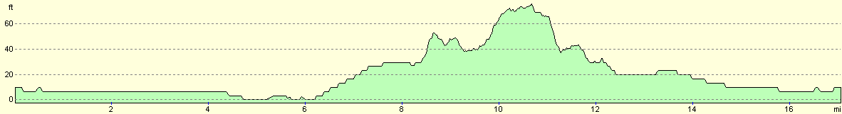
For more information on profiles, ascents and descents, see this page
Disclaimer
Please note that I take no responsibility for anything that may happen when following these directions. If you intend to follow this route, then please use the relevant maps and check the route out before you go out. As always when walking, use common sense and you should be fine.
If you find any information on any of these routes that is inaccurate, or you wish to add anything, then please email me.
All images on this site are © of the author. Any reproduction, retransmissions, or republication of all or part of any document found on this site is expressly prohibited, unless the author has explicitly granted its prior written consent to so reproduce, retransmit, or republish the material. All other rights reserved.
Although this site includes links providing convenient direct access to other Internet sites, I do not endorse, approve, certify or make warranties or representations as to the accuracy of the information on these sites.
And finally, enjoy your walking!
Nearby walks
| # | Title | Walk length (miles) |
|---|---|---|
| 2 | Waterbeach to Newmarket Road, Cambridge | 5.4 |
| 5 | A short walk around Waterbeach to Car Dyke | 3.0 |
| 6 | Waterbeach to Newmarket Road, Cambridge | 5.4 |
|
|

|