Walk #13: Edale and Kinder Scout
General Data
| Date Walked | 13/03/1999 |
| County | Derbyshire |
| Start Location | Edale Car Park |
| End Location | Edale Car Park |
| Start time | 09.50 |
| End time | 16.20 |
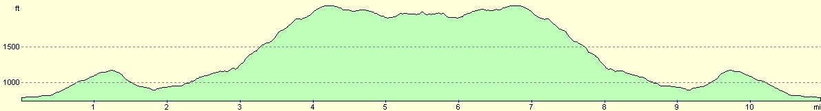
| Distance | 11.0 miles |
| Description | This was a route from Edale following the Pennine Way up Jacobs Ladder to Edale Cross and then to Kinder Downfall. |
| Pack | I carried full pack today, a weight of 31 pounds. |
| Condition | Reasonable. Legs very tired. Slightly pulled the right calf muscle extracting myself from a snowdrift. |
| Weather | Today's weather was beautiful. Sunny, with a slight wind on the top of Kinder Scout. There was snow from about half way up Jacobs ladder which made the going slow. I ended up with boots full of water from going into the snow one too many times. |
| OS map | Outdoor Leisure number 1 (The Peak District - Dark Peak Area) |
Map of the walk
Maps courtesy of Google Maps. Route for indicative purposes only, and may have been plotted after the walk. Please let me have comments on what you think of this new format. For a detailed table of timings for this walk, please see the table file.
Notes
This was a pleasant walk following the first few miles of the Pennine Way onto Kinder Scout. The weather was beautifully sunny, and a glider flew overhead as I approached Kinder Downfall. There was some thick snow on the top, hiding the worst of the groughs. All in all it was a superb day for a great walk over Kinder. At one point I slipped into one of these, and when I clambered out my gaiters were filled with wet slush and snow. Even this mild problem could not put a dampener on a wonderful day's walk.
Directions
Simply follow the Pennine Way from Edale to Kinder Downfall via Jacobs Ladder and back. If the weather is good you may want to return from Kinder Downfall via Grindsbrook Clough and the centre of Kinder, but on the day in question the weather was not good enough - the snow was too deep!
This walk is a nice strenuous hike with a fairly steep climb from Jacobs Ladder up to the Kinder Low Trig Point. Routefinding is very easy as this route follows the first 5-6 miles of the Pennine Way.
Distances
| From | To | Distance (m) | Ascent (ft) | Descent (ft) |
|---|---|---|---|---|
| Edale car park | Kinder downfall | 5.5 | 1755 | 597 |
| Kinder downfall | Edale car park | 5.5 | 597 | 1755 |
This makes a total distance of 11.0 miles, with 2352 feet of ascent and 2352 feet of descent.
For more information on profiles, ascents and descents, see this page
Disclaimer
Please note that I take no responsibility for anything that may happen when following these directions. If you intend to follow this route, then please use the relevant maps and check the route out before you go out. As always when walking, use common sense and you should be fine.
If you find any information on any of these routes that is inaccurate, or you wish to add anything, then please email me.
All images on this site are © of the author. Any reproduction, retransmissions, or republication of all or part of any document found on this site is expressly prohibited, unless the author has explicitly granted its prior written consent to so reproduce, retransmit, or republish the material. All other rights reserved.
Although this site includes links providing convenient direct access to other Internet sites, I do not endorse, approve, certify or make warranties or representations as to the accuracy of the information on these sites.
And finally, enjoy your walking!
Nearby walks
| # | Title | Walk length (miles) |
|---|---|---|
| 12 | Darley Dale, Stanton Moor and Rowsley | 8.7 |
| 14 | Friden, Long Dale and Gratton Dale | 7.8 |
| 16 | Darley Dale - Winster - Matlock | 7.0 |
|
|

|