Walk #16: Darley Dale - Winster - Matlock
General Data
| Date Walked | 03/04/1999 |
| County | Derbyshire |
| Start Location | Darley Dale |
| End Location | Matlock Station |
| Start time | 13.15 |
| End time | 16.15 |
| Distance | 7.0 miles |
| Description | This walk was from Darley Dale to Winster avoiding the majority of the road, and then following the Limestone Way before dropping down to Matlock via the Bonsall to Matlock road. |
| Pack | Today I carried full backpacking kit. |
| Condition | I feel fine after this walk. My legs got tired towards the end, but the initial climbs were all okay. Had trouble with my left foot because one toenail was slightly too long - got sore because it was being pressed inwards. |
| OS map | Outdoor Leisure number 24 (The Peak District - White Peak Area) |
Map of the walk
Maps courtesy of Google Maps. Route for indicative purposes only, and may have been plotted after the walk. Please let me have comments on what you think of this new format. For a detailed table of timings for this walk, please see the table file.
Notes
This was a pleasant walk through an area that I know well - it had more than a few ascents and descents, which was one of my reasons for choosing it as a training walk. A few miles were spent on the Limestone Way, which I shall be doing in the next couple of months. It is wonderful scenery, and although this area of the Peak District is less visited than some of the more famous dales, it is fantastic. The remains of old mines (mainly lead) dominate the surroundings, the piles having slowly returned to nature. To make matters better, at the end of the walk I caught a steam train back to my car. What could be better than a good walk and a ride on a train?
Directions
Start off in Darley Dale Station car park. There is ample parking in the surrounding area.
Walk down the B5075 towards Darley Bridge and Winster. There is a pavement on the right-hand side of the road. Cross the River Derwent at Darley bridge. Take the first road to the right and follow it uphill. Just before you reach the Einhoven works turn left along Oldfield Lane. Follow this road until a series of paths enter out from the left. Take the first path on the left, which heads downhill to the southwest. Do not branch off to cross the stream, but instead continue straight on through the trees.
The path eventually crosses the little stream and continues southwestwards up the hill. It eventually reaches the B5075 road at SK247606. Turn right and follow the road west into the village of Winster. When you get to the marketplace, turn left for a short way uphill until just after a pub and take the footpath that leads uphill to the southeast.
Eventually you reach the Limestone Way near Luntor Rocks. Follow this trail as it heads southeastwards until just before Bonsall Village is reached. If you want to extend the walk you can continue along the Limestone Way into the village, but at Moorlands Lane (SK268590) I continued along the lane until it met a road. Turn right along another road, and then almost immediately left to start heading eastwards.
Follow this road downhill past the quarry and into Matlock. From here, go to the railway station and follow a path through the car park to Matlock Riverside Station. If you have timed things correctly, then you can catch a steam train back to Darley Dale.
Alternatively, if you want to extend the walk then you can follow a path alongside the railway line. To get to the path, walk from Matlock (BR) station across the car park and join a path alongside the river. Follow this path beside the large stone retaining wall until you have just passed a large steel railway viaduct over the river. Just past this viaduct there is a path that goes steeply up to the left. Follow this and cross the viaduct (note 2010: these directions may have changed slightly since the construction of a new supermarket in Matlock). The path then takes you for nearly two miles north alongside the railway line. Eventually you reach a cutting near Darley Dale where you cross the tracks and go up a slope. This path leads you to a road. Turn left along the road until near a stone bridge, and go down some steps. These steps lead to a path which takes you back to the station where you started.
Distances
| From | To | Distance (m) | Ascent (ft) | Descent (ft) |
|---|---|---|---|---|
| Darley Dale | Winster | 2.7 | 571 | 118 |
| Winster | Matlock | 4.3 | 446 | 902 |
This makes a total distance of 7.0 miles, with 1017 feet of ascent and 1020 feet of descent.
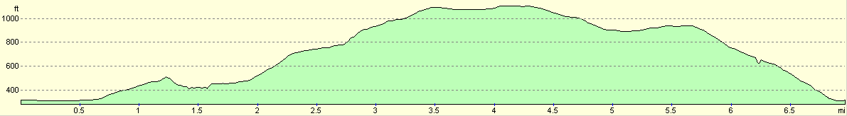
For more information on profiles, ascents and descents, see this page
Disclaimer
Please note that I take no responsibility for anything that may happen when following these directions. If you intend to follow this route, then please use the relevant maps and check the route out before you go out. As always when walking, use common sense and you should be fine.
If you find any information on any of these routes that is inaccurate, or you wish to add anything, then please email me.
All images on this site are © of the author. Any reproduction, retransmissions, or republication of all or part of any document found on this site is expressly prohibited, unless the author has explicitly granted its prior written consent to so reproduce, retransmit, or republish the material. All other rights reserved.
Although this site includes links providing convenient direct access to other Internet sites, I do not endorse, approve, certify or make warranties or representations as to the accuracy of the information on these sites.
And finally, enjoy your walking!
Nearby walks
| # | Title | Walk length (miles) |
|---|---|---|
| 11 | Stanton Moor | 2.9 |
| 12 | Darley Dale, Stanton Moor and Rowsley | 8.7 |
| 16 | Darley Dale - Winster - Matlock | 7.0 |
|
|

|