Walk #11: Stanton Moor
General Data
| Date Walked | 14/02/1999 |
| County | Derbyshire |
| Start Location | Stanton Moor car park |
| End Location | Stanton Moor car park |
| Start time | 15.00 |
| End time | 16.00 |
| Distance | 2.9 miles |
| Description | This was a short circular walk around Stanton Moor. I Walked from my usual car parking spot up onto Stanton Moor, up to and past the Nine Ladies Stone Circle, across the Moor and eventually back to my car. Used the walking poles a fair bit for practice . |
| Pack | I carried no pack today. |
| Condition | I feel fine after this walk. |
| Weather | Okay to begin with, became misty and drizzly later. |
| OS map | Outdoor Leisure number 24 (The Peak District - White Peak Area) |
Map of the walk
Maps courtesy of Google Maps. Route for indicative purposes only, and may have been plotted after the walk. Please let me have comments on what you think of this new format. For a detailed table of timings for this walk, please see the table file.
Notes
This was a simple stroll around Stanton Moor, one of my favourite places in the Peak District, and one that I do not get to visit often enough. There are many items of interest on the moor including four Bronze Age stone circles, the most famous of which is the Nine Ladies Stone Circle. This circle of small stones is hardly visible until you are on top of them, but what they lack in size they gain in ambiance - the surroundings are spectacular, with the low, scrubby trees that surround it giving it a sylvan feel. Nearby is the Earl Grey Tower, which was built to commemorate the 1832 reform act, and the Cork Stone, which has handholds that allow you to climb up to the top.
For once I have not given precise directions as it is worth exploring the moor for yourself.
Directions
The directions for this walk are quite simple. Just basically walk around Stanton Moor following the relevant OS map, and ensure that you take in the following landmarks:
- The Cork Stone
- Nine Ladies Stone Circle
- The King Stone
The route I took headed north up the eastern side of the moor, passing the Earl Grey Tower and the Nine Ladies stone circle to a road, then returning along the western side of the moor above the old quarries to the Cork Stone.
Distances
| From | To | Distance (m) | Ascent (ft) | Descent (ft) |
|---|---|---|---|---|
| Stanton Moor car park | Stanton Moor car park | 2.9 | 377 | 377 |
This makes a total distance of 2.9 miles, with 377 feet of ascent and 377 feet of descent.
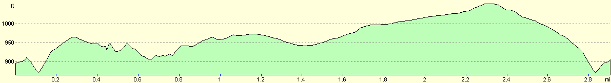
For more information on profiles, ascents and descents, see this page
Disclaimer
Please note that I take no responsibility for anything that may happen when following these directions. If you intend to follow this route, then please use the relevant maps and check the route out before you go out. As always when walking, use common sense and you should be fine.
If you find any information on any of these routes that is inaccurate, or you wish to add anything, then please email me.
All images on this site are © of the author. Any reproduction, retransmissions, or republication of all or part of any document found on this site is expressly prohibited, unless the author has explicitly granted its prior written consent to so reproduce, retransmit, or republish the material. All other rights reserved.
Although this site includes links providing convenient direct access to other Internet sites, I do not endorse, approve, certify or make warranties or representations as to the accuracy of the information on these sites.
And finally, enjoy your walking!
Nearby walks
| # | Title | Walk length (miles) |
|---|---|---|
| 133 | Hunstanton to Burnham Deepdale | 10.3 |
| 156 | Kings Lynn to Snettisham | 14.6 |
| 159 | Snettisham to Hunstanton | 10.3 |
|
|

|