Walk #118: Auchterarder to Crieff
 |
 |
|
General Data
| Date Walked | 23/09/2000 |
| County | Tayside |
| Start Location | Auchterarder |
| End Location | Crieff |
| Start time | 09.15 |
| End time | 13.00 |
| Distance | 9.7 miles |
| Description | A mixture of road and path walking greeted me today. There was nothing too stimulating on this walk (as it was mainly a positional walk to get me ready for the walk west from Crieff towards the west coast of Scotland), although the sections alongside the river were very nice, although muddy and infested slightly by insects. |
| Pack | Today I carried full Pennine Way kit. |
| Condition | I feel okay after this walk; I was a bit tired after this short walk, but as usual when I had finished I recovered very quickly. The going along the river sections were quite muddy in places, and this put some extra stress on my left (bad) ankle to the extent that it started to ache slightly, but again nothing serious and nothing that I got concerned about. |
| Weather | Today was a wet day. There was a constant drizzle for most of the time that I was walking, and this was coupled early on with a slight mist which meant that views of the hills were not available. After I had finished walking it started to clear up, and the sun even came out when I was waiting in Crieff for my bus to Perth. There were brief glimpses of sun on the approach to Crieff, but this was also followed by a period of drizzle. All in all it was the right sort of day on which to finish a trip. |
| OS map | Landranger number 58 (Perth to Alloa, Auchterarder) |
Map of the walk
Maps courtesy of Google Maps. Route for indicative purposes only, and may have been plotted after the walk. Please let me have comments on what you think of this new format. For a detailed table of timings for this walk, please see the table file.
Notes
Today was quite a boring walk northwest from Auchterarder to Crieff, the main purpose of which was to act as a positioning walk for the trip west to Spean Bridge. It involved mostly road walking, but a lucky discovery en route allowed a fair amount of road walking to be cut and replaced with paths. I generally do not mind road walking that much (as witnessed by the journey from Edinburgh out towards Dollar) but it was a shame after such a spectacular day yesterday to have no more hills to climb. Having said that, at various times today when the drizzle had temporarily lifted there were some lovely views of the hills to the north and northwest through which I will be walking on my next trip.
During the planning of the walk I had been intending to follow a road that is shown crossing the River Earn at NN 888185, just south of the hamlet of Dalpatrick. Unfortunately I had not noticed that the crossing was a ford, and with the rain that we had had over the last few days I decided to alter the route to a longer one that followed roads to the south of the river.
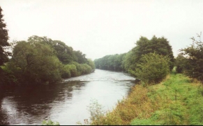
When I reached Strageath Hill on this diversion I discovered a sign declaring a public footpath to Crieff. I had a luck on my map, and there was no sign of any footpath. I decided to take a look, and the footpath soon ended at the old Auchterarder to Crieff railway line. A sign here showed footpaths leading south to Muthill and north to Crieff. All the stiles and signs looked brand new, so it was no surprise when I shortly came across two men sheltering under a bridge from the drizzle and they told me that the footpath had only been open a few weeks, so I had been lucky indeed to find it open. Apparently it links Crieff with the village of Muthill to the south. Heading northwards along the path I soon reached the River Earn, where the old pillars of the railway bridge were clearly visible. The path then followed the river all the way into the southern outskirts of Crieff.
When I set off this morning I was feeling relatively fit, and as I had two free days on my schedule I was considering walking on for another couple of days from Crieff towards Killin along the Famous Highland Drove route. There were three reasons not to do this; firstly I had not been expecting to get that far on this trip and had not brought along the relevant maps for the area west of Crieff or the guidebook. I could have bought the relevant map again, but I really did not want to. Secondly the weather today was non-optimal, and I did not really want to have to walk any further as I was slightly wet. Thirdly I felt like I wanted to have another few days in Edinburgh and a rest, and if I had continued walking I would be going straight back to work after the trip, which may not have done my sanity much good! So with a heavy heart I decided to stop the trip at Crieff, which was a day beyond where I had been intending to finish anyway.
Looking back on that decision I have reasons to be extremely glad that I went back to Edinburgh, as the evening after I got back I met a girl who soon after moved down to Cambridge and has become my girlfriend. I find it amazing that sometimes the smallest decision can lead to such a major change in your life. If I had continued on to Killin would I ever have met Sam, and if we had met would we have ended up partners?
Crieff is a very nice little town, even on a dark and damp day. Every building seems to have some history, and the people were all very welcoming, even to a bearded hiker such as myself. Below the Tourist Information office is a tiny museum which houses two weathered old crosses that used to stand in the town. I spent a few pleasurable minutes reading about the way that Crieff has played an important and historic role in the history of the highlands and Scotland as it was the main market for the cattle brought over the mountain passes by the drovers.
So as another trip ends, I look back at a highly enjoyable ten days in Scotland - I can only hope that the other walks that I have to complete in the country can go as well as the ones on this trip have. The route now starts to get much more mountainous, and I will soon start to be in the territory of the Munros. This will be a challenge, but is one that I am very much looking forward to undertaking. I can hardly wait for next year to come so I can start these walks.
Directions
Head west along the A824 through Aucterarder and take road that leads off to the right past a garage and through Castleton. The road bends south-northwesterly at Backburn through some woodland (which had a wonderful smell of pine in the air thanks to the drizzle) and into Tullibardine.
At the junction at the end of the road turn left and then almost immediately turn right to head northwestwards towards Drumness. Continue along the road past Drumness and then cross the bridge over Machany Water.
Continue northwards along this road for abut two kilometres from the bridge. After passing to the left of Parkhead you soon reach a sharp left-hand bend in the road. A track continues straight on here northwards, crossing the River Earn by a ford, but the river was high when I visited so I followed the road to the left and did not even bother to visit the ford.
The road turns to head just south of westwards. Soon you reach a road which leads off to the right. Follow this road as it heads north and then bends to the west around Strageath Hill.
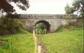
Just after a farm on the right a path leads off to the left over a stile. This path cuts across a field and joins the old Auchterarder to Crieff railway line in a slight cutting. Turn right down the old railway trackbed and pass under a nice stone bridge that carries the road you have just left over line. Continue on along the trackbed until you meet the River Earn.
Turn left and follow the south bank of the River Earn as it winds it's way northwestwards. After just over two miles the riverside paths divert past a trading estate and meets the A822 road. Turn right down this road and follow it to a bridge over the River. Continue over the bridge and follow the road uphill and into Crieff. The town centre is a short walk off to the right near the top of the hill.
Distances
| From | To | Distance (m) | Ascent (ft) | Descent (ft) |
|---|---|---|---|---|
| Auchterarder | Crieff | 9.7 | 571 | 689 |
This makes a total distance of 8.9 miles, with 571 feet of ascent and 689 feet of descent.
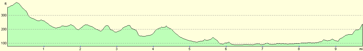
For more information on profiles, ascents and descents, see this page
Transport
There are regular bus services from Crieff to Killin, Perth and Auchterarder. Since I had decided to go back to Edinburgh, I caught one of the hourly busses to Perth, where I caught another bus south to the capital. There are also railway services between Edinburgh and Perth.
Disclaimer
Please note that I take no responsibility for anything that may happen when following these directions. If you intend to follow this route, then please use the relevant maps and check the route out before you go out. As always when walking, use common sense and you should be fine.
If you find any information on any of these routes that is inaccurate, or you wish to add anything, then please email me.
All images on this site are © of the author. Any reproduction, retransmissions, or republication of all or part of any document found on this site is expressly prohibited, unless the author has explicitly granted its prior written consent to so reproduce, retransmit, or republish the material. All other rights reserved.
Although this site includes links providing convenient direct access to other Internet sites, I do not endorse, approve, certify or make warranties or representations as to the accuracy of the information on these sites.
And finally, enjoy your walking!
This walk was mentioned in the following routes:
| My sectional Land's End to John O'Groats walk |
Nearby walks
| # | Title | Walk length (miles) |
|---|---|---|
| 117 | Dollar to Auchterarder | 12.0 |
|
|

|