Walk #199: Kylesku to Scourie
 |
 |
|
General Data
| Date Walked | 04/05/2002 |
| County | Highlands |
| Start Location | Unapool |
| End Location | Scourie Hotel |
| Start time | 10.08 |
| End time | 14.32 |
| Distance | 11.3 miles |
| Description | This was a long road walk through some dramatic and beautiful scenery. The mountains and the sea looked stunning in the late spring sunshine. |
| Pack | Full pack with five days food. |
| Condition | I am okay after this walk - my right knee ached at times and both my feet were slightly sore, but nothing to overly concern me. |
| Weather | The weather today was beautiful, with bright sunshine and only occasional periods of cloud. It was warmer than yesterday, but I was kept cool by a nice breeze that occasionally blew. |
| OS map | Landranger number 15 (Loch Assynt, Lochinver & Kylesku) and Landranger number 9 (Cape Wrath, Durness & Scourie) |
 |
 |
|
Map of the walk
Maps courtesy of Google Maps. Route for indicative purposes only, and may have been plotted after the walk. Please let me have comments on what you think of this new format. For a detailed table of timings for this walk, please see the table file.
 |
 |
|
Notes
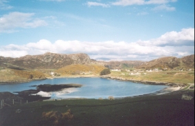
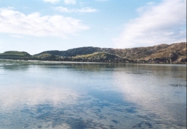
This was a relatively short walk along public roads, but one which I enjoyed nonetheless. The weather today was the best of the trip so far, and this in itself put me in a good mood. Because of the nice weather I also dawdled and took my time; I could see little point in rushing in such weather, especially as the distance to be walked was so short. For the first time on this trip I had a close association with the sea, I had seen it yesterday but today the route actually followed close to the coast for periods. This is the first time that I have been able to wet my boots in the sea (as opposed to estuaries or firths) on my Land's End to John O'Groats walk since Minehead, which seems a very long time ago. It also feels good, as being near the sea when the sun is shining is an uplifting experience for my soul, and as I wet my boots this evening in the sea a Scourie Bay I felt more refreshed and relaxed than I have during the entire trip so far.
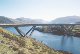
I spent a little time around Kylesku Bridge, taking some photographs of it against the dramatic mountain backdrop and studying it's design. In the car park on the northern side I looked at the memorial to the submariners who trained at Kylesku during the second world war - it was a training base for two and four man midget submarines. I can imagine that it must have been a very cold and exposed posting in winter.
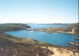
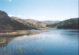
Because I was feeling fit I decided to take a diversion down the old road towards Duartbeg. This started off as a good single-track road as far as a little slipway beside a beautiful creek which led to the sea. This was a beautiful spot but it was spoilt slightly by a large collection of tyres which had been dumped there. A very narrow clapper gate had to be negotiated (I could not get through it so I had to open the very rickety gate beside it to get through). There then followed a superb section of path, which followed the old tarmac road which was now mostly covered by plants. This made me think how quickly the works of man would be covered if nature were allowed to run it's course with no intervention. This section had some great views out to sea over Loch Duartbeg, with the islands out to sea to the west highly visible in the glistening sea. The path ends at a minor road by Duartbeg Lodge, and the next stretch of road also had some great views out to sea. Although this diversion was longer than the route following the A894, it was well worth the extra distance and was a wonderful little walk. If it had been raining my opinion may have been different, however.
Since I am getting towards the end of the walk I decided to phone up and see if the Cape Wrath minibus is running on Wednesday when I should get there. Fortunately it is, and the Royal Navy will not be bombing on the range until the 20th of May. I was told that there is a bothy at Kervaig, which is something I have heard a rumour of before. I will probably therefore make that my target for Tuesday night as it is only three or four miles to the east of the Cape Wrath lighthouse. I have also booked myself into the hotel at Rhiconich for tomorrow night which means that I can split the remaining walk into equal stages and be able to have a night of luxury before two nights camping or in bothies.
I now only have three days walking left to get to Cape Wrath, and four days to Durness; this will probably be split into legs to Rhiconich, Blairmore (or Sandwood Bay), Cape Wrath (or Kervaig) and finally Durness. For the last few days I have had the impression that I should be able to do it; being three days ahead of schedule will help as I can afford to take a rest day if necessary.
This B&B is a bit far out of the village for my liking; it is at the top of a hill to the west of the village overlooking Scourie Bay. On the other hand the weather is fine and it will be a nice evening for a walk to the hotel for a meal. When I got to Scourie I descended down the hill to the hotel and then started looking for a B&B. There was an obvious sign for one in the village centre so I walked up to it but no-one was in. I decided to go to the hotel and have a drink, but they were unfortunately just closing up. I asked some of the locals about B&B's, and a young man went to the shop and phoned a few up for me. The lady in the B&B that I am staying in was in, so the gent very kindly gave me a lift up here, which saved me lugging my pack all the way up the hill. Just as we set off however, he saw the car of the lady who owns the one in the centre, but of course I had already booked into this one. The view from my room over Scourie Bay is superb, and the landlady is giving me the room for four pounds less than the usual price of nineteen pounds. This was exceedingly kind of her, and I shall give the money to the charity.
In the evening I went for a meal to the Scourie hotel. It had been both the English and Scottish cup finals, and Rangers and Arsenal had won (which pleased me as they were the ones that I wanted to win, not that I cared much). Half the people in the village seemed to want Rangers to win and the other half Celtic; I decided that it might be better to keep my preferences quiet!
Directions
This walk starts off at 'The Ridge' B&B, which is situate off the A894 road in Unapool, about a mile to the Southeast of Kylesku.
Turn right out of the B&B and walk along the minor access road until you meet the A894. Turn right onto the A894 and follow it for a short distance north-westwards to the top of the hill. After the summit is crested it starts to plunge downhill northwards until at the bottom it meets the access road at Kylesku coming in from the right.
Continue on along the A894 as it starts to climb again up to the Kylesku Bridge. On the other side it crosses the island of Garbh Eilean before descending to a causeway which is near sea level. Once the causeway has been crossed it starts to rise steeply past the access road to Kylestrome until a summit is reached at a car park and viewpoint near Loch Dubh a' Chnoic Ghairbh.
The road then settles into a north- northwesterly heading as it enters a wooded area. It passes the entrance road to Duartmore Bridge on the right before descending to a causeway that crosses the middle of Loch Duartmore. The road then starts to climb through a cutting, passing another access track to Duartmore Bridge, and then heads north-westwards immediately to the east of the 176-metre summit of Cnoc Chalbha.
Shortly after the road swings around to a westerly heading a track leads off to the left. This is guarded by a gate that proclaims that no unauthorised vehicles are allowed, but walkers are fine. Go down this track which is surfaced as it crosses over the Allt an t-Srathain and then follows the beck down to a lovely narrow-sided bay in the sea.
At the bay a path leads up the old road to the right,through a gate with a very narrow clapper gate beside it. Follow this very overgrown road as it heads north-westwards for about a kilometre, passing above Loch Duartbeg until it ends at a road near Duartbeg.
Turn right and follow this road for a kilometre, passing to the right of Loch a' Mhuilinn and to the left of Loch a' Chreagain Daraich until it meets the A894 road.
Join the A894 and follow it northwards past the house at Gaisgeil and then north-westwards for a mile to Lower Badcall, where there is a hotel. The road then heads steeply uphill to the north before swinging westwards and the northwards alongside the Loch an Daimh Mor.
The road swings around to the west once more before passing an areil and turning to the right to start the descent down into Scourie. After about a mile the hotel is reached in Scourie, which is at the eastern end of the village.
Distances
| From | To | Distance (m) | Ascent (ft) | Descent (ft) |
|---|---|---|---|---|
| Unapool | Duartmore | 3.9 | 804 | 735 |
| Duartmore | Duartbeg | 2.8 | 456 | 591 |
| Duartbeg | Scourie | 4.6 | 610 | 633 |
This makes a total distance of 11.3 miles, with 1870 feet of ascent and 1959 feet of descent.
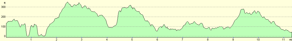
For more information on profiles, ascents and descents, see this page
Accommodation
I stayed at the Minch View B&B, Scouriemore, Scourie, By Lairg, Sutherland, NG7 4TG, Telephone 01971 502010. This was a nice little B&B that had some magnificent views. It cost nineteen pounds per night, and a twin room cost me no extra, although it may do in season.
There are also many other B&B's to stay in in Scourie, a hotel and a beautifully situated campsite.
Disclaimer
Please note that I take no responsibility for anything that may happen when following these directions. If you intend to follow this route, then please use the relevant maps and check the route out before you go out. As always when walking, use common sense and you should be fine.
If you find any information on any of these routes that is inaccurate, or you wish to add anything, then please email me.
All images on this site are © of the author. Any reproduction, retransmissions, or republication of all or part of any document found on this site is expressly prohibited, unless the author has explicitly granted its prior written consent to so reproduce, retransmit, or republish the material. All other rights reserved.
Although this site includes links providing convenient direct access to other Internet sites, I do not endorse, approve, certify or make warranties or representations as to the accuracy of the information on these sites.
And finally, enjoy your walking!
This walk was mentioned in the following routes:
| My sectional Land's End to John O'Groats walk |
Nearby walks
| # | Title | Walk length (miles) |
|---|---|---|
| 198 | Inchnadamph to Kylesku | 10.2 |
| 200 | Scouriemore to Rhiconich | 11.0 |
| 520 | Clachnessie to Duartbeg via Kylesku | 23.1 |
|
|

|