Walk #520: Clachnessie to Duartbeg via Kylesku
 |
 |
|
General Data
| Date Walked | 06/08/2003 |
| County | Highlands |
| Start Location | Clashnessie |
| End Location | Duartbeg |
| Start time | 07.38 |
| End time | 16.41 |
| Distance | 23.1 miles |
| Description | This was a long plod, mainly along roads, with some superb views to be had over the surrounding mountains and lochs. |
| Pack | Today I carried my 30-litre Karrimor HotRock rucksack, which was filled with my packed lunch, waterproof leggings, water bottle and a couple of spare shirts, together with the usual assortment of odds and ends. |
| Condition | I feel absolutely fine after this walk, and I could easily have walked further if I had needed to. My neck and shoulder were fine again, which is a good sign. |
| Weather | It was another hot day today, although there was a slight breeze that cooled me down when I was exposed to it. There was hardly any cloud at all during the day, and absolutely no sign of any rain. |
| OS map | Landranger number 15 (Loch Assynt, Lochinver & Kylesku) and Landranger number 9 (Cape Wrath, Durness & Scourie) |
 |
 |
|
 |
 |
|
Map of the walk
Maps courtesy of Google Maps. Route for indicative purposes only, and may have been plotted after the walk. Please let me have comments on what you think of this new format. For a detailed table of timings for this walk, please see the table file.
 |
 |
|
Notes
After the heat of yesterday, I thought that an early start may be the order of the day so that I could get a decent mileage done before it got too hot. Perversely, I got the best night's sleep that I had for some time, and I slept in for about an hour longer than I wanted. This led me to rushing around Mervan like a headless chicken getting my kit ready for the walk, and I set off about half an hour later than I wanted.
It was quite cool when I set off, and I made good time as far as the viewpoint in Drumbeg where I had arranged to meet Sam for breakfast. By the time I got there I was desperately in need of the toilet, and so as soon as I arrived at Mervan I took my rucksack off and sprinted down a little hill to the public conveniences. When I got there I could not find the correct door for the gents, and I ran round the building twice before realising it was right where I had first arrived at the building!
The rest of the walk along the B869 was nice, and even the steep ascents were not too tiring as they were not sustained for long and I could just stride up them. Some of the views were absolutely superb, and I stopped occasionally so that I could just stare at them. Unfort8unately despite it being a sunny day it was quite hazy, and although I passed very close to Quinag I could not really get any decent photographs of it until I got very close to it - the sky was just too hazy. In Unapool I nipped into a little cafe and shop there, and the shopkeeper remembered me from when I had gone in there for a coffee fifteen months before on my last trip!
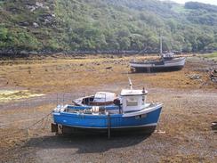
As I walked down the minor road into Kylesku I could see Mervan parked up near the jetty, and as I approached Sam came out to greet me. We had arranged that instead of having sandwiches for lunch we would eat something in the Kylesku Hotel, which I remembered from my last visit served lovely food. Due to the heat I chose not to have any alcohol and instead chose some orange and lemonade, a wise choice as it would not dehydrate me when I resumed the walk in the afternoon heat. We both ordered scampi and chips, and I ravenously wolfed it down in short order.
Sam had booked into a caravan site in Scourie, and although when I was planning the walk I had reckoned on spending the night in Kylesku I felt it best to move on. I still felt exceedingly fit, and indeed I hardly felt as though I had done sixteen miles in the morning, and so I decided to walk on beyond the village. I knew that this would make it he longest day for some weeks, but as I was feeling good I decided that it did not matter.
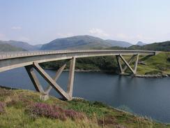
I took a little path that rises up from behind the hotel to reach the top of the bridge, and I then walked over the fascinating structure. I normally despise concrete bridges as they have none of the soul or panache of steel or stone structures, but this bridge is something that I rarely say about concrete structures - elegant. The bridge is built on a slight curve that is very pleasing to the eye, and the supports on either side are built in a nice 'V' shape. The bridge was built in 1982 and replaced the ferry that used to leave from the jetty outside the hotel, and it won awards for its construction.
I had walked the next section of road, northwest along the A894, before, and I enjoyed the stroll immensely. The road was not too busy, but none of the gradients were too steep and there were some nice views available. I was in a good mood, which always helps, but the miles just seemed to melt away under my feet and I soon found myself with a junction with the old road. This leads down in a sweeping curve through Duartbeg, and although it is possible to get vehicles up and down the first and last sections, the middle section is exceedingly overgrown. There is a path - just - through the undergrowth, and I felt like David Bellamy as I forced my way through the vegetation. It is amazing how stretches of this road have been overgrown by the vegetation, and it makes me wonder how quickly the world that we know would become overgrown if we all disappeared.
Sam met me at Duartbeg and we walked back to the A894 road, where Sam had parked Mervan. The drive to the campsite in Scourie was along a road that I had walked before, and I enjoyed seeing some of the scenery again - especially as I will be walking it tomorrow morning. Sam had bought some beers for us, and so we had an evening when not much was done - but before we both got too drunk Sam shaved my head using he new shaver that we bought in Ullapool.
Tomorrow I have got the last four miles to walk to get to Scourie, and after that I plan to walk on as far as Rhiconich. I could just walk along he A894, as I did last year when I walked from Scourie to Rhiconich, but instead I quite fancy taking a path northwards to Tarbet, and then follow roads eastwards to Laxford Bridge and Rhiconich.
Directions
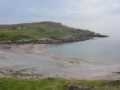
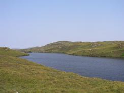
This walk starts off at the car park beside the beach in Clashnessie. Leave the car park and turn right to follow the B869 as it follows the coast eastwards, passing through Drumbeg and Nedd until it ends at a junction with the A894 road after fourteen miles. The road was narrow in places but it was not too busy, and although it is steep in places none of these steep sections were too prolonged. There are many nice views from the road out over the surrounding moorland and sea lochs.
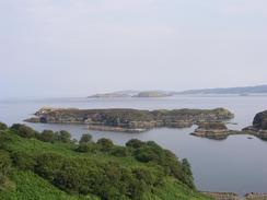
Once the junction with the A894 is reached turn left and follow the road for two miles northwards through Unapool and onwards as it descends down towards Kylesku. AT a junction on the right turn right down a minor road that leads for a couple of hundred yards into Kylesku. When the road ends by the Kylesku Hotel turn left up a footpath that climbs up some steps between the hotel and the sea. This path leads on and joins the A894 road once more on the southern side of the Kylesku Bridge. Cross the bridge, and on the other side it crosses the island of Garbh Eilean before descending to a causeway that is near to sea level. Once the causeway has been crossed it starts to rise steeply past the access road to Kylestrome until a summit is reached at a car park and viewpoint near Loch Dubh a' Chnoic Ghairbh.
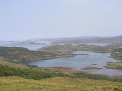
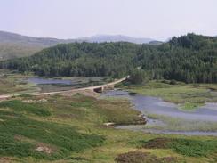
The road then settles into a north- northwesterly heading as it enters a wooded area. It passes the entrance road to Duartmore Bridge on the right before descending to a causeway that crosses the middle of Loch Duartmore. The road then starts to climb through a cutting, passing another access track to Duartmore Bridge, and then heads north-westwards immediately to the east of the 176-metre summit of Cnoc Chalbha.
Shortly after the road swings around to a westerly heading a track leads off to the left. A gate that proclaims that no unauthorised vehicles are allowed guards this, but walkers are fine. Go down this track that is surfaced as it crosses over the Allt an t-Srathain and then follows the beck down to a lovely narrow-sided bay in the sea.
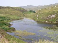
At the bay a path leads up the old road to the right, through a gate with a very narrow clapper gate beside it. Follow this very overgrown road as it heads northwestwards for about a kilometre, passing above Loch Duartbeg until it ends at a road near Duartbeg. Head up this road for about a kilometre until it reaches a junction with the A894 road; this walk ends at this junction.
Distances
| From | To | Distance (m) | Ascent (ft) | Descent (ft) |
|---|---|---|---|---|
| Clashnessie | Kylesku | 16.2 | 2910 | 2887 |
| Kylesku | Clashnessie | 6.9 | 1375 | 1260 |
This makes a total distance of 23.1 miles, with 4285 feet of ascent and 4147 feet of descent.
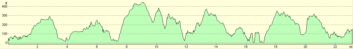
For more information on profiles, ascents and descents, see this page
Accommodation
We spent the night at the Scourie Camping Park, Harbour Road, Scourie, Lairg, Sutherland, Highlands IV27 4TG, telephone (01971) 502060. This site was very busy when we visited it and thus the toilets were not as clean as they could have been, but aside from this it was a nice site, which cost us eleven pounds for the night.
Disclaimer
Please note that I take no responsibility for anything that may happen when following these directions. If you intend to follow this route, then please use the relevant maps and check the route out before you go out. As always when walking, use common sense and you should be fine.
If you find any information on any of these routes that is inaccurate, or you wish to add anything, then please email me.
All images on this site are © of the author. Any reproduction, retransmissions, or republication of all or part of any document found on this site is expressly prohibited, unless the author has explicitly granted its prior written consent to so reproduce, retransmit, or republish the material. All other rights reserved.
Although this site includes links providing convenient direct access to other Internet sites, I do not endorse, approve, certify or make warranties or representations as to the accuracy of the information on these sites.
And finally, enjoy your walking!
This walk was mentioned in the following routes:
| My walk around the coastline of Britain |
Nearby walks
| # | Title | Walk length (miles) |
|---|---|---|
| 197 | Oykel Bridge to Inchnadamph | 18.2 |
| 198 | Inchnadamph to Kylesku | 10.2 |
| 199 | Kylesku to Scourie | 11.3 |
|
|

|