Walk #270: Brightlingsea to Fingringhoe
 |
 |
|
General Data
| Date Walked | 18/11/2002 |
| County | Essex |
| Start Location | Brightlingsea |
| End Location | Fingringhoe |
| Start time | 08.05 |
| End time | 14.21 |
| Distance | 15.2 miles |
| Description | This was a nice walk following river banks up towards Colchester and then partially back down the other bank. |
| Pack | Today I carried my 30-litre Karrimor HotRock rucksack, which was filled with my packed lunch, waterproof leggings, water bottle and a couple of spare shirts, together with the usual assortment of odds and ends. |
| Condition | I feel absolutely fine after this walk, and have no major problems to report aside from a little chaffing. My feet fely absolitely fine all day, and yet again I have no blisters. |
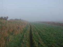
| Weather | The predominate factor about today's weather was the fog, which remained present all day. At times the sun appeared through the fog, but it never lifted substantially through the day. This made the day rather dark and unappealing, although it was actually quite mild and I was quite warm once the early morning chill had disappeared. |
| OS map | Landranger number 168 (Colchester, Halstead & Maldon) |
 |
 |
|
 |
 |
|
Map of the walk
Maps courtesy of Google Maps. Route for indicative purposes only, and may have been plotted after the walk. Please let me have comments on what you think of this new format. For a detailed table of timings for this walk, please see the table file.
Notes
At the northern side of the ford over Alresford Creek I stopped for a few minutes and had a chat to a man who was carrying a tripod. I initially stopped so that I could enquire whether it was possible to cross the ford at all, but we ended up chatting about other things as well. Apparently the ford can still be crossed at low water if you have Wellington boots, but it is very muddy. At very low tides you used to be able to walk up the middle of the creek for a short distance but since the railway line closed this has no longer been possible. Near the ford was an old staithe-like structure in the river, and on the bank next to it was a set of wheels on a stand. Looking around, I could see more of these wheels going off to my right towards a quarry, and it became obvious that this was part of an old system where boats were filled up with sand from the quarry. As is sometimes the case the industrial remains seemed quite proud and even elegant in their rusting decay, although I would not have minded seeing them working in their heyday.
The worst bit of today's walk was the short section down the B1029 road from Brightlingsea church to the junction with the footpath that leads down to the tidal mill. This was along a road that was very busy, and I had to walk very carefully along the windy road. Annoyingly a footpath and cycleway is being constructed along this section of road and some of it was nearly completed, but the section along the worst it of road was still unfinished which meant that I had to walk along the road. Hopefully by the time anyone else walks along this route it shall be finished, as this was one of the worst sections of road that I have had to walk along so far on this trip.
Just before I reached Wivenhoe I came cross a large structure that was not marked on my OS map. This is the Colne River Barrage, and if it had been closed would be the first possible crossing of the river and would have saved me a fair few miles walking. However like many of these structures even if it was closed it is not open to the public. I am quite intrigued as to why it is not marked on the map whereas the control building beside it is. It made me wonder about how often it is opened and shut, and how often they have to shut it because of a real potential flood situation t=rather than just as a test of the systems.
I stopped off for a quick drink in a pub near the church in Wivenhoe, and I was contemplating ordering some food when Mike rang. It sounded as if he was in a hurry for me to finish, so I decided against eating because it would take too long for the food to arrive.
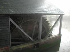
On the outskirts of Fingringhoe I passed another tidal mill, this one on the Roman River. This mill was originally a 16th century tidal mill, but was converted to steam in the 1800's and remained in operation until the mid 1990's producing cooked flaked maize. It is now private residences, and although the building has been very sympathetically altered I still think it is a shame that it is not being used for its original purpose.
Directions
This walk stars off at a car park in the south of Brightlingsea. Walk to the seafront and follow it around towards the tower at Westmarsh Point. Here a sea bank can be joined which makes for an easy couple of miles as it heads northwestwards, passing Aldboro Point before it reaches the edge of Alresford Creek. Here the path turns to the right to follow the southern bank of Alresford Creek eastwards for a few hundred yards until the old ford across the creek is reached.
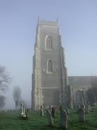
At the ford turn right and follow a bridleway that heads southwards along a track. This slowly winds its way to head southeastwards before eventually becoming a surfaced public road. Continue on along this road until it ends at a T-junction with the B1029 road beside a lovely church. Turn left to follow the B1029 road as it heads downhill to the northeast, passing Gatehouse Farm on the way. At the bottom of the hill a footpath leads off to the left along a track that leads to an old tidal mill. Cross Alresford Creek at this mill and then turn left to follow a footpath along the northern riverbank of Alresford Creek.
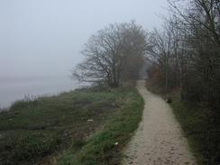
Continue on along the bank as it passes the ford and reaches the mouth of the creek, where it joins the River Colne. Here the path slowly turns to the right past Alresford Lodge to head northwestwards along an old railway embankment. After about a kilometre the path leaves the old railway line and heads off beside the river to the left. It passes the site of the Colne barrage and passes through a derelict industrial area before entering Wivenhoe. Head through Wivenhoe, passing the church and joining the B1028 towards the station. Head through the station car park and join a footpath that heads beside the railway line as it heads northwards. This footpath is part of a National Cycle Network path, and continues north-westwards beside the railway line for a couple of miles until it reaches the first bridge over the River Colne at The Hythe.
Turn left and cross over the bridge to a roundabout on the western side of the bridge. At the roundabout turn left and follow the road as it heads southeastwards through an industrial area. When the road ends turn left to join the riverbank once more. Turn to the right and follow the riverbank as it heads southeastwards along the western bank of the Colne before it eventually enters Rowhedge. The path ends at a road in the village, and follow this road beside the river through the village. When the road ends at a factory on the southern edge of the village turn right to head southwestwards along another path. This path ends at a bridge over another creek, which can be crossed using a bridge beside an old mill. On the other side of he bridge a track leads uphill to the south before ending a short distance later at a road. At this road turn right and follow it for a few hundred yards to Fingringhoe church, where this walk ends.
Distances
| From | To | Distance (m) | Ascent (ft) | Descent (ft) |
|---|---|---|---|---|
| Brightlingsea | Wivenhoe | 9.5 | 285 | 266 |
| Wivenhoe | Fingringhoe | 5.7 | 240 | 203 |
This makes a total distance of 15.2 miles, with 525 feet of ascent and 469 feet of descent.
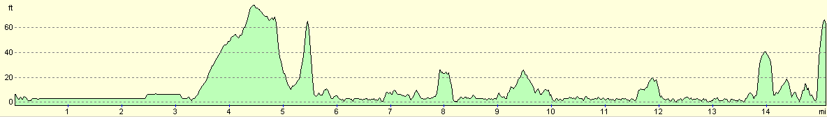
For more information on profiles, ascents and descents, see this page
Accommodation
We stayed at the Colchester Caravan and Camping park, Cymbeline Way, Lexden, Colchester, Essex CO3 4AG, at grid reference 968255. They have a website at www.colchestercampng.co.uk and can be contacted by phone on 01206 545551. This was probably the most complete site I have stayed on for some time, and was very professionally run, clean and tidy. It cost us twelve pounds per night for our pitch, which was very good value.
Disclaimer
Please note that I take no responsibility for anything that may happen when following these directions. If you intend to follow this route, then please use the relevant maps and check the route out before you go out. As always when walking, use common sense and you should be fine.
If you find any information on any of these routes that is inaccurate, or you wish to add anything, then please email me.
All images on this site are © of the author. Any reproduction, retransmissions, or republication of all or part of any document found on this site is expressly prohibited, unless the author has explicitly granted its prior written consent to so reproduce, retransmit, or republish the material. All other rights reserved.
Although this site includes links providing convenient direct access to other Internet sites, I do not endorse, approve, certify or make warranties or representations as to the accuracy of the information on these sites.
And finally, enjoy your walking!
This walk was mentioned in the following routes:
| My walk around the coastline of Britain |
Nearby walks
| # | Title | Walk length (miles) |
|---|---|---|
| 268 | Great Oakley Hall to Clacton-on-Sea | 17.9 |
| 269 | Clacton-on-Sea to Brightlingsea | 18.8 |
| 271 | Fingringhoe to Tollesbury | 16.7 |
|
|

|