Walk #268: Great Oakley Hall to Clacton-on-Sea
 |
 |
|
General Data
| Date Walked | 16/11/2002 |
| County | Essex |
| Start Location | Great Oakley Hall |
| End Location | Clacton-on-Sea |
| Start time | 08.26 |
| End time | 15.27 |
| Distance | 17.9 miles |
| Description | This was a walk of two halves; an initial section to Walton-on-the-Naze took me along roads and sea banks, and the second half took me along promenades and seawalls southwestwards to the pier at Clacton-on-Sea. |
| Pack | Today I carried my 30-litre Karrimor HotRock rucksack, which was filled with my packed lunch, waterproof leggings, water bottle and a couple of spare shirts, together with the usual assortment of odds and ends. |
| Condition | I had one problem today, and that was with my feet. My boats got soaked early on in the day in a large, muddy area of path, and the long grass on the sea walls did not ease matters. This meant that when I was walking along the hard, concrete seawalls southwestwards from Walton-on-the-Naze my feet took a pounding, and my toes ached at the end of the walk. This could be due to a combination of the length of the toenails coupled with the wet feet, so I have cut my toenails to see if that will help tomorrow. Aside from this I was more fatigued than I should have been after this walk, which is slightly worrying as I should have been able to pile the miles on in such lovely weather. |
| Weather | The weather today was absolutely superb, with a nice sunny sky remaining with me for all of the day, and only a few clouds popped along to try and spoil it for me. There was little wind and it was a mild day anyway, so I never at any time felt chilled and indeed at times I felt too warm. |
| OS map | Landranger number 169 (Ipswich & The Naze, Clacton-on-sea) |
 |
 |
|
 |
 |
|
Map of the walk
Maps courtesy of Google Maps. Route for indicative purposes only, and may have been plotted after the walk. Please let me have comments on what you think of this new format. For a detailed table of timings for this walk, please see the table file.
 |
 |
|
Notes
As I was walking down towards Beaumont Quay I left the fields and entered the farmyard of a farm beside the quay. In the yard was a man on a bicycle, and we started chatting about the walk that I was doing. He asked me what my girlfriend was doing all day whilst I was walking, and I replied that She was Australian and therefore se spent much time exploring the towns and villages along the route. Suddenly he looked at me in a questioning way and asked, "Is she Sam Green?". This totally flabbergasted me, as to the best of my knowledge we had never met this man before. I said that she was, and the man started laughing. Apparently Sam had booked into the small caravan site at this farm for last night and had not cancelled when we went elsewhere. The man had left a note out for us once it had gone dark telling us where to park, and he showed us the note still visible in the courtyard. I apologised profusely, and he rather nicely said that it had made his day. He was a very nice chap, and actually invited me in for a cup of coffee, but I had to decline as I had a long way to go still. What are the odds of the campsite being on my route, the man being in the farmyard and of us chatting enough for him to realise that I knew Sam?
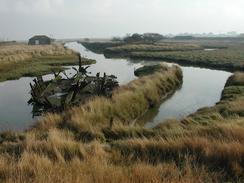
He also told me that the stones in the quay were actually from the original London Bridge. All the land around here had been owned by Guys Hospital, and boats used to sail from here down to London. Some of these boats bought back with them stones from the bridge with which to build the quay. The river leading up to the way is also quite interesting; it is quite winding and tight in places, so Dutchmen built a canal right up to the quay. Traces of this canal still exist and it is a much straighter route than the river, although the canal has been cut off in a couple of places by the sea defences. I can only imagine how hard it must have been to dig a channel through marshland which is inundated by the sea twice every day, and without using modern machinery. In the quay itself was the remains of an old wooden boat, slowly rotting into nothing.
It was very much a day of meeting people, and the fact that I stopped every so often to chat to people made the walk much slower than it should otherwise have been. The weather certainly helped me walk slower, as the last thing that I felt like doing in such lovely sunshine was rushing. When I got to Frinton I decided to stop to eat my lunch. Before I sat down I went up to the sea wall to take a picture when I heard a voice behind me. I turned around, and the couple I met last Saturday at Orford were there. The man had been reading my website since we last met, and we chatted away for five minutes before I finally got to sit down by the beach huts and ravenously ate my sandwiches.
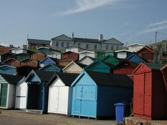
Perhaps the most amazing thing for me about Walton and Frinton were all the beach huts. As I walked along the sea wall between these two towns the beach huts were stacked up sometimes four deep away from the wall. They were all various colours, from sky blue to creosote to light yellow, and I could not believe how many of them there were. It made me wonder how much more expensive a hut right next to the wall (with easiest access to the beach) is to one of the ones further up the slope where you would have to walk past al the other huts to get to the sea. Frinton -on-Sea is, for me, immortalised as 'bloody Frinton' in a sketch by Dudley Moore and Peter Cook, and I found it very hard not to burst out shouting that as I walked along past all the huts. To be fair, I did not see much of Frinton as I did not walk along the cliff tops but kept going along the seawall, so it could be quite a nice town, but to me it will always be associated with all those beach huts.
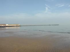
Sam left me today to go scuba diving in the Red Sea, so when I got to Clacton I received a phone call from Mike, a friend of mine from my university years in London. Mike is very kindly stepping in for a few days, driving the van to drop me off and pick me up each day. I met Mike at the seafront near he pier, and we continued on down to the pier where I finished my walk before finding a fish and chip shop to get some early dinner which we ate as we made our way back to the van. In some ways it is nice to have another person around, but I am already missing Sam a great deal.
As of today I have reached the 800-mile barrier on the walk, which is a quite satisfying feeling. I am starting to get impatient to reach the 1,000-mile barrier, which I should reach within a couple of weeks, and just before I reach London. Before then I have much walking up and down river estuaries to do, as the Essex coastline is far from straight, although it is thankfully mostly flat.
Directions
This walk starts off at the entrance to the driveway leading to Great Oakley Hall, which is about a mile to the east of the village of Great Oakley. Leave the hall and head westwards along the B1414 road into the village. By the war memorial turn left down a road for a short distance southeastwards towards Mosses Farm. By the farm follow the road as it turns abruptly to the right for a few yards until a footpath heading off to the left opposite a cottage is reached.
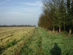
Turn left and follow the footpath across fields until it ends at the B1414 road near to Moze Cross. Turn left down the B1414 and follow it as it almost immediately turns sharply to the right to head southwestwards. Continue on along the road and after a little more than a mile take the second footpath to the left. This footpath descends downhill before curving to head in a southwards direction across fields before ending at a farm. Go through the farmyard and join a track that heads southwards for a short distance until it ends. At the end of the track take a footpath that leads slightly to the left before ending at Beaumot Quay.
At the quay climb up onto the bank and follow it as it heads eastwards past Landermere Quay. It continues winding on past Skipper's Island before turning southwards towards the village of Kirby-le-Soken. The path leaves the bank immediately to the north of the village and enters a muddy field before reaching a road. Continue on down this road until the B1034 road is met in the village.
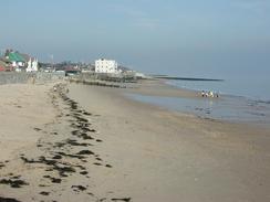
Turn left and follow the B1034 eastwards out of the village for a couple of miles towards Walton-on-the-Naze. The road passes the church in the town before meeting the seafront next to the tourist information office. Leave the road here and turn right to follow another road southwards to the pier. At the pier drop down to walk along the promenade, which continues on past lines of multicoloured beach huts out of the town and into Frinton-on-Sea, although at the level of the promenade it is hard to see where Walton-on-the-Naze ends and Frinton-on-sea begins.
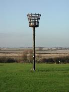
Continue on along the sea wall southeastwards out of the town. When the last line of beach huts ends a sea wall continues on to the southeast, squeezing between the sea and a golf course before reaching a large aerial immediately outside Holland-on-Sea after a couple of miles. Here you can choose to walk along the lower seawall or to climb up, and walk along the road at the top of the cliffs as I did. Follow the road as it heads southwestwards passing through Holland-on-sea before entering Clacton-on-Sea and reaching the pier, where this walk ends.
Distances
| From | To | Distance (m) | Ascent (ft) | Descent (ft) |
|---|---|---|---|---|
| Great Oakley Hall | Walton-on-the-Naze | 11.2 | 230 | 279 |
| Walton-on-the-Naze | Clacton-on-Sea | 6.7 | 341 | 335 |
This makes a total distance of 17.9 miles, with 571 feet of ascent and 614 feet of descent.
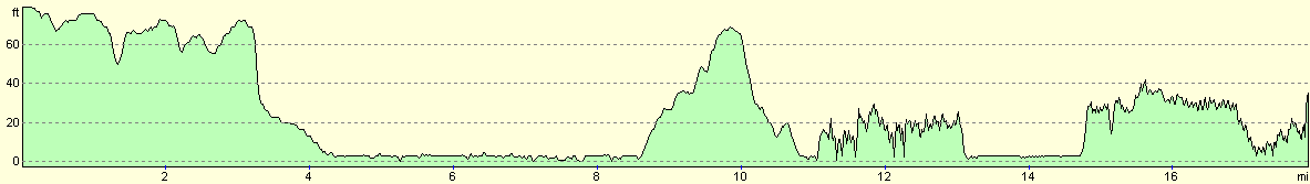
For more information on profiles, ascents and descents, see this page
Accommodation
We spent a second night at Grange Farm, OS Field 221 a/b, Thorp-le-Soken, Clacton, Essex CO16 oHG. They can be contacted on 01255 861208. This site cost us ten pounds for two nights, and the shower tokens cost fifty pence per token, and one token lasts for about six minutes. This was a nice little farm site, and has six horses and a psycho dog.
Disclaimer
Please note that I take no responsibility for anything that may happen when following these directions. If you intend to follow this route, then please use the relevant maps and check the route out before you go out. As always when walking, use common sense and you should be fine.
If you find any information on any of these routes that is inaccurate, or you wish to add anything, then please email me.
All images on this site are © of the author. Any reproduction, retransmissions, or republication of all or part of any document found on this site is expressly prohibited, unless the author has explicitly granted its prior written consent to so reproduce, retransmit, or republish the material. All other rights reserved.
Although this site includes links providing convenient direct access to other Internet sites, I do not endorse, approve, certify or make warranties or representations as to the accuracy of the information on these sites.
And finally, enjoy your walking!
This walk was mentioned in the following routes:
| My walk around the coastline of Britain |
Nearby walks
| # | Title | Walk length (miles) |
|---|---|---|
| 264 | Waldringfield to Nacton via Felixstowe | 19.6 |
| 265 | Nacton Church to Shotley Gate | 14.2 |
| 266 | Shotley Gate to Mistley | 14.2 |
|
|

|