Walk #265: Nacton Church to Shotley Gate
 |
 |
|
General Data
| Date Walked | 13/11/2002 |
| County | Suffolk |
| Start Location | Nacton Church |
| End Location | Shotley Gate |
| Start time | 08.40 |
| End time | 14.00 |
| Distance | 14.2 miles |
| Description | This was a nice walk over the large and imposing Orwell Bridge and back down the southern bank of the River Orwell |
| Pack | Today I carried my 30-litre Karrimor HotRock rucksack, which was filled with my packed lunch, waterproof leggings, water bottle and a couple of spare shirts, together with the usual assortment of odds and ends. |
| Condition | I feel absolutely fine after this walk, and I have no problem to report. |
| Weather | Again the weather forecast for today was for heavy rain, and this was the situation through the night. I delayed the start this morning in case the rain stopped, and fortunately it did. There was a little rain in the air for the first hour or so, but this was light and it soon ended. The rest of the day was mainly sunshine and cloud, although some of these clouds were very black. It was a mild day, and this coupled with a lack of much wind caused me to overheat at times. |
| OS map | Landranger number 169 (Ipswich & The Naze, Clacton-on-sea) |
 |
 |
|
 |
 |
|
Map of the walk
Maps courtesy of Google Maps. Route for indicative purposes only, and may have been plotted after the walk. Please let me have comments on what you think of this new format. For a detailed table of timings for this walk, please see the table file.
Notes
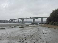
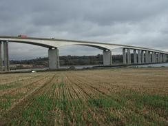
The highlight of the day (both literally and figuratively) was the crossing of the River Orwell on the Orwell Bridge, which carries the A14 road over the river. This is a surprisingly elegant concrete bridge, and is 1,287 metres long and stands 39 metres above the high water mark. When it opened in 1982 it was one of the ten longest structures in the world. When I was walking across it I was surprised to find a Samaritans phone on the end of it, a sad sign of how many people have jumped off the bridge. Every so often on the bridge parapet there was a little metal sign pointing towards the phone at each end, which was a poignant sight. As I approached the crest of the bridge I saw a ship come under it downstream, which was a lovely sight.
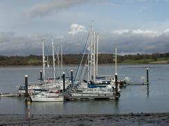
I stopped off for a bite of lunch at Pin Mill, where I sat on a bench in front of a slightly waterlogged grassy area. It was nice sitting looking at the boats on the river, with others in the boatyards to the left, watching people pass by. There was a dog which came up and nosed around me for a while, probably hoping for a bite of my sandwiches which I sadly had to decline as I was ravenous.
I have an ex-colleague who lives in Ipswich and so we arranged to meet up in the Pin Mill Inn for a drink this evening. I have been having really bad sleeping patterns recently, and last night I went to bed at eight in the evening and this morning I got up at four. To try and get out of this pattern I decided to go to bed late tonight, so that I will hopefully wake up later tomorrow morning. Unfortunately this did not happen, and I woke up at five in the morning after going to bed at eleven last night. The trip to the pub was enjoyable - the Butt and Oyster is a nice little pub, and I had four pints of Abbott before Paul and Tracey gave us a lift back up the hill to our van. Apparently at high tide sailors can moor outside the pub and get drinks without stepping off their boats!
Tomorrow I shall be leaving Suffolk and entering Essex, which will be a nice feeling. I have enjoyed walking through Suffolk as it is a very nice county, but finishing the county means that I am a little bit nearer the finish. Suffolk has been a county with many river estuaries to be crossed, and this has meant that I have walked much further than the basic distance around the coastline requires. Essex will be very much the same, with many estuaries to be crossed.
Directions
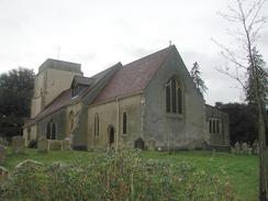
This walk starts off outside the church at Nacton. Turn left to head northwestwards up a road for a short distance until it ends at a T-junction. At the junction turn left and follow this road as it heads northwestwards for a mile until it reached a roundabout beside the A14. Continue straight on, passing under the A14 and over another roundabout to head northwestwards up the A1189.
Take the first road to the left, which is signposted for a country park, and follow this narrow road as it heads for a kilometre before turning sharply to the left to cross over the A14 on a bridge. Immediately on the southern side of the bridge turn right down another road which leads past a car park and picnic area until it ends at the entrance to the country park.
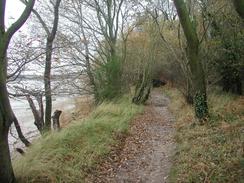
At the end of the surfaced road turn right down a track for a short distance and then turn left down a track that heads downhill along a very rough track through the trees. Just before the track enters a farmyard turn left through a gate and follow a path uphill before it turns to the right and descends down to the side of the river. At the river turn right and follow a path that heads upstream along the edge of the river with the Orwell Bridge clearly visible ahead.
Continue on as the path exits the woodland until a track leads off to the right towards Hall Farm. Take this path and follow it uphill until a T-junction is reached. At the junction turn left down a track and follow it past the farm and onwards until it turns to the right. At this point head straight on along another track to the eastern abutment of the Orwell Bridge.
At the abutment climb up some steep steps onto the bridge and then turn left to cross the bridge using the footpath provided. On the other side of the bridge descend down some rough grassy steps before joining a footpath that leads southeastwards across a field to a track. Cross over this track and continue southeastwards across fields until it meets the B1456 road. Turn right for a few yards along the road and then turn right down another footpath that heads uphill beside a hedge, with the road on the other side of the hedge.
When this footpath ends at the road turn right down the road and follow it uphill into Freston along a pavement. When The Boot pub is reached turn left down a footpath for a short distance until it meets a track. At the track turn right and follow it as it curves around to head eastwards. When the track ends near Home Farm continue on along a footpath that crosses a road before reaching a playing field. Cross the playing field and head towards the church.
When the church is reached turn left along a footpath that heads into some woodland and heads downhill before entering the grounds of a marina by the river. Turn right along another footpath that heads across a boggy area of ground before reaching the boatyard at Pin Mill. In Pin Mill continue on towards the Butt and Oyster pub and then turn right to head uphill along a road. Pass a car park and picnic area on the right before turning left along another footpath that heads up some steps.
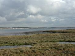
The path then heads eastwards through a nice area of woodland at the top of the cliff for a little under a mile before descending down to the level of the river once more at Clamp House. The path then continues on eastwards (this section of path is not marked on my OS map but is very clear on the ground and is waymarked). It passes to the right of some marshland before emerging onto the seawall, which is followed until Collimer Point is reached.
At Collimer Point the path and river turn to the right to take a more southerly heading for a couple of miles until the marina at Shotley Point is reached. At the marina turn left and take the seawall which lies between the marina and the sea past the marina towards it's entrance, where there are some lock gates that can be used to get onto the other side, where there is a control tower for the gates. On the other side continue on along the top of the seawall as it curves around to a more westerly heading towards some piers. The walk ended here, as there was plenty of room for Sam to park the van.
Distances
| From | To | Distance (m) | Ascent (ft) | Descent (ft) |
|---|---|---|---|---|
| Nacton Church | Orwell Bridge | 3.8 | 144 | 217 |
| Orwell Bridge | Pin Mill | 4.8 | 262 | 230 |
| Pin Mill | Shotley Gate | 5.6 | 233 | 249 |
This makes a total distance of 14.2 miles, with 639 feet of ascent and 696 feet of descent.
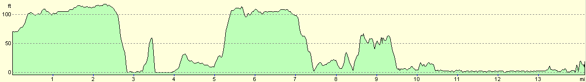
For more information on profiles, ascents and descents, see this page
Accommodation
We spent the night in the village car park in Chelmondiston which is beside the Chelmondiston pub. This allowed us to have a drink and stagger back to the van tonight. It also saves us the site fees for the night.
Disclaimer
Please note that I take no responsibility for anything that may happen when following these directions. If you intend to follow this route, then please use the relevant maps and check the route out before you go out. As always when walking, use common sense and you should be fine.
If you find any information on any of these routes that is inaccurate, or you wish to add anything, then please email me.
All images on this site are © of the author. Any reproduction, retransmissions, or republication of all or part of any document found on this site is expressly prohibited, unless the author has explicitly granted its prior written consent to so reproduce, retransmit, or republish the material. All other rights reserved.
Although this site includes links providing convenient direct access to other Internet sites, I do not endorse, approve, certify or make warranties or representations as to the accuracy of the information on these sites.
And finally, enjoy your walking!
This walk was mentioned in the following routes:
| My walk around the coastline of Britain |
Nearby walks
| # | Title | Walk length (miles) |
|---|---|---|
| 107 | Stowmarket to Ipswich | 16.1 |
| 131 | Ipswich to Wickham Market Station | 16.7 |
| 263 | Bawdsey to Waldringfield | 17.9 |
|
|

|