Walk #264: Waldringfield to Nacton via Felixstowe
 |
 |
|
General Data
| Date Walked | 12/11/2002 |
| County | Suffolk |
| Start Location | Waldringfield |
| End Location | Nacton Church |
| Start time | 07.50 |
| End time | 16.00 |
| Distance | 19.6 miles |
| Description | This was a nice, long walk down the western bank of the Rive Deben to Felixstowe Ferry, along the seafront down to Felixstowe, and then up the eastern bank of the River Orwell to Nacton. Despite having walked nineteen miles, I am probably only five or six miles away from where I started the day. |
| Pack | Today I carried my 30-litre Karrimor HotRock rucksack, which was filled with my packed lunch, waterproof leggings, water bottle and a couple of spare shirts, together with the usual assortment of odds and ends. |
| Condition | I feel fine but slightly fatigued after this walk, with no real problems to report. |
| Weather | The rain was lashing down on the van when I woke up this morning, and the weather forecast was for heavy rain all day. It was therefore with a heavy heart that I set out into the rain. Fortunately during a period of about an hour the rain slowed down and then stopped, and I even started to see the sun trying to peek through the cloud overhead. Unfortunately the rain was replaced with a strong headwind, which was annoying if not troubling. By the time I reached Felixstowe the sun was out, but when I restarted the walk after my lunch break it was raining again. There then followed about ninety minutes of the hardest rain of the day, after which the sun came out enough to dry me out very quickly. It was also a quite mild day, and so all in all it cold have been much, much worse. |
| OS map | Landranger number 169 (Ipswich & The Naze, Clacton-on-sea) |
 |
 |
|
 |
 |
|
Map of the walk
Maps courtesy of Google Maps. Route for indicative purposes only, and may have been plotted after the walk. Please let me have comments on what you think of this new format. For a detailed table of timings for this walk, please see the table file.
 |
 |
|
 |
Notes
The rain was lashing down as I set off today, and I was all set for a really wed day. This did not happen, and much of the day was actually sunny and windy, which was a great relief. The wind was annoying on the section down to Felixstowe Ferry as it we very blustery and at times it was hard to keep my footing in the muddy areas of path at the top of the riverbank.
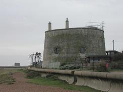
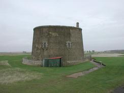
Felixstowe Ferry was a nice little place. This ferry travels across the river to Bawdsey Quay, making a very helpful route to those people walking the coast who do not want to walk up all the river estuaries. A ferry has operated from here since Norman times, and in the 1953 floods the village was flooded under five feet of water. Two Martello towers are nearby, guarding the mouth of the River Deben, but the second one only seems to be guarding a golf course nowadays. There is a little cafe in the village, and I was very tempted to go in and have a quick snack, but I had not yet eaten my sandwiches and so I felt that it was best to wait until after I had before snacking. I have already lost a significant amount of weight on the walk (I can tell because trousers which used to fit me are now very loose), and I want to remain thin or as long as I can. Eating lots of chocolate, crisps or greasy fry-ups may be nice, but hardly help me keep the weight off.
I must admit that I had never really thought of Felixstowe as being a holiday resort - in my mind it had always been synonymous with handling container ships. I was quite surprised to find that it was a half-decent little resort, although the beach was not one I would really want to play if I was a child, as it seemed to consist of the same red shingle that dominates the Suffolk Coast. The port itself was massive - the 13 metre deep water allows ships of up to 180 metres to dock, and the Trinity Container Terminal alone is the largest in the UK, handling over 120,000 containers per month. The growth of the town has been n stages - it was little more than a village until the railway arrived in 1877 and a resort was built. After the war the docks were developed and these now dominate the southern part of the town. From the riverbank near Trimley Marshes I could see long rows of cranes stretching off into the distance, many with containers stacked like Lego bricks underneath them. The whole area had been busy yet strangely ordered, and for some strange reason I found the sight quite attractive.
When I got to Felixstowe Sam was in the library checking our email accounts. I did not fancy walking all the way through town to meet her, so I nipped into the tourist information office and then went over the road to the Old Millars Bar and Restaurant and had a pint of Adnams whilst I waited. When she turned up she had a coffee and I had another pint while we discussed what our plans were for the rest of the day. It was hence in a slightly more intoxicated state that I set off on the afternoon's walk, and this soon showed through - when I got to a roundabout on the outskirts of Felixstowe I went down the wrong road, walking for a couple of hundred yards along the verge of a dual carriageway before realising that I was on the wrong road and had to turn back. In my defence I can partially blame the rain, which was preventing me from looking at my map as much as I would have liked to, but that is an easy excuse for what was a stupid mistake.
Just past Trimley Marshes I passed another area where an area of farmland had been purposefully flooded to allow salt marsh to be created. This involved another diversion, but this one was not too long and allowed me to see the birds on the newly created marshland. A while alter I came across the Suffolk Yacht Club which is to the west of Trimpley St Martin and was opened in 1970. This was full of yachts, with many out of the water being stored or worked on.
Before I started this trip I was expecting to hate all the river valleys that I am having to walk up. They cause me to walk long distances only to get a couple of miles from where I started, which can be soul destroying. I am surprised to find that (at the moment, at least) I am actually quite enjoying them. They give a slightly different flavour to the walk after many miles of walking beside the sea, and the countryside around the rivers tends to be more varied than that around the sea - particularly when I am walking along a beach and all I can see are the cliffs.
Tomorrow I have two choices - I can either shorten the walk by crossing over the River Orwell at the A14 Orwell Bridge, or I can walk into Ipswich and cross over the river there. Doing the latter will add five or six miles onto the walk, so I think that I will do the former, particularly as it is a valid route (a bridge that can be walked over). However I could do with visiting Ipswich and going into the town to buy some more walking kit (I am in need to some more base layer trousers and some other stuff), so I may see if Sam wants to meet me on the other side of the bridge and then we can drive in together. This may take too long out of my day, however, so I may just walk on towards Shotley Gate.
Directions
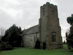
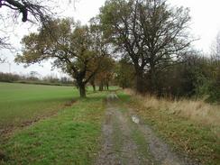
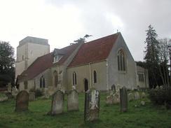
This walk starts off at the caravan site off Ipswich Road in Waldringfield. Leave the site and turn left to walk a short distance down Ipswich Road to a road junction. At the junction turn right to walk southwards through the village. Follow the road as it curves to the left and then take a road that leads off to the right. This road heads past Waldringfield Church and continues on southwards. When the road curves sharply to the right continue on uphill along a concrete track towards Helmey Hall. At the top of the hill the track ends and a bridleway heads off slightly to the left before meeting the end of a dead-end road. Continue on down this road to Hemley Church.
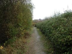
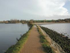
At the church turn left and then right southwards down a track. Follow this track as it turns to the left to head southeastwards across slightly wet and boggy ground until it ends at Kirton Creek. Skirt the western end of Kirton Creek and then turn left along the southern edge of the creek along a riverbank. The riverbank turns to head eastwards and then slowly curves around to a more southeasterly and then southerly heading as it approaches Falkenham Creek. The riverbank winds around the creek and continues on in a southeasterly direction. The path turns to the right to head past an inlet and then continues on with a large marshy area between the riverbank and the river to the left. About a kilometre further on another inlet is reached, and on the far side of this turn left along an uneven concrete seawall and follow this to the road in Felixstowe Ferry.
Cross the road in Felixstowe Ferry and go onto the beach. Turn right and walk along the beach, heading for the first Martello Tower. Under the tower join a sea wall and follow it southwards past a golf course and another Martello Tower. The seawall continues on in a southwesterly direction under Old Felixstowe towards Cobbolds Point. Before the point is reached the seawall ends and I had to continue along the beach for a short distance until the beach was blocked by some rock groynes. It may be possible to get around these at low tide; I decided to climb up some steps to the right that lead up onto the top of the cliffs. There then follows a short path that leads out onto Golf Road. Turn left down this road and follow it until it ends at Undercliff Road East. Turn left down this road and follow it as it swings around and down to join the beach once more. Once on the beach is met walk along either the road, the promenade or the beach westwards towards Felixstowe Pier.
Continue along the promenade past the pier until the Sea Road Car Park is reached on the left. At the car park turn right down Beach Station Road to some traffic lights. At the lights cross over the crossroads and continue up Walton Avenue until a large roundabout is reached. AT this roundabout take the second road to the right (essentially straight on). Do not take walk along the dual carriageway road as this is a very silly thing to do. Continue along this road with the docks to the left to another roundabout with Gate 2 off to the left. Continue straight on at this roundabout down another road and when this road curves to the right after a short distance continue on down a more minor road with the docks and some railway sidings to the left. At the end of this road turn left and carefully cross the railway sidings and once on the other side turn left along a footpath. This footpath rises up onto the top of Fagbury Cliff before descending and turning to the right to join a track with some farmland to the right.
A short distance after the bend turn left down another track which heads northwestwards with an earth bank to the left. The track curves to the left after about a kilometre and heads down to meet the riverbank at Trimley Marshes.
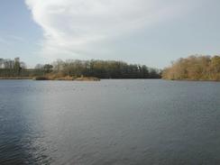
From the marshes turn right and follow the track as it heads past the visitors centre and some hides. Eventually the track peters out and the ground becomes boggy, so it may be best to follow the footpath at the top of the riverbank. There then follows an area where the riverbank has been breached to create a new area of salt marsh, so the footpath diverts along another bank around the new marsh. At the end of the area the path meets a narrow track and continues along this northwards towards Loompit Lake. At the lake the path turns to the right and continues along a narrow path between the river and the lake until near the end of the lake. It then turns to the right for a short distance and then turns left through a little area of woodland before reaching the Suffolk Yacht Club.
Go through the grounds of the yacht club until some chandlery shops are reached on the right. At these buildings turn right and then left to go along a track behind them and go over a stream. On the other side of the stream turn left to go back towards the riverbank. At the bank turn right and follow it as it curves around a creek with a marsh to the left. When the end of the creek is reached continue straight on up a track for a short distance until a road is met. At the road turn left and follow it past Levington Church out of the village. The road dips down into a valley, at the bottom of which a bridleway leads off to the left. Follow this bridleway as it heads through a wooded area and then climbs up before ending at a road. AT the road turn right and walk a short distance to Nacton Church.
Distances
| From | To | Distance (m) | Ascent (ft) | Descent (ft) |
|---|---|---|---|---|
| Waldringfield | Felixstowe Ferry | 7.3 | 164 | 230 |
| Felixstowe Ferry | Felixstowe Pier | 3.3 | 141 | 135 |
| Felixstowe Pier | Nacton Church | 9.0 | 325 | 266 |
This makes a total distance of 19.6 miles, with 630 feet of ascent and 631 feet of descent.
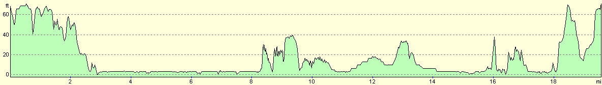
For more information on profiles, ascents and descents, see this page
Accommodation
We stayed at the Orwell Meadows Leisure Park, Priory Lane, Ipswich IP10 0JS. They can be contacted on (01473) 726666 or can be emailed at recept@orwellmeadows.co.uk. This site cost us twelve pounds and fifty pence for the night, and had some reasonably good facilities.
Disclaimer
Please note that I take no responsibility for anything that may happen when following these directions. If you intend to follow this route, then please use the relevant maps and check the route out before you go out. As always when walking, use common sense and you should be fine.
If you find any information on any of these routes that is inaccurate, or you wish to add anything, then please email me.
All images on this site are © of the author. Any reproduction, retransmissions, or republication of all or part of any document found on this site is expressly prohibited, unless the author has explicitly granted its prior written consent to so reproduce, retransmit, or republish the material. All other rights reserved.
Although this site includes links providing convenient direct access to other Internet sites, I do not endorse, approve, certify or make warranties or representations as to the accuracy of the information on these sites.
And finally, enjoy your walking!
This walk was mentioned in the following routes:
| My walk around the coastline of Britain |
Nearby walks
| # | Title | Walk length (miles) |
|---|---|---|
| 107 | Stowmarket to Ipswich | 16.1 |
| 131 | Ipswich to Wickham Market Station | 16.7 |
| 262 | Chillesford to Bawdsley | 10.8 |
|
|

|