Walk #289: Sittingbourne to Faversham
 |
 |
|
General Data
| Date Walked | 07/12/2002 |
| County | Kent |
| Start Location | Sittingbourne Station |
| End Location | Faversham Station |
| Start time | 08.07 |
| End time | 14.27 |
| Distance | 16.3 miles |
| Description | This was a nice walk following The Swale eastwards between the two towns. |
| Pack | Today I carried my 30-litre Karrimor HotRock rucksack, which was filled with my packed lunch, waterproof leggings, water bottle and a couple of spare shirts, together with the usual assortment of odds and ends. |
| Condition | I am absolutely fine after this walk, and have no major problems that I can report. My ankle is significantly better than it has been over the last couple of days, and it did not inconvenience me much. |
| Weather | The day started off bitterly cold and overcast. There was a slight breeze, which made matters worse when I was in exposed places. Fortunately there was not any real rain, but there were some slight drizzle showers during which I was fairly cold. |
| OS map | Landranger number 178 (Thames Estuary, Rochester & Southend-on-Sea) |
 |
 |
|
 |
 |
|
Map of the walk
Maps courtesy of Google Maps. Route for indicative purposes only, and may have been plotted after the walk. Please let me have comments on what you think of this new format. For a detailed table of timings for this walk, please see the table file.
 |
 |
|
Notes
It was a bitterly cold day today, and as I walked along the streets in Sittingbourne my hands grew increasingly cold and stiff despite the fact that I was wearing gloves. Fortunately after about an hour I started to warm up and I could take my gloves off (which I always hate wearing) and stuff them in my pockets.
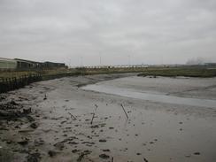
The Swale was the main feature of today's walk. This channel separates the mainland from the Isle of Sheppey, and at the start of the walk the tide was very high, making the channel a very wide expanse of water. Indeed in places it was only about a foot from the top of the flood banking, so I assume that it doe not normally get any higher than that.
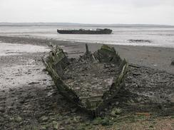
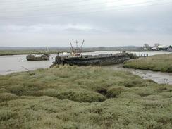
On a previous walk in the area I had met a man who worked in the paper mill, and he had told me that two boats in the mud were actually the remains of two second world war minesweepers, which had hulls built of wood so they would not attract magnetic mines. Unfortunately I have not been able to find out any more about these boats, information about minesweepers on the Internet being very sparse. On this trip the tide was much further out when I passed them, so I could see much more of them than I did on the previous trip.
I found the walk around the sea bank to be quite boring, so I started singing to while away the time. On the first day of the walk Sam and I altered 'And I would walk one hundred miles' by the Proclaimers to be 'And I would walk 5,500 miles...' which, whilst not being quite as catchy, is quite accurate or my walk. I started warbling out this tune and instantly a flock of sheep that had previously been watching me ran across to the other side of the field. I can therefore conclude that sheep are very good music critics.
As the day was progressing I realised that I had plenty of time left so I started to slow down and enjoy myself. As I walked around Ham Marshes, where Oare and Faversham Creeks meet, I found a pub called the 'Shipwrights Arms', which I went into for a pint, the first pint that I have had during a walk for weeks. This was a lovely little pub and is very remote, and indeed there was a newspaper on display in the bar which proclaimed it as being the 'loneliest pub in Kent'. It is so remote that it does not have mains power and has its own generator.
Just before Oare Creek is reached there is a car park and a building beside a slipway. The building and car park are part of a visitor's centre for the Oare Marsh nature reserve. A track leads from the car park over the flood bank and down into the channel. From the map I could see that this track appears to come up at the Harty Ferry Inn on the Isle of Sheppey on the other side of the channel. This is the site of an old cable-drawn ferry, which dates from 1657 and connected both sides of the channel.
Faversham is quite a nice little town, and has some lovely buildings that are very attractive. It was a pleasure to walk through the town, and I walked slowly and lingered as I did so, looking around and absorbing the architecture. I did not take any photographs of them, although I may do so tomorrow morning as I do the next walk. There are lots of half-timbered houses in several of the streets, and plenty of Tudor and Stuart houses, although many have Georgian fronts.
I was fairly depressed tonight, which is slightly unusual. I made the big mistake of looking at a map of Britain, an instead of seeing how far I had come and being proud I could only see how far I still have to go. I am not sure of why I felt like this, but it could be that in the next couple of days I am changing from walking down the east coast to the south coast, and this is bringing home to me how far there is still to come. On a walk of this sort of length you should really only take each day as it comes, and thinking of anything more than a week ahead is frankly quite distressing.
It is particularly strange that I should be depressed as the pain in my ankle, which has put a cloud over the last couple of days, has more or less gone. I would have expected that this fact alone would have made me cheerful, but this did not turn out to be the case. In this sense there is no rhyme or reason to my moods on a day-by-day basis, but I am still generally a cheerful person.
Directions
This walk starts off at Sittingbourne Station. Leave the station and join the A2 road immediately in front of the station. Turn left and walk eastwards along the A2 for a short distance as it descends down a slight slope. Take the first road to the left, the B2006, which passes under the railway and ends at a roundabout on the other side. At the roundabout turn right and head east along Eurolink Way that parallels the railway line. When this road ends at a T-junction turn left to head north along Castle Road which leads into an industrial estate.
Continue on up this road and take the fourth road to the right, Dolphin Way, which is clearly signposted as being part of the 'Saxon Shore Way'. This road soon ends at a T-junction with Church Road, which the route follows to the left, heading northeastwards. This road passes a football stadium, and immediately beyond this Stadium Way leads off to the left.
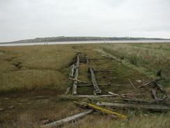
Take this road and cross over another roundabout to take Gas Road westwards. This road goes a short distance until it reaches the eastern bank of Milton creek, where it then turns to the right to head northwestwards. The road ends and a path continues on past the remains of an old brickworks until the channel of the Swale becomes visible.
Here the path turns from a northerly to an easterly heading, passing some flooded quarry workings in the process. It continues along the flood banking for a couple of miles until Conyer Creek is reached.
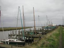
At Conyer Creek the path turns to the right to head southwards along the western bank of the creek. As it approaches the little village of Conyer at the southern end of the creek boats become visible and eventually a marina is reached. The path ends at a road beside the marina, and this heads eastwards along the southern edge of the creek to another road. Turn left up this road to head north up the eastern bank of the creek.
Shortly after the road passes a pub it turns to the left, but the Saxon Shore Way continues straight on along a muddy track. This winds around slightly but eventually it meets the Swale once more, immediately to the south of Fowley Island.
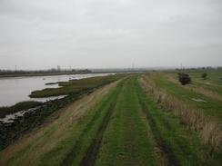
From here the path continues eastwards along the flood banking for over five kilometres, with some nice views being available to the right over Teynham Level and to the left over the Swale to the Isle of Sheppey. Eventually the path meets a road at a car park for the Oare Marsh Nature Reserve. The path continues on for another couple of hundred metres until Oare creek is reached. It then turns right to head south along the western bank of the creek. It passes under some power lines and about a mile further on it ends at a road.
Turn left and cross over a small causeway that carries the road over the southern edge of the creek. On the other side of the creek turn left, again following the Saxon Shore Way, and follow it as it heads northeastwards along the eastern bank of the creek along a track. When the track ends continue on along a path until you reach the Shipwrights Arms pub, which is situated at the point where Oare and Faversham Creeks meet. Follow the path as it follows the riverbank as it joins Faversham Creek and heads eastwards above Ham Marshes.
The riverbank then turns to head southeastwards and then southwestwards, heading back into Faversham. On the outskirts of Faversham the path heads off to the right inland to skirt some buildings, and then follows roads southwestwards through the town. Eventually it manages to cross Faversham Creek to the left and meets the B2041 main road. Turn left down the B2041 and follow it as it winds around past Faversham Church before heading southwards. Follow the road as it curves to the right and Faversham Station is about a hundred yards ahead on the right.
Distances
| From | To | Distance (m) | Ascent (ft) | Descent (ft) |
|---|---|---|---|---|
| Sittingboard Station | Conyer | 6.3 | 89 | 128 |
| Conyer | Faversham Station | 10.0 | 164 | 118 |
This makes a total distance of 16.3 miles, with 253 feet of ascent and 246 feet of descent.
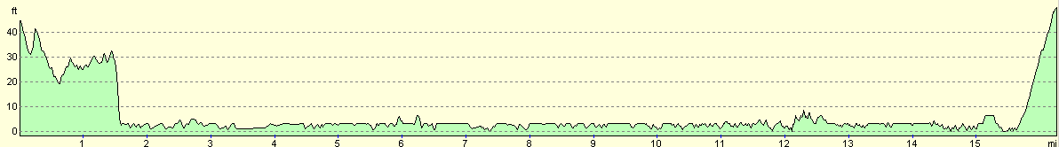
For more information on profiles, ascents and descents, see this page
Accommodation
We parked on he roadside in Faversham as there were no suitable campsites open in the immediate vicinity.
Disclaimer
Please note that I take no responsibility for anything that may happen when following these directions. If you intend to follow this route, then please use the relevant maps and check the route out before you go out. As always when walking, use common sense and you should be fine.
If you find any information on any of these routes that is inaccurate, or you wish to add anything, then please email me.
All images on this site are © of the author. Any reproduction, retransmissions, or republication of all or part of any document found on this site is expressly prohibited, unless the author has explicitly granted its prior written consent to so reproduce, retransmit, or republish the material. All other rights reserved.
Although this site includes links providing convenient direct access to other Internet sites, I do not endorse, approve, certify or make warranties or representations as to the accuracy of the information on these sites.
And finally, enjoy your walking!
This walk was mentioned in the following routes:
| My walk around the coastline of Britain |
Nearby walks
| # | Title | Walk length (miles) |
|---|---|---|
| 179 | Sittingbourne to Faversham | 13.9 |
| 288 | Lower Twydall to Sittingbourne | 18.8 |
| 290 | Faversham to Reculver | 17.8 |
|
|

|