Walk #179: Sittingbourne to Faversham
 |
 |
|
General Data
| Date Walked | 27/01/2002 |
| County | Kent |
| Start Location | Sittingbourne Station |
| End Location | Faversham Station |
| Start time | 09.10 |
| End time | 14.17 |
| Distance | 13.9 miles |
| Description | This was a nice walk, following the Saxon Shore Way as it follows the southern side of the channel carrying the Swale as it separates the Isle of Sheppey from the mainland. This was by no means a classic walk, but it was enjoyable nonetheless. |
| Pack | I carried my 30-litre rucksack with coat, extra top and water bottle inside it. This was considerably lighter than my normal pack. |
| Condition | I feel okay after this walk, but I am a little more fatigued than I would normally be after a walk of this length. I put this down to the fact that I did not have a stop in the middle of the walk as everywhere was so muddy and there were no obvious place where I could sit down for a rest. My shoulders, legs and feet are all fine with no new blisters having been formed, but I have a little ache in my lower back. The underside of my right foot was aching a little towards the end of the walk, which I discovered at the end was due to the fact that my outer sock had bunched up slightly as I had not put it on properly. |
| Weather | Today's weather was far better then the heavy rain that the forecast had promised. I did not glimpse the sun all day, but it was fairly mild so I did not feel too cold The wind was fairly gusty, but at no stage was it strong enough to chill me. There was a little spitting rain for a long period before I noticed that it was starting to get a little heavier, so I stopped to put my coat on. This seemed to be a single for it to stop raining, and I saw no more drizzle or rain for the rest of the journey. |
| OS map | Landranger number 178 (Thames Estuary, Rochester & Southend-on-Sea) |
 |
 |
|
Map of the walk
Maps courtesy of Google Maps. Route for indicative purposes only, and may have been plotted after the walk. Please let me have comments on what you think of this new format. For a detailed table of timings for this walk, please see the table file.
 |
 |
|
Notes
The weather forecast for today was very bad, with lots of rain forecast. I had been intending to do a 22-mile walk from Boston down to Spalding the previous day, but I decided doing such a long walk in wet weather was not very enjoyable. Because I am trying to get one walk done every weekend until the end of February, and because the weather forecast was for inclement weather I decided to do this (relatively) short and flat walk.
The start of this walk was along roads through Sittingbourne, and then past a football ground. This was a fairly uninspiring start, and it did not bode well for the rest of the walk. The area to the east of the Milton Creek is shown on the map as being a green area, but new developments and industrial units were springing up and the roads connecting them were not visible on the map. And this meant that I went slightly awry. I could see that the new roads headed in the direction that I wanted to be heading (northwards), so I followed them. Unfortunately the new roads ended at an old brick works, and I could not get from there to the path which ran along the eastern side of Milton Creek. I therefore had to go back a couple of hundred yards and find the proper path to the flood banking.
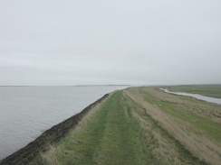
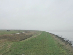
The Swale was the main feature of today's walk. This channel separates the mainland from the Isle of Sheppey, and at the start of the walk the tide was very high, making the channel a very wide expanse of water. Indeed in places it was only about a foot from the top of the flood banking, so I assume that it doe not normally get any higher than that.
The walk up Milton Creek to the Swale was also uninspiring, and was dominated by a large paper mill on the other bank that was adjacent to a tip. This was rather unscenic, and I hope that the rest of the walk would not be so dull.
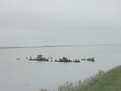
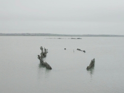
Fortunately things soon picked up once I started walking east along the floodbanks along the Swale. I came to an old boat hulk in the mud beside the floodbank, with what looked like another further out. A man passed by and I chatted to him for a while. It turned out that he worked at the paper mill that I had seen earlier and he told me that the two hulks were the remains of two second world war minesweepers, which had hulls built of wood so they would not attract magnetic mines. Unfortunately I have not been able to find out any more about these boats, information about minesweepers on the Internet being very sparse.
Just before Oare Creek is reached there is a car park and a building beside a slipway. The building and car park are part of a visitor's center for the Oare Marsh nature reserve. A track leads from the car park over the floodbank and down into the channel. From the map I could see that this track appears to come up at the Harty Ferry Inn on the Isle of Sheppey on the other side of the channel. This is the site of an old cable-drawn ferry which dates from 1657 and connected both sides of the channel.
I found it slightly difficult finding my way through Faversham, and I found it hard to locate the station (some signposts were pointing in the wrong direction). Unfortunately when I did get to the station I saw a train going back to Sittingbourne just leaving, and so I had an hour's wait until the next one. Instead of waiting around on the station I decided to explore the local area a bit, and I found my way into a nearby pub where I had a pint of coke whilst I waited.
Having completed this walk I now have a gap between Rochester and Sittingbourne that needs to be completed. If I have a spare weekend then I will do the next two stages eastwards (from Faversham to Herne Bay and Herne Bay to Margate) in a weekend, and leave the Rochester to Sittingbourne section for a spare Sunday.
Directions
This walk starts off at Sittingbourne Station. Leave the station and join the A2 road immediately in front of the station. Turn left and walk eastwards along the A2 for a short distance as it descends down a slight slope. Take the first road to the left, the B2006, which passes under the railway and ends at a roundabout on the other side. At the roundabout turn right and head east along Eurolink Way which parallels the railway line. When this road ends at a T-junction turn left to head north along Castle Road which leads into an industrial estate.
Continue on up this road and take the fourth road to the right, Dolphin Way, which is clearly signposted as being part of the 'Saxon Shore Way'. This road soon ends at a T-junction with Church Road, which the route follows to the left, heading northeastwards. This road passes a football stadium, and immediately beyond this Stadium Way leads off to the left.
Take this road and cross over another roundabout to take Gas Road westwards. This road goes a short distance until it reaches the eastern bank of Milton creek, where it then turns to the right to head northwestwards. The road ends and a path continues on past the remains of an old brickworks until the channel of the Swale becomes visible.
Here the path turns from a northerly to an easterly heading, passing some flooded quarry workings in the process. It continues along the flood banking for a couple of miles until Conyer Creek is reached.
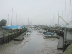
At Conyer Creek the path turns to the right to head southwards along the western bank of the creek. As it approaches the little village of Conyer at the southern end of the creek boats become visible and eventually a marina is reached. The path ends at a road beside the marina, and this heads eastwards along the southern edge of the creek to another road. Turn left up this road to head north up the eastern bank of the creek.
Shortly after the road passes a pub it turns to the left, but the Saxon Shore Way continues straight on along a muddy track. This winds around slightly but eventually it meets the Swale once more, immediately to the south of Fowley Island.
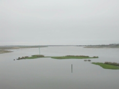
From here the path continues eastwards along the flood banking for over five kilometres, with some nice views being available to the right over Teynham Level and to the left over the Swale to the Isle of Sheppey. Eventually the path meets a road at a car park for the Oare Marsh Nature Reserve. The path continues on for another couple of hundred metres until Oare creek is reached. It then turns right to head south along the western bank of the creek. It passes under some power lines and about a mile further on it ends at a road.
Turn left and cross over a small causeway that carries the road over the southern edge of the creek. The road progresses to the southeast, becoming Oare Road as it passes an old windmill which is now sadly devoid of its sails. Oare Road ends at a junction with Priory Row, which can be followed southwards towards a church and some shops. Davington Hill Road goes off to the right, leading downhill past the church and ending beside a pond on Dark Hill Road.
Turn left and head southeastwards along Dark Hill Road. At a junction take West Street which ends at the B2040 South Road. From here take roads that head east to meet the B2041 Newton Road. Turn right to head south down the B2041 until it bends sharply to the right. Follow the road around the bend and Faversham Station is about a hundred yards ahead on the right.
Distances
| From | To | Distance (m) | Ascent (ft) | Descent (ft) |
|---|---|---|---|---|
| Sittingbourne Station | Conyer | 6.5 | 95 | 131 |
| Conyer | Faversham Station | 7.4 | 157 | 115 |
This makes a total distance of 13.9 miles, with 252 feet of ascent and 246 feet of descent.
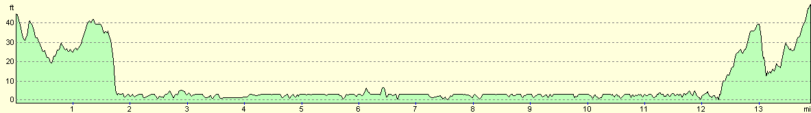
For more information on profiles, ascents and descents, see this page
Transport
There are regular train services running between Faversham and Sittingbourne. These trains run approximately hourly on Sundays and more regularly during the week. Sittingbourne station has free car parking on Sundays with plenty of space being available. There is an intermediate station at Teynham, but my train did not stop there and I do not know if it is open on Sundays.
Disclaimer
Please note that I take no responsibility for anything that may happen when following these directions. If you intend to follow this route, then please use the relevant maps and check the route out before you go out. As always when walking, use common sense and you should be fine.
If you find any information on any of these routes that is inaccurate, or you wish to add anything, then please email me.
All images on this site are © of the author. Any reproduction, retransmissions, or republication of all or part of any document found on this site is expressly prohibited, unless the author has explicitly granted its prior written consent to so reproduce, retransmit, or republish the material. All other rights reserved.
Although this site includes links providing convenient direct access to other Internet sites, I do not endorse, approve, certify or make warranties or representations as to the accuracy of the information on these sites.
And finally, enjoy your walking!
Nearby walks
| # | Title | Walk length (miles) |
|---|---|---|
| 288 | Lower Twydall to Sittingbourne | 18.8 |
| 289 | Sittingbourne to Faversham | 16.3 |
| 290 | Faversham to Reculver | 17.8 |
|
|

|