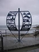
Walk #314: South Haven Point to Worth Matravers
 |
 |
|
General Data
| Date Walked | 02/01/2003 |
| County | Dorset |
| Start Location | South Haven Point |
| End Location | Worth Matravers |
| Start time | 08.55 |
| End time | 16.30 |
| Distance | 16.7 miles |
| Description | This was a long and difficult walk in some very muddy and slippy conditions, but it was well worth it for the execlent views that were available. |
| Pack | Today I carried my 30-litre Karrimor HotRock rucksack, which was filled with my packed lunch, waterproof leggings, water bottle and a couple of spare shirts, together with the usual assortment of odds and ends. |
| Condition | On the descent from the church at St Aldhelm's Head my legs ran out of energy and started to feel rubbery. This was compounded when I had to ascend steeply up the other side of the valley along a very muddy track. Towards the end of the walk I was also feeling nauseous as I had drunk lots of water and did not have enough food in my stomach. On top of all this I have a streaming cold and a stuffy head, so generally I did not feel very good all day. |
| Weather | There was torrential rain all night, and this continued through the long drive to the start of the walk from the campsite. Fortunately this stopped by the time I started the walk, and I only had to suffer a few drizzle showers during this morning. As the day went on the sky became clearer until eventually it was a nice, sunny day. Towards the end of the day the wind became stronger, until progress along the cliff tops was difficult at the other end of the walk. Indeed force ten gales are forecast for tonight, so we have tried to park the van in a spot sheltered from the wind. |
| OS map | Landranger number 195 (Bournemouth & Purbeck, Wimborne Minster & Ringwood) |
 |
 |
|
 |
 |
|
Map of the walk
Maps courtesy of Google Maps. Route for indicative purposes only, and may have been plotted after the walk. Please let me have comments on what you think of this new format. For a detailed table of timings for this walk, please see the table file.
 |
 |
|
 |
 |
|
Notes
For the last couple of weeks it has been my aim to walk continuously for over one hundred days. As of two days ago I was just over a week away from that target, and then yesterday I took my first day off on the entire trip. My reasons for this are simple to explain; I had some great company as my brother and sister in law were visiting, and the weather was awful, with torrential rain for the majority of the day. Either one of these I could have coped with, but having them visiting made me really no want to go out into the bad weather. We got up late, had a cooked breakfast, watched a DVD and then generally chatted and did nothing until at two in the afternoon Oliver and Sam had to go to make the long journey back to Derbyshire. It really was lovely to see them, and I miss them already.
After having taken a day off yesterday, the first in over ninety days of walking, I find myself wondering if I can do a walk tomorrow. For the first time in the walk, real doubt is in my mind about whether I can complete the walk. Taking a day off, particularly with such wonderful company, has helped me recharge my spirits, but already the concept of getting up and walking is alien in a way that it has not been for three months. It is a stupid and irrational way to feel, but I cannot help it. I will just have to get up in the morning and plod on, get some miles under my belt and build myself up again. I have always said that I expected this walk to be harder mentally than physically, and this is a classic example; the doubts do not come from any aches or pains in my body (which has been remarkably good during the walk), but from my mind. Doubt is creeping in, and all because I took a day off. I tried to explain this to Sam, but although she tries she cannot possibly understand, simply because I cannot adequately put into words how I am feeling mentally. For an outside observer taking one day off after ninety-two would mean nothing; for me it is like the walk has come to a premature end. I knew that I would have to mentally start again today, which is something that I was not looking forward to.
I put the afternoon to good use, and did some work on the scripts that run the website, including a project that I am fairly excited about but do not want to talk about yet. It feels really strange spending a few hours coding, as I have not done that for such a long time. Some of the work I did was to get the GenWalk script - which generates my itinerary - to cope with the fact that I too a day off, which it now does. Sometimes I feel like the only reason that I did not take a day off for those three months was avoiding doing that little amount of work!
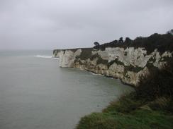
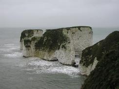
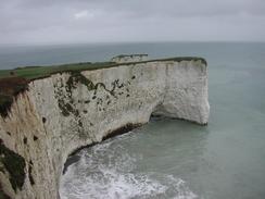
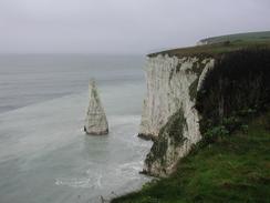
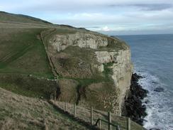
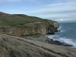
The main thing about today's walk was the mud, which was thick and cloying for much of the walk. The long section westwards from Durlston Head was particularly bad, and the path had long sections of mud along it that made walking much harder and tiring than should have been the case. In particular there were two downhill sections that were exceedingly slippy, and on one of them where a fence did not hem in the path I gave the path a wide berth and walked on the grass. Also in evidence was the main reason for the mud, the heavy rainfall that we have had over the last week. Many streams were overflowing and there were streams of water running down grassy areas, even though the rain stopped hours before.
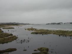
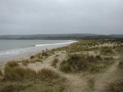
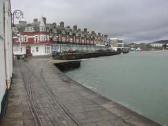
Annoyingly the tide was very high in the morning, and this meant that instead of being able to walk along the beach around the attractive Shell and Studland Bays I had to walk through the dunes behind them. These beaches are meant to be very attractive, but I could not really see any of them, as the tide was so high. To add insult to injury, when I was walking along the seafront promenade in Swanage a large wave broke aver the seawell and soaked me, which has made me hair feel very wiry ever since. A few minutes after the wave got me I saw a couple walking towards me, who commented on my slightly bedraggled state and so I warned them to beware of low-flying waves.
Swanage is a lovely little town, and I wish that I had had more time to look around it. I met Sam at the seafront before visiting a chemist to get something for my cold and going to see the very attractive town hall. I did have time to have a look around the Swanage Station of the Swanage Railway, which runs from the town as far as Corfe Castle. Ths was a shame as I would not have minded seeing what stock they had at the station.
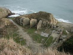
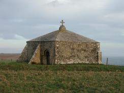
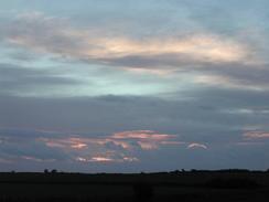
As I looked back over the coast late in the afternoon I could see The Isle of Wight shimmering in the distance to the east, providing memories of recent walks. Once I had rounded St Aldhelm's Head I could see the Isle of Portland in the distance to the west as the sky started to redden as the sun descended towards the horizon.
I could potentially have a problem tomorrow - once I get to Kimmeridge I have to cross the Lulworth army ranges, and if they are not open I have to make a diversion back nearly as far as Wareham! I cannot get mobile phone reception here, so I cannot phone the number up to see if the ranges are open as it is still school holiday. I shall have to reach near Kimmeridge to find out if this will be necessary.
 |
 |
|
 |
Directions
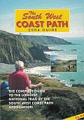
| During this walk I followed the South West Coast Path, the route of which is detailed in the Ordnance Survey National Trail Guide 11, Exmouth to Poole (ISBN 1-854109-88-X). Unfortunately the route description is written in reverse to the direction that I am walking, but the 1:25,000 maps in the book are clear and the signs on the ground are very good. Also to be recommended is the South West Coast Path Association guidebook (ISBN 0-907055-04-4), which has less concise directions and no maps but does include accommodation details and grades each section of the walk according to difficulty. They also publish reverse directions, which are suitable for walking in the direction that I walked the route. They have a website at www.swcp.org.uk, which is well worth a visit. | 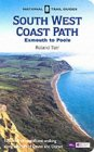
|
| 
| |
| |
| |
The only slight aside to this was the very end of the walk, when I walked inland eastwards from West Cliff to the church at Worth Matravers along a distinct and easy to follow (but very muddy) track.
Distances
| From | To | Distance (m) | Ascent (ft) | Descent (ft) |
|---|---|---|---|---|
| South Haven Point | Swanage | 7.4 | 669 | 669 |
| Swanage | West Cliff | 8.2 | 1804 | 1411 |
| West Cliff | Worth Matravers | 1.1 | 108 | 75 |
This makes a total distance of 16.7 miles, with 2581 feet of ascent and 2155 feet of descent.
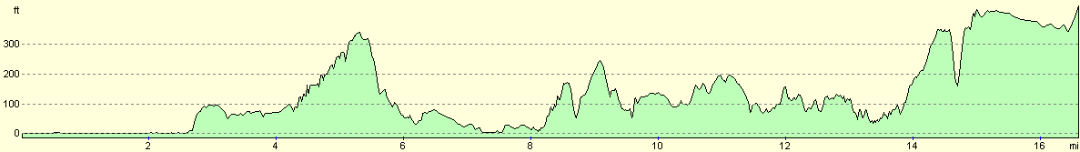
For more information on profiles, ascents and descents, see this page
Accommodation
We spent the night parked in the car park in Worth Matravers, beside the toilets so that we could use their facilities. The car park had a sign stating no caravans or overnight parking, but we ignored this advice as it was the only place in the village (which mainly comprises of narrow lanes) where we could find to park.
Disclaimer
Please note that I take no responsibility for anything that may happen when following these directions. If you intend to follow this route, then please use the relevant maps and check the route out before you go out. As always when walking, use common sense and you should be fine.
If you find any information on any of these routes that is inaccurate, or you wish to add anything, then please email me.
All images on this site are © of the author. Any reproduction, retransmissions, or republication of all or part of any document found on this site is expressly prohibited, unless the author has explicitly granted its prior written consent to so reproduce, retransmit, or republish the material. All other rights reserved.
Although this site includes links providing convenient direct access to other Internet sites, I do not endorse, approve, certify or make warranties or representations as to the accuracy of the information on these sites.
And finally, enjoy your walking!
This walk was mentioned in the following routes:
| My walk around the coastline of Britain |
| South West Coast Path |
Nearby walks
| # | Title | Walk length (miles) |
|---|---|---|
| 312 | Southbourne to Hamworthy Station | 15.3 |
| 313 | Hamworthy Station to South Haven Point | 18.0 |
| 315 | Worth Matravers to Lulworth Cove | 12.7 |
|
|

|