Walk #354: Wadebridge to Port Isaac
 |
 |
|
General Data
| Date Walked | 12/02/2003 |
| County | Cornwall |
| Start Location | Wadebridge |
| End Location | Port Isaac |
| Start time | 07.54 |
| End time | 15.23 |
| Distance | 18.8 miles |
| Description | One I had reached Rock and the start of the next section of the South West Coast Path this was a highly enjoyable and scenic walk, and well worth doing. The initial stretch, however, was far from nice as it involved walking along some fairly busy roads. |
| Pack | Today I carried my 30-litre Karrimor HotRock rucksack, which was filled with my packed lunch, waterproof leggings, water bottle and a couple of spare shirts, together with the usual assortment of odds and ends. |
| Condition | I feel absolutely fine after this walk, despite the last stretch being quite strenuous. For the first time in a few days I did not have any aching from my left ankle, of which I am thankful. |
| Weather | Today was another nice, dry and sunny day, and this made for some ideal walking weather. There was absolutely no sign of any rain, and it was quite warm (indeed, according to the weather forecast this area was the sunniest and warmest section of the whole country today). |
| OS map | Landranger number 200 (Newquay & Bodmin, Camelford & St Austell) |
 |
 |
|
 |
 |
|
Map of the walk
Maps courtesy of Google Maps. Route for indicative purposes only, and may have been plotted after the walk. Please let me have comments on what you think of this new format. For a detailed table of timings for this walk, please see the table file.
 |
Notes
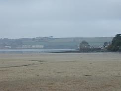
I thoroughly enjoyed this walk, and it was nice that I managed to get the first six miles completed fairly quickly. This meant that I could take my time over the rest of the walk, and this I gladly did. Having said this, the initial section of path, the six-mile stretch between Wadebridge and Rock, was a long and boring slog. Two miles of this was along the B3314 road and this was a far from pleasant experience, as the road was quite busy (it did not help that I was walking along it in the morning rush hour), and it was quite twisty with some fairly blind bends. It was a relief when I finished the stretch along the B3114 and got onto quieter local roads. There was little to commend this stretch of the walk, except perhaps for a lovely view I got on a few occasions over the valley of the River Camel, with a layer of fog above it - a beautiful sight.
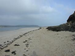
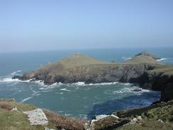
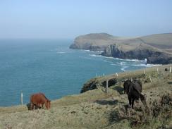
I had a little break on the path overlooking The Rumps, which is quite a spectacular headland. An ex-colleague of mine has some happy memories of this headland, so I tried to phone him but unfortunately he was not in. The view over the headland was very nice, and so it seemed like an ideal place to stop, and I looked at the banks that were part of an Iron Age Fort that is on the headland. I can well imagine why there was a fort there - it would be exceedingly had to attack the headland from the cliffs, and it would be easy to defend the narrow neck of the headland from land attack.
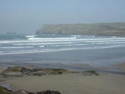
The section of path between Portquin and Port Isaac, although only a little over three miles long, is a very strenuous little stretch of path and it seemed like there were few places where I was not either ascending or descending. I had walked this stretch before and I had forgotten exactly how strenuous it was, but my legs soon reminded me well enough. The path is fenced off (although I found it quite strange that the fence was on the landward side and not the seaward side of the path), and I could see the fence climb up and down the side of the cliff in a manner that seemed impossible to walk - it is quite an impressive sight, although slightly daunting when you realise that you have to walk along it.
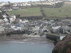
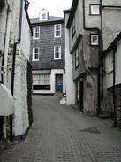
Port Isaac is an absolutely superb little village, and one that I remember fondly from my last trip through the area. Sam met me on the hill above the village where she had been watching a hunt go through, and we walked down the hill together to the very picturesque little harbour. The streets in the village are all very tiny and tight, and there is a famous one known as 'Squeeze-e-belly' alley - a very apt description. I had run out of water a little while before, and so I suggested that we find a pub in the village. We did this, and we ended up chatting to some of the locals. Four pints of HSD and three hours later we emerged from the pub (having got a few donations and free drinks) and walked up the hill. At least Sam walked, and I did a motion that could probably me more accurately described as a wobble! On the way there was a fish and chip shop, so we decided to treat ourselves and save Sam from having to cook. This all made for a highly enjoyable afternoon, although drinking alcohol after being slightly dehydrated is not the best idea in the world.
Tomorrow morning I have a very strenuous walk from Port Isaac to Tintagel to do, and although this walk will be hard I am quite looking forward to it as good views should be available. I am aiming to get as far as Boscastle tomorrow, but I am hoping that I may be able to walk a little further, but this would depend on how hard I find the initial stretch to be.
Directions
| During this walk I followed the South West Coast Path, the route of which is detailed in the Ordnance Survey National Trail Guide 8, Minehead to Padstow (ISBN 1-85410-774-7). Unfortunately the route description is written in reverse to the direction that I am walking, but the 1:25,000 maps in the book are clear and the signs on the ground are very good. Also to be recommended is the South West Coast Path Association guidebook (ISBN 0-907055-04-4), which has less concise directions and no maps, but includes accommodation details and grades each section of the walk according to difficulty. They also publish reverse directions, which are suitable for walking in the direction that I walked the route. They have a website at www.swcp.org.uk, which is well worth a visit. | 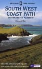
|
| 
| |
| |
| |
There are two distinct parts to this walk, and the first of these leads from the Old Bridge in Wadebridge to the South West Coast Path at Rock. Cross over onto the eastern side of the Old Bridge and follow the road around to the left and then the right, as it heads uphill to the northeast until it ends at a roundabout with the B3314 road. Turn left at the roundabout to head past a school along the B3314 road for a couple of miles, crossing the River Amble before reaching Gutt Bridge. After the bridge the road turns to the left to head uphill, and near the top of the hill take a road that leads off to the left. This road passes the farm at Tregenna and Trevelver as it slowly curves to head in a more northwesterly direction. At a road junction turn to the left and follow another road that heads back towards the river, passing Cant Farm and Cant Hill before curving to descend down towards the village of Rock. As the road approaches Porthilly Cove turn to the left down a footpath that leads for a short distance to the cove, and when the beach is met turn to the right down another footpath that leads up some steps and along a track to end at a road. At the road turn to the left and walk westwards to the Rock Ferry, where the ferry from Padstow lands.
Distances
| From | To | Distance (m) | Ascent (ft) | Descent (ft) |
|---|---|---|---|---|
| Wadrbridge | Rock | 6.9 | 650 | 640 |
| Rock | Port Isaac | 11.9 | 2598 | 2585 |
This makes a total distance of 18.8 miles, with 3248 feet of ascent and 3225 feet of descent.
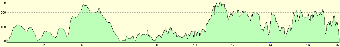
For more information on profiles, ascents and descents, see this page
Accommodation
We parked the van in the upper car park in Port Isaac which was a short distance from the centre of the village and is right on the South West Coast Path. Yet again there was a sign stating no overnight sleeping, and yet again we totally decided to ignore this. There were some great views from the car park over the cliffs to the east, and there was a lovely red sky the next morning as the sun rose from behind them.
Disclaimer
Please note that I take no responsibility for anything that may happen when following these directions. If you intend to follow this route, then please use the relevant maps and check the route out before you go out. As always when walking, use common sense and you should be fine.
If you find any information on any of these routes that is inaccurate, or you wish to add anything, then please email me.
All images on this site are © of the author. Any reproduction, retransmissions, or republication of all or part of any document found on this site is expressly prohibited, unless the author has explicitly granted its prior written consent to so reproduce, retransmit, or republish the material. All other rights reserved.
Although this site includes links providing convenient direct access to other Internet sites, I do not endorse, approve, certify or make warranties or representations as to the accuracy of the information on these sites.
And finally, enjoy your walking!
This walk was mentioned in the following routes:
| My walk around the coastline of Britain |
| South West Coast Path |
Nearby walks
| # | Title | Walk length (miles) |
|---|---|---|
| 81 | Newquay to Padstow | 14.5 |
| 82 | Padstow to Port Isaac | 11.1 |
| 83 | Port Isaac to Boscastle | 13.5 |
|
|

|