Walk #394: Llangranog to Aberath
 |
 |
|
General Data
| Date Walked | 25/03/2003 |
| County | Dyfed |
| Start Location | Llangranog |
| End Location | Aberath |
| Start time | 08.52 |
| End time | 16.45 |
| Distance | 16.9 miles |
| Description | This was quite a nice walk, mostly along cliff top footpaths but also including some roads. |
| Pack | Today I carried my 30-litre Karrimor HotRock rucksack, which was filled with my packed lunch, waterproof leggings, water bottle and a couple of spare shirts, together with the usual assortment of odds and ends. |
| Condition | I feel more or less okay after this walk, except for the fact that my left ankle is aching slightly, probably as a result of walking along the shingle at the end of the walk. Aside from this I am fine, and have had few other problems. My back, which I injured yesterday in a slight contretemps with a horse, thankfully gave me no trouble. |
| Weather | The weather was a combination of sunshine and cloud, with more of the former than the latter. There was no sign of any rain, and there was not much wind to cool me down either. Despite this it was a lovely day for a walk, and I can only hope that this spell of weather continues for as long as possible. |
| OS map | Landranger number 145 (Cardigan & Mynydd Preseli) and Landranger number 146 (Lampeter, Llandovery & surrounding area) |
 |
 |
|
 |
 |
|
Map of the walk
Maps courtesy of Google Maps. Route for indicative purposes only, and may have been plotted after the walk. Please let me have comments on what you think of this new format. For a detailed table of timings for this walk, please see the table file.
Notes
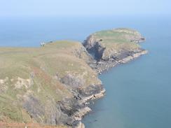
The day started off with a literal high with a lovely walk up and over a hill to a little headland near the island of Yns-Lochtyn. This is an absolutely lovely headland, and the National Trust for good reason owns it. It looked sublime in the morning sunshine, and I found it hard to tear myself away from it, but I had to press on.
I had a little surprise after this - on the map there is a complex of buildings called the Urdd Centre which the footpath passes through, and when I passed through it I discovered that it was a children's activity centre, complete with a dry ski slope and a chessboard painted on an area of tarmac, with huge pieces to be moved around. It looked as though the kids were enjoying themselves, I wish that I could have been to a place with a dry ski slope when I was a child, but having said that I think that I enjoyed my holidays well enough without them!
I read a little notice early on in this walk about Cardigan Island, which I passed yesterday. Apparently it used to have Puffins on it, but a shipwreck years ago allowed rats onto the steep-sided and fairly inaccessible island that proceeded to kill all the Puffins. The rats have now been eradicated, and to try to attract Puffins back to the island they have put concrete puffins on the cliffs!
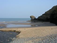
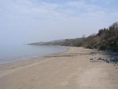
At Cwmtydu I paused to have a look at the beach and the nicely cosmetically restored lime kiln above the beach. Whilst I was there I passed a group of people, and one of them started chatting to me. It turns out that they were Jehovah's Witnesses, and they asked me if I wanted a copy of their magazine, a kind offer which I naturally refused.
I met Sam for lunch in New Quay, and I enjoyed looking around this attractive little town. The area around the harbour is very nice, although I did not get much of a chance to look around it. Dylan Thomas lived in the town in the 1940's, and there are numerous signs about hi, scattered around the town. I found the next little section of route quite difficult, as I had to try and get further around the coast. This involved initially walking along the main road out of the town before descending through a caravan park to the beach, which was a narrow strip due to the state of the tide.
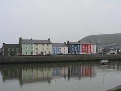
Aberaeron is a little gem, and I enjoyed my walk through it. The houses are all multi-coloured, and the reflection of these in the water of the harbour was fantastic. It really is a lovely little town, and I am slightly annoyed that I did not get a chance to have a better look around. The harbour area is nice, and everything is nice and tidy, something that has let down several nice towns that I have seen on this walk. The Reverend Alban Thomas Jones planned the harbour and street layout in the early nineteenth century.
I am very unsure about what is going to happen tomorrow. The map showed a footpath along the last part of today's walk, but I could find no trace of it and so I walked along the beach instead. Tomorrow there are some footpaths along the cliffs towards Aberystwyth, but John Merrill said that thsee were not obvious when he walked the route in 1977. I will try to find the paths, but if I cannot find them then I will be forced to walk along the A487(T) instead, which will not be massively enjoyable but may be simpler.
Directions
This road starts off at the car park beside the beach in Llangranog. Walk to the beach and turn right to find some steps that lead up the cliffs to the eastern side of the bay. These steps lead up to a footpath that heads north towards the little peninsular beside Ynys-Lochtyn. Before the path reaches there a track is joined; a few yards after this track is reached turn left and go down another footpath that allows access to the headland, which can be explored at your leisure. Return back up to the track by the same route or by using another footpath that heads eastwards and saves a few yards. Continue on along the track and then take a footpath that heads eastwards before heading inland to reach the Urdd Centre. Walk through the Urdd Centre on a road and continue along this road until it ends at a T-junction with the B4321 road. Turn left down this road and when it curves slightly to the right continue straight on up another, minor, road.
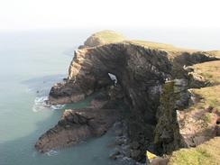
Follow this road as it heads through Ciliauhwny and Cilie before descending through a wooded area before crossing the Afon Ffynnon Ddewi and ending at a T-junction. Turn left at this junction and follow another road northwards to the car park beside the beach at Cwmtydu. Walk along he road behind the beach and then turn left to take a footpath that leads uphill to the northeast. At the top of the hill continue on along the footpath as it skirts the coast; some sections of it are not marked on the Ordnance Survey map but are very distinct on the ground; steps have even been created in places. Keep close to the coast and you will not be able to go much wrong. Follow the path northeastwards until it reaches New Quay Head, and then descend down to reach a road that leads to the harbour in New Quay.
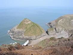
From the harbour follow the B4342 road southeastwards out of the town. When a large caravan park is reached head though this downhill and down onto the beach of the tide is out. The path from the park down the low cliffs was not very good; care should be taken. Once on the beach turn right and follow it past a little headland (again, care should be taken of the tide is high) and into Little Quay Bay. In Little Quay Bay take a track that leads up to a road by a car park, and when this road curves to the right head straight on down a short track into a farmyard. Just before the farm is reached turn left down a footpath that heads northeastwards paralleling the cliffs until it reaches a caravan park at Gilfach-yr-Halen. Go through the caravan park and join the public road; do not descend down this road to the beach, as there is not footpath leading eastwards up the cliffs. Instead turn right to follow a road that curves around to head northeastwards, and after about a hundred yards a footpath leads off to the left to reach the cliffs.
When this footpath reaches the cliffs turn right and follow the clifftop path northeastwards all the way into the town of Aberaeron. In the town walk around the harbour and then follow a footpath northeastwards for two miles into Aberath. Unfortunately this path soon disappears, and I had to walk along the shingle beach, which should not be attempted if the tide is high as it would be very dangerous. When Aberath is reached take the first track up off the beach, and this is where this walk ends.
Distances
| From | To | Distance (m) | Ascent (ft) | Descent (ft) |
|---|---|---|---|---|
| Llangranog | New Quay | 8.8 | 2001 | 2001 |
| New Quay | Aberaeron | 6.3 | 1296 | 1289 |
| Aberaeron | Aberath | 1.8 | 56 | 56 |
This makes a total distance of 16.9 miles, with 3353 feet of ascent and 3346 feet of descent.
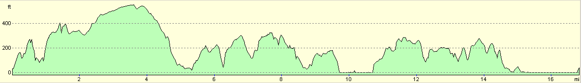
For more information on profiles, ascents and descents, see this page
Accommodation
We stayaed at the Brynarian Caravan Park, Cross Inn, Llanon, Ceredigion SY23 5NA. This site cost us six pounds for the night, and was quite reasonable for that price. There was a trampoline in the touring park, and I had to resist the urge to go bouncing around. The campsite can be contacted on (01974) 272231.
Disclaimer
Please note that I take no responsibility for anything that may happen when following these directions. If you intend to follow this route, then please use the relevant maps and check the route out before you go out. As always when walking, use common sense and you should be fine.
If you find any information on any of these routes that is inaccurate, or you wish to add anything, then please email me.
All images on this site are © of the author. Any reproduction, retransmissions, or republication of all or part of any document found on this site is expressly prohibited, unless the author has explicitly granted its prior written consent to so reproduce, retransmit, or republish the material. All other rights reserved.
Although this site includes links providing convenient direct access to other Internet sites, I do not endorse, approve, certify or make warranties or representations as to the accuracy of the information on these sites.
And finally, enjoy your walking!
This walk was mentioned in the following routes:
| My walk around the coastline of Britain |
Nearby walks
| # | Title | Walk length (miles) |
|---|---|---|
| 393 | Cardigan to Llangranog | 17.2 |
|
|

|