Walk #414: Penmaenmawr to Rhos-on-Sea
 |
 |
|
General Data
| Date Walked | 15/04/2003 |
| County | Conwy |
| Start Location | Penmaenmawr |
| End Location | Rhos-on-Sea |
| Start time | 09.00 |
| End time | 18.09 |
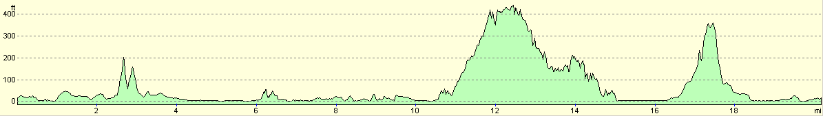
| Distance | 20.2 miles |
| Description | This was quite a strange walk, as much of it was alongside busy roads, but with some lovely views available along the coast as the traffic roared by. |
| Pack | Today I carried my 30-litre Karrimor HotRock rucksack, which was filled with my packed lunch, waterproof leggings, water bottle and a couple of spare shirts, together with the usual assortment of odds and ends. |
| Condition | I suffered over the last few miles, and investigation when I finished the walk showed that I have a big blister on the underside of my right foot. This was probably caused y sand getting into my shoe and rubbing in that spot, although I cannot be sure. I shall have to put a Compeed over the blister before tomorrow's walk. Aside from this I am fine; my legs could have walked much further but the underside of my feet prevented me from doing this. |
| Weather | This was another fine, sunny day, with scarcely a cloud to be seen in the sky. In the afternoon it got quite hot, and there was not much wind to cool me down. |
| OS map | Landranger number 115 (Snowdon & surrounding area) and Landranger number 116 (Denbigh & Colwyn Bay) |
 |
 |
|
 |
 |
|
Map of the walk
Maps courtesy of Google Maps. Route for indicative purposes only, and may have been plotted after the walk. Please let me have comments on what you think of this new format. For a detailed table of timings for this walk, please see the table file.
 |
Notes
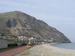
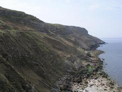
The first part of this walk eastwards from Peanmeanmawr was a fairly boring walk along the cycle track that runs alongside the A55. It was a good, firm surface to walk along, and there were some lovely views available out to sea, but the close proximity of the traffic was annoying. Amore inland route (for instance following the North Wales Path) would be much preferable, but of course would not be coastal. I was glad when I left the cycle track and diverted along the path around Conwy Morfa. This footpath was jammed between a golf course and the sand dunes, and whilst walking along I got sand in my trainers and I did not stop to empty them, a mistake I came to regret later on. I also tripped over a bramble that was across the track, and I got spiked in the palm of my left hand by some Marram grass.
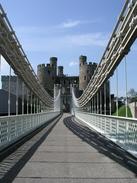
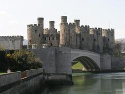
I met Sam near the smallest house in Britain in Conwy; a nineteenth century house on the riverfroont with a six foot frontage and a height of only ten feet two inches, and we walked into the town so that we could have a drink and a rest. After we left we had a quick look around the town - it is truly a superb place, and somewhere that I would not mind looking around again in more detail. The castle itself is superb - built by Edward I in 1283 it is extremely well preserved, as are the town walls that are still mostly complete. After I left Sam I walked down to cross Telford's original suspension bridge. The National Trust now owns this, and it fits in with the castle behind it perfectly. The towers of the bridge are stylistically identical to the castle, and the whole thing looks superb. The bridge costs one pound ten pence to cross, and so when I reached the tollbooth on the eastern side of the bridge I nipped in to pay. There is a little exhibition on the bridge and whilst I had a look around this a Japanese family came in. We started chatting, and they gave me a donation before taking me outside to photograph me; firstly with me facing the camera and secondly with my back to them, so they could photograph the details on the back of my rucksack! I then went back inside so that I could buy a copy of a book on all the crossing of the Conwy River, but the Japanese gentleman insisted that he buy it for me, which was very kind of him.
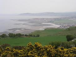
I read this book as I walked along the embankment that leads from the bridge to the shore, and then as I headed northwestwards along roads towards Llandudno. I had already decided that the highlight of the walk was to be the walk around Great Orme. This follows the Marine Drive, a four and a quarter mile road that was built between 1873 and 1878 for a total cost of ú14,000. The views from the road were lovely, and I enjoyed the walk around. It was slightly depressing that I ended up only a few hundred yards from where I started the walk around the hill, although the views made it worthwhile. I met Sam about a mile from the end of the drive, and we walked together to the end. In Llandudno I had to get some electronic equipment, so we went around a couple of shops before finding a pub where I could have a rest. I used the opportunity to take my trainers off in the pub, and I found that there was lots of sand in the bottom, and that my right foot had the start of a blister forming. I smeared the underside of that foot with Vaseline, and I hoped that this would stop it from developing further.
The walk along the seafront of Llandudno and on to Little Orme Head was fairly nice, and I soaked up the sun as I walked. There was nothing too spectacular about the section, and I read the book as I walked along. I reached Rhos-on-Sea in good time, and I diverted ever so slightly to have a look at the smallest chapel in Wales, a six foot by twelve foot stone building on the seafront in the town. It is an amazing little chapel, and it is hard to believe that it is a chapel - it is smaller than my dad's garden shed! Services are still held in the chapel every Friday at eight in the morning, and it makes me wonder how many people can fit inside it.
This evening we both wanted to have a drink, and so we went out to one of the local pubs for a drink. The pub was quite busy and so we asked if we could do a collection, and when they agreed I went back to Mervan to put on a Coastwalk T-shirt and get a collecting tin. The people in the pub were very kind, and when we left we went to another local pub and did the same there. We collected quite a tidy little sum this evening, and it may be worth doing the same thing in a few pubs in Prestatyn tomorrow.
Tomorrow's walk appears to be fairly straight forward; there is a cycle track running right alongside the coast as far as Prestatyn, and that will be what I walk along. Unfortunately this means another day of walking along a hard surface, and so I shall have to strap my feet up well to prevent the blister that I got today from spreading further. Hopefully this will also stop my feet from aching too much, as this proved highly annoying towards the end of today's walk.
Directions
This walk starts off at a car park at the western end of the promenade in Penmaenmawr. Leave the car park and head eastwards along the promenade through the town. When it ends climb up and join a cycle path that runs alongside the A55 road. Follow the cycle path as it heads eastwards for a few miles as it passes Penmaen-bach Point and goes on until there is a road junction.
Follow the slip road up and then turn left along a road, and when this curves to the right turn left along a track that heads westwards past Conwy Morfa. When a car park is reached turn right and follow a footpath behind the dunes that curves around until it reaches Conwy Marina.
Enter the car park near the marina and then head south along a road that crosses the A55 on a bridge near the entrance to the Conwy Tunnel. a short distance after this a path leads off to the left to rejoin the river bank; I went a slightly different way. The path soon reaches the outskirts of Conwy, where a road leads south to the road bridge over the River Conwy beneath the castle.
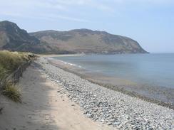
Cross the approach road and then take the Conwy suspension bridge over the river, and on the other side continue on eastwards along the embankment. Cross a bridge over the A55 and then turn left along the A546 until Degahwy Station is reached. At the station turn left down another road that ends at a beach. A footpath then head northwards behind the beach for a couple of mile to West Beach in Llandudno.
Head past the West Beach and then join the Marine Drive, which heads for four miles around Great Orme's Head before eventually reaching the pier in Llandudno. Continue on down into the town and then join the promenade and follow it eastwards through the town. When the promenade ends join the B5115 road and continue on along it past the southern flank of Little Ormes Head.
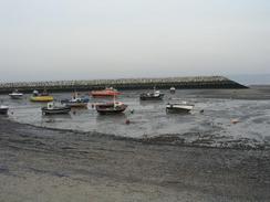
Just before a right-hand bend in the road a footpath lead off to the left to climb around the headland along an obvious and well-marked path before descending down to join a road. Head down this road southeastwards and then join a promenade when this starts, and follow it past the harbour of Rhos-on-Sea, where this walk ends.
Distances
| From | To | Distance (m) | Ascent (ft) | Descent (ft) |
|---|---|---|---|---|
| Penmaenmawr | Conwy | 6.7 | 584 | 591 |
| Conwy | Llandudno | 8.4 | 1526 | 1535 |
| Llandudno | Rhos-on-Sea | 5.1 | 531 | 515 |
This makes a total distance of 20.2 miles, with 2641 feet of ascent and 2641 feet of descent.
For more information on profiles, ascents and descents, see this page
Accommodation
We parked Mervan on a road just off the promenade in the centre of Rhos-on-Sea; the promenade has signs prohibiting motor homes fro parking overnight. We simply moved inland a few yards and parked near a convenient and nice pup, which proved to be perfectly quiet enough.
Disclaimer
Please note that I take no responsibility for anything that may happen when following these directions. If you intend to follow this route, then please use the relevant maps and check the route out before you go out. As always when walking, use common sense and you should be fine.
If you find any information on any of these routes that is inaccurate, or you wish to add anything, then please email me.
All images on this site are © of the author. Any reproduction, retransmissions, or republication of all or part of any document found on this site is expressly prohibited, unless the author has explicitly granted its prior written consent to so reproduce, retransmit, or republish the material. All other rights reserved.
Although this site includes links providing convenient direct access to other Internet sites, I do not endorse, approve, certify or make warranties or representations as to the accuracy of the information on these sites.
And finally, enjoy your walking!
This walk was mentioned in the following routes:
| My walk around the coastline of Britain |
Nearby walks
| # | Title | Walk length (miles) |
|---|---|---|
| 412 | Moelfre to Beaumaris | 18.1 |
| 413 | Beaumaris to Penmaenmawr | 18.1 |
|
|

|