Walk #26: Waterbeach to Dullingham
General Data
| Date Walked | 03/07/1999 |
| County | Cambridgeshire |
| Start Location | Waterbeach |
| End Location | Dullingham Station |
| Start time | 09.25 |
| End time | 13.10 |
| Distance | 10.7 miles |
| Description | The was a pleasant little walk heading eastwards from Waterbeach. |
| Pack | My pack was half full; I was not carrying a tent. |
| Condition | I feel slightly tired after this walk, but my legs are reasonable and my feet okay. I do not feel as though I have any blisters, which considering that the majority of the walk was on tracks and roads is not bad going. |
| Weather | Despite very heavy thunderstorms at 04.00 this morning, the walk was dry. It was overcast but very hot and sticky, with a light breeze and the sun occasionally making an appearance. |
| OS map | Landranger number 154 (Cambridge & Newmarket, Saffron Walden) |
Map of the walk
Maps courtesy of Google Maps. Route for indicative purposes only, and may have been plotted after the walk. Please let me have comments on what you think of this new format. For a detailed table of timings for this walk, please see the table file.
Notes
When I woke up this morning I could see that it was a good day for a walk, although I really could not be bothered travelling a long distance to do one. Instead of catching a train somewhere I decided to walk from my home in Waterbeach, and after consulting the map I decided that Dullingham, just inside the Cambridgeshire / Suffolk border, would be a good destination.As I looked at the map a route formed that involved much road walking in the latter stages; although this is not ideal scenically it would mean that I could walk very fast and not strain myself too much.
The initial stretch of the walk was along the River Cam from Bottisham Lock, a walk that I have done several times before. I soon turned away from the Cam, however, and followed Swaffham Bulbeck Lode as it headed, straight as an arrow, to the southeast towards Commercial End in Swaffham Bulbeck. These Lodes running off the Cam were the commercial life-blood of the area until the early 1900's; boats would bring goods down the Cam and up the Lodes into the centre of the villages. Nowadays, however, several of them (including this one) are silted up and only a couple are navigable by boats, and then pleasure boats, not the lighters that would ply their trade up and down the river. It is believed that Swaffham Bulbeck Lode is Roman in origin, although it was not believed to have been used much from the end of the Roman occupation until the 1700's, when the Commissioners of the Bedford Levels had to dredge it and strengthen the banks after several complaints.
The lode ends at the pretty hamlet of Commercial End, and Swaffham Bulbeck itself proved to only be a mile further on. Once in Swaffham Bulbeck I chose to follow the road that headed southeastwards, also carrying the Newamrket cycleway on the way towards the town. The surrounding Fenland is fairly flat, and there was not much of massive interest to see as I plodded my way along the road. A bridge took the road and me over the A14(T), and shortly afterwards I crosses the A1303 and continued on to the A1304. Here I decided not to walk on into Newmarket but to end the stroll at Dullingham Station, which was only a couple of miles away down another road - one of my feet had developed a hot-spot that I did not want to turn into a blister.
Dullingham Station is, like the village itself, a bit of a rural backwater, and there was not much to do or see in the area around the station whilst I waited for my train. The station is, however, famous for an incident that occurred in 1896 when the racehorse 'Persimmon', owned by Queen Victoria's son the Prince of Wales (later King Edward VII), nearly missed the Derby. He had been led down the nearby lanes to the station so that he could be loaded into a boxcar for the train journey down to Epsom, but try as they might they could not get him into the horsebox. It eventually took a dozen men to get him in but it was worth the effort - he went on to win the Derby by a neck.
Directions
From Waterbeach, walk to the River Cam at Bottisham Lock and cross over onto the eastern bank. Turn left at the gate and follow the river northwards until you pass Lode Farm to reach Swaffham Bulbeck Lode.
You can choose to either follow the northern or southern banks of the Lode eastwards. The northern bank has a track at its base, which can make the going easier if the top of the bank is overgrown. After about three miles you reach Abbey Lane at Cows Bridge. Turn left here, and follow the road around a bend. Just after a walled garden on the right (complete with many years worth of graffiti), turn right along Heath Road through Commercial End and follow the road until it ends at the B1102 in Swaffham Bulbeck.
Cross tge B1102 and continue straight on along a road. This curves to the right; take the first road off to the left, Swaffham Heath Road, and join the Newmarket Cycleway towards Dullingham. It heads southeastwards; cross over the A14 via a bridge and continue on. When the A1303 is reached cross over it and follow a road towards the A1304.
Turn right onto the A1304 for 100 yards and then cross over and turn left down a road eastwards towards Dullingham and the station is about a mile further on.
Distances
| From | To | Distance (m) | Ascent (ft) | Descent (ft) |
|---|---|---|---|---|
| My home in Waterbeach | Swaffham Bulbeck | 5.7 | 33 | 13 |
| Swaffham Bulbeck | Dullingham station | 5.0 | 318 | 102 |
This makes a total distance of 10.7 miles, with 351 feet of ascent and 115 feet of descent.
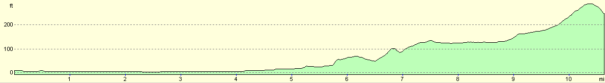
For more information on profiles, ascents and descents, see this page
Transport
There are regular train services between Dullingham and Cambridge stations; after this you can change trains to catch one north to Waterbeach.
Disclaimer
Please note that I take no responsibility for anything that may happen when following these directions. If you intend to follow this route, then please use the relevant maps and check the route out before you go out. As always when walking, use common sense and you should be fine.
If you find any information on any of these routes that is inaccurate, or you wish to add anything, then please email me.
All images on this site are © of the author. Any reproduction, retransmissions, or republication of all or part of any document found on this site is expressly prohibited, unless the author has explicitly granted its prior written consent to so reproduce, retransmit, or republish the material. All other rights reserved.
Although this site includes links providing convenient direct access to other Internet sites, I do not endorse, approve, certify or make warranties or representations as to the accuracy of the information on these sites.
And finally, enjoy your walking!
Nearby walks
| # | Title | Walk length (miles) |
|---|---|---|
| 11 | Stanton Moor | 2.9 |
| 12 | Darley Dale, Stanton Moor and Rowsley | 8.7 |
| 14 | Friden, Long Dale and Gratton Dale | 7.8 |
|
|

|