Walk #27: Waterbeach to Newmarket
General Data
| Date Walked | 17/07/1999 |
| County | Cambridgeshire, Suffolk |
| Start Location | Waterbeach |
| End Location | Newmarket |
| Start time | 07.50 |
| End time | 14.02 |
| Distance | 16.5 miles |
| Description | A nice walk to Newmarket, following the Devils Dyke. This was very similar to walk eight. |
| Pack | Today I carried the full kit that I expect to use on the Pennine Way. |
| Condition | I feel very tired after this walk. |
| Weather | Today's weather was very hot and sunny. |
| OS map | Landranger number 154 (Cambridge & Newmarket, Saffron Walden) |
Map of the walk
Maps courtesy of Google Maps. Route for indicative purposes only, and may have been plotted after the walk. Please let me have comments on what you think of this new format. For a detailed table of timings for this walk, please see the table file.
Notes
There is not long to go now until my planned attempt on the Pennine Way in August; with the lack of hills in Cambridgeshire I decided to get a long walk done with the full kit that I planned to take on that trip. It involved walking along the Devil's Dyke, which was failry overgrown. Iyt proved to be a very hot day; too hot for this length of walk. I fear that I still have a long way to go before I reach full fitness.
Directions
Leave Waterbeach by following the road to the river at Bottisham Lock. Cross over to the eastern bank of the river via the bridges at the lock and turn left to follow the river northwards. When you reach Swaffham Bulbeck Lode turn right and follow it on its northern bank. About halfway along the Lode at TL 539653 take a track to the left that passes Slades Farm, followed by a right to head southeastwards along a road. Shortly after the overhead powerlines take a left turn along a public byway called Black Droveway. This ends at a road, that can be followed all of the way into Reach.
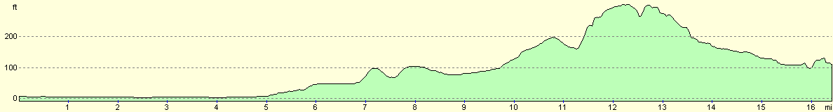
Devils Dyke starts at the eastern end of Reach village green. Climb up onto the banking and follow it for the next 7 miles, crossing the A14, Newmarket Racecourse and many minor roads in the process. In summer be prepared to be attacked my much overhanging vegetation, and in winter be prepared to have some muddy slopes to clamber up.
Near the end of the Devils Dyke in Wooditton at TL648588, turn left to follow a footpath eastwards across a field to join the Icknield Way at Dane Bottom. Turn left and follow the Icknield Way. Cross over a road by Court Barns Farm and continue to follow the footpath northwestwards. When you reach the B1061 turn right and follow it for 1.5 miles into Newmarket. When the road takes a sharp left turn right and follow the road to the next left turn (before the bridge over the railway) and follow this road to the station.
Distances
| From | To | Distance (m) | Ascent (ft) | Descent (ft) |
|---|---|---|---|---|
| My flat in Waterbeach | Reach | 5.8 | 36 | 16 |
| Reach | Dane Bottom | 7.1 | 423 | 161 |
| Dane Bottom | Newmarket Station | 3.6 | 72 | 253 |
This makes a total distance of 16.5 miles, with 531 feet of ascent and 430 feet of descent.
For more information on profiles, ascents and descents, see this page
Transport
There are regular train services between Newmarket and Cambridge; after this you need to take a train from Cambridge back to Waterbeach.
Disclaimer
Please note that I take no responsibility for anything that may happen when following these directions. If you intend to follow this route, then please use the relevant maps and check the route out before you go out. As always when walking, use common sense and you should be fine.
If you find any information on any of these routes that is inaccurate, or you wish to add anything, then please email me.
All images on this site are © of the author. Any reproduction, retransmissions, or republication of all or part of any document found on this site is expressly prohibited, unless the author has explicitly granted its prior written consent to so reproduce, retransmit, or republish the material. All other rights reserved.
Although this site includes links providing convenient direct access to other Internet sites, I do not endorse, approve, certify or make warranties or representations as to the accuracy of the information on these sites.
And finally, enjoy your walking!
This walk was mentioned in the following routes:
| A walk around East Anglia |
Nearby walks
| # | Title | Walk length (miles) |
|---|---|---|
| 13 | Edale and Kinder Scout | 11.0 |
| 14 | Friden, Long Dale and Gratton Dale | 7.8 |
| 17 | Alport circular | 11.8 |
|
|

|