Walk #25: Waterbeach to Cambridge via Quy
General Data
| Date Walked | 26/06/1999 |
| County | Cambridgeshire |
| Start Location | Waterbeach |
| End Location | Cambridge Station |
| Start time | 08.25 |
| End time | 12.25 |
| Distance | 11.0 miles |
| Description | This was a pleasant stroll from Cambridge to Lode, Quy, Teversham and then the Station. |
| Pack | My pack was half-full for this walk, and I did not carry a tent. |
| Condition | After not having done any walks for a month, my feet suffered more than they should have done. |
| Weather | Today as sunny, and one of the warmest days of the year so far. |
| OS map | Landranger number 154 (Cambridge & Newmarket, Saffron Walden) |
Map of the walk
Maps courtesy of Google Maps. Route for indicative purposes only, and may have been plotted after the walk. Please let me have comments on what you think of this new format. For a detailed table of timings for this walk, please see the table file.
Notes
This was a short but enjoyable stroll across the Fenland to the northeast of Cambridge. I met up with a couple of friends in Cambridge who were visiting for the day - it feels a little odd to walk into pubs carrying my heavy pack!
Directions
From Waterbeach, walk to the river at Bottisham Lock. Cross the river and turn left for a few hundred yard until you reach Bottisham Lode. Follow the lode eastwards until you reach a road, You can follow either the northern or southern banks along the lode, and there is a track at the base of the northern bank. Continue along the road that follows the lode. Eventually you will reach a bridge over the lode on the that was part of the old Cambridge to Mildenhall railway line,
Follow the course of the old railway line southwards along a concessionary footpath. When this footpath ends, take a left turn and follow another footpath along a track down to Station Road. Turn left and follow the road past Quy Hall and into the village of Stow cum Quy. When you reach the B1102, turn right and follow it southwestwards towards Cambridge. Just before the junction leading to the A14, take a right down the lane leading to the Quy Mill Hotel. Just before the hotel is reached the track parallels the A14; to the left there is a tunnel leading south under the A14 and onto the A1303.
Turn right along the A1303 for a hundred yards, then cross over and take a footpath leading southwards following a stream towards Teversham. When you reach a road, turn right along High Street and then left along Cherry Hinton Road. This meets Airport Way and continues southwards, skirting Cambridge Airport. Cross over a roundabout and take the right major road to the right, Coldhams Lane.
A third of a mile along Coldhams Lane there is a footpath leading to the left at TL485573. Take this path and follow it as it curves to the right and heads westwards to a bridge over a railway line. The footpath ends at Burnside, and a short distance on reaches the A1134 ring road. Cross this and continue straight on westwards along Mill Road for two thirds of a mile. Turn left along the first road on the left after crossing a railway bridge, Devonshire Road. Follow this road as it heads south; it swings to the right and then to the left before ending at Station Road. Turn left along Station Road to head eastwards for a few hundred yards before Cambridge railway station is reached.
Distances
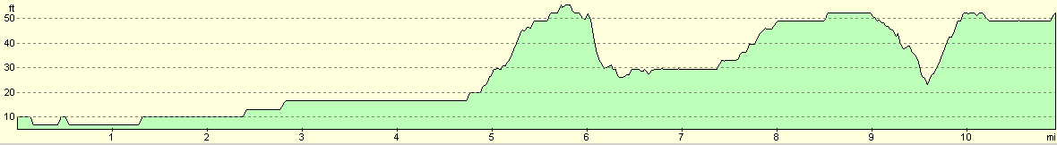
| From | To | Distance (m) | Ascent (ft) | Descent (ft) |
|---|---|---|---|---|
| My flat in Waterbeach | Tunnel under the A14 | 6.2 | 56 | 36 |
| Tunnel under the A14 | Cambridge station | 4.8 | 69 | 46 |
This makes a total distance of 11.0 miles, with 125 feet of ascent and 82 feet of descent.
For more information on profiles, ascents and descents, see this page
Transport
Regular railway services run between Cambridge and Waterbeach stations.
Disclaimer
Please note that I take no responsibility for anything that may happen when following these directions. If you intend to follow this route, then please use the relevant maps and check the route out before you go out. As always when walking, use common sense and you should be fine.
If you find any information on any of these routes that is inaccurate, or you wish to add anything, then please email me.
All images on this site are © of the author. Any reproduction, retransmissions, or republication of all or part of any document found on this site is expressly prohibited, unless the author has explicitly granted its prior written consent to so reproduce, retransmit, or republish the material. All other rights reserved.
Although this site includes links providing convenient direct access to other Internet sites, I do not endorse, approve, certify or make warranties or representations as to the accuracy of the information on these sites.
And finally, enjoy your walking!
Nearby walks
| # | Title | Walk length (miles) |
|---|---|---|
| 2 | Waterbeach to Newmarket Road, Cambridge | 5.4 |
| 5 | A short walk around Waterbeach to Car Dyke | 3.0 |
| 6 | Waterbeach to Newmarket Road, Cambridge | 5.4 |
|
|

|