Walk #472: Lochgilphead to Tarbert
 |
 |
|
General Data
| Date Walked | 14/06/2003 |
| County | Strathclyde |
| Start Location | Lochgilphead |
| End Location | Tarbert (Kintyre) |
| Start time | 09.03 |
| End time | 13.56 |
| Distance | 13.9 miles |
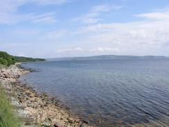
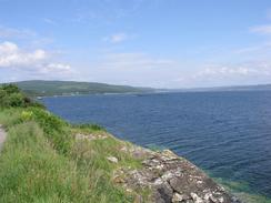
| Description | This was a straightforward plod southwards along the A83(T), with some lovely views available over Loch Fyne. |
| Pack | Today I carried my 70-litre Craghoppers rucksack with full camping equipment, including four days food and my boots. |
| Condition | The worst problem today was with my shoulders, which really complained with about the extra weight that I was forcing them to carry. I found the fourteen miles to be quite hard, although for the first time in a few days my feet did not ache too much. |
| Weather | Today was really sunny, with only occasional cloudy periods. As a result of this it got quite warm, and there was not much wind to help cool me down. All in all it was a lovely day for walking. |
| OS map | Landranger number 55 (Lochgilphead & Loch Awe) and Landranger number 62 (North Kintyre & Tarbert) |
 |
 |
|
 |
 |
|
Map of the walk
Maps courtesy of Google Maps. Route for indicative purposes only, and may have been plotted after the walk. Please let me have comments on what you think of this new format. For a detailed table of timings for this walk, please see the table file.
 |
 |
|
Notes
The first thing to mention about this walk was that it was the shortest day's walk that I have walked for some weeks. The main reason behind this was that the next stretch of walk was nine miles over the hills to Skipness, and I did not want to do this after the fourteen mile walk this morning. This will leave me with the nine miles to Skipness, plus another two further on to Claonaig, to catch the ferry over to Arran tomorrow. Once I get there I can walk another few miles to start the walk around the island.
Last night Sam and I packed my large rucksack with everything that I will need for two or three night's camping. We have worked out that we will save forty pounds if I get a return ticket over to Arran, and Sam gets a multi-use weekly ticket, then if we just took Mervan over. I also need to get used to camping again and to carrying all the gear, so the walk around Arran seems like an ideal opportunity of doing all this and shaking down my equipment before I get into the wilds of Western Scotland. Sam is planning to catch the ferry over and cycle around to see me most days, so it will not be as if I will be without company. Virtually all of the route will be along the main road that rings the island, and this may make the walk fairly easy, and an ideal place to start getting used to camping once again.
I decided to use today' short walk as an ideal time to get used to carrying the heavy pack. I had work it with most of my kit in last Saturday and managed to complete twenty miles (some over rough ground) easily, so I was quite confident that today would be a doddle. Unfortunately this was not the case, however - the pack felt the heaviest that I have ever carried, and it would not sit properly on my shoulders (this pack is usually supremely comfortable). The miles were a struggle, and I took an early rest so that I could take my pack off and try to readjust it. This did not work, and I found that although I could keep a good pace of three miles an hour up on the level, as soon as I hit an incline I slowed down. This made what should have been a straightforward road slog more of a trial of endurance, and I was exceedingly glad when I could see Mervan parked by the harbour in Tarbert.
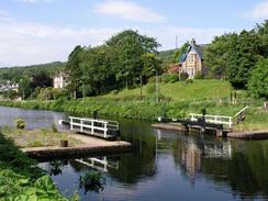
One of the high points of today was the short walk along the Crinian canal, which cuts the Kintyre peninsular off from the mainland. This canal eight and a half mile long canal was opened in 1801 to save the 130-mile trip around the peninsular. It ends on the eastern coast at Ardrishaig, and I was surprised by the width of the canal - I am more used to walking along narrow canals, and it was nice seeing yachts cruising up the canal and using the locks. It was an extremely pleasant walk up to the end of the canal, with the water glinting blue and green with the reflections of the sky and trees, and it was certainly a much better walk than the alternative of sticking to the A83(T)!
Tonight we sat on a bench at the campsite and repacked my rucksack, taking out several things that I will not be needing, This has made it feel much lighter and it now sits better on my shoulders. My shoulders have taken quite a strain today, and I hope that they feel better for tomorrow. The shower that I had tonight certainly eased them, although they were still sore, even after Sam had given them a lovely massage.
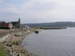
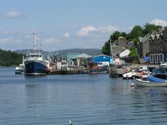
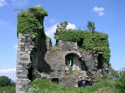
I must admit that I was very impressed with Tarbert. As I headed down the hill into the village the sun was sparkling off the blue water, and the whole place looked beautiful. It still looked nice as I got closer (which unfortunately is not always the case), and after I had slumped into Mervan and taken my pack off I was eager to explore. By now it was quite hot, and it could just be that anywhere looks lovely in the sunshine, but I do not believe that this is the case. The clarity of the water in the harbour was superb, it was a couple of feet deep but the details of the bottom could be seen exceptionally clearly. After a little rest (I felt like my shoulders were three feet lower than my hips!) we went out and had some chips from a local shop, and then ascended the steps that lead up to the fourteenth century castle that is prominent on the hillside above the village. The remnants of the castle are certainly not the most impressive ruins that I have seen on this trip, but the views from it on this sunny day were exhilarating, and well worth the climb.
Directions
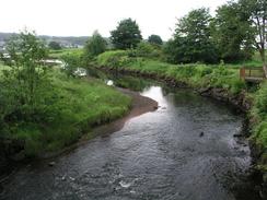
The directions for this walk are very simple; walk westwards along the A83(T) out of the village to a roundabout near the river. Here turn left but instead of following the road southward climb up an embankment onto the canal towpath, and then turn left to walk south along the canal towpath until it ends at the A83(T). Turn right and head south along the A83(T) all the way to Tarbert, and this walk ends by the quay in the village.
Distances
| From | To | Distance (m) | Ascent (ft) | Descent (ft) |
|---|---|---|---|---|
| Lochgilphead tourist information | Inverneill | 4.8 | 269 | 269 |
| Inverneill | Tarbert | 9.1 | 791 | 784 |
This makes a total distance of 13.9 miles, with 1060 feet of ascent and 1053 feet of descent.
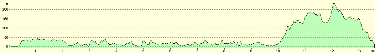
For more information on profiles, ascents and descents, see this page
Accommodation
We spent the night at the West Tarbert Holiday Park, Escart Bay, Tarbert, Argyll, PA29 6YF. This site had some lovely views over West Tarbert Loch, but unfortunately the toilets and showers were fairly manky and so we both had showers in the van. They were nice enough to knock three pounds off the price for us, and so the site cost us seven pounds for the night. They can be contacted on (01880) 820873, or on the web at www.croft-cottages.co.uk.
Disclaimer
Please note that I take no responsibility for anything that may happen when following these directions. If you intend to follow this route, then please use the relevant maps and check the route out before you go out. As always when walking, use common sense and you should be fine.
If you find any information on any of these routes that is inaccurate, or you wish to add anything, then please email me.
All images on this site are © of the author. Any reproduction, retransmissions, or republication of all or part of any document found on this site is expressly prohibited, unless the author has explicitly granted its prior written consent to so reproduce, retransmit, or republish the material. All other rights reserved.
Although this site includes links providing convenient direct access to other Internet sites, I do not endorse, approve, certify or make warranties or representations as to the accuracy of the information on these sites.
And finally, enjoy your walking!
This walk was mentioned in the following routes:
| My walk around the coastline of Britain |
Nearby walks
| # | Title | Walk length (miles) |
|---|---|---|
| 468 | Ardlamont Point to Lephinmore | 21.0 |
| 471 | Furnace to Lochgilphead | 17.4 |
| 473 | Tarbert to Dougarie Point | 22.3 |
|
|

|