Walk #473: Tarbert to Dougarie Point
 |
 |
|
General Data
| Date Walked | 15/06/2003 |
| County | Strathclyde |
| Start Location | Tarbert (Kintyre) |
| End Location | Dougarie Point |
| Start time | 10.03 |
| End time | 20.29 |
| Distance | 22.3 miles |
| Description | This was very much a walk of two halves; an initial walk from Tarbert through the woodland and over the moors to Skipness was followed by a ferry over to Arran and a long road walk south from Lochranza. |
| Pack | For the initial part of this walk to Claonaig I carried my 30-litre Karrimor HotRock rucksack, which only contained a water bottle. For the second part of the walk I carried my 70-litre Craghoppers rucksack with full camping gear, including four days food. |
| Condition | Despite the rather longer length and the fact that I carried full camping gear for a trifle under eleven miles, I feel much better after today's walk than I did after yesterday's. My shoulders are fine despite carrying the extra weight, and the only trouble that I had with the underside of my feet were a couple of sharp pains, one in each foot, and which was therefore much better than they have been. |
| Weather | Today was quite a nice sunny day, although there were significant cloudy periods. There was some breeze when I was high up on the moors, but this had died down by the time that I camped for the night. Fortunately there was no sign of any rain, and this made it an absolutely superb day for a walk. |
| OS map | Landranger number 62 (North Kintyre & Tarbert) and Landranger number 69 (Isle of Arran) |
 |
 |
|
 |
 |
|
Map of the walk
Maps courtesy of Google Maps. Route for indicative purposes only, and may have been plotted after the walk. Please let me have comments on what you think of this new format. For a detailed table of timings for this walk, please see the table file.
 |
Notes
We did not sleep very well last night, as we left the roof vent of Mervan open by mistake and the fridge light attracted midges in. At about midnight I woke up scratching myself silly, and when I got up and put the light on I could see that there was a small cloud of midges about. There was nothing that I could do to get rid of them, so I put a long sleeved shirt, leggings and socks on to reduce the amount of bare skin. This allowed me to sleep, but when I woke up in the morning there were the telltale red bumps on my skin to show that I had been bitten a lot.
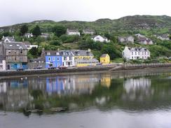
There was no particular hurry for me to set off this morning, so we set off from the campsite fairly late and drove to the car park beside the harbour in Tarbert where I finished yesterday's walk. Sam went to get a paper and whilst I was skimming through it a cyclist came up and introduced himself. He is a gent who did a 4,000-mile coastal walk a couple of years ago. We had quite a long chat, as it is intriguing to find people who have down the walk before.
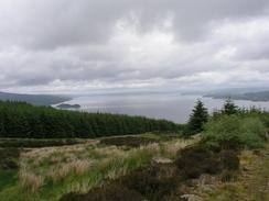
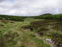
The first part of the walk past Tarbert Castle and over the moorland to Skipness was an absolutely superb walk, with some great views being available over Loch Fyne and the Isle of Bute. As I knew that I was going to have to carry a full pack in the afternoon I decided to do this stretch of the walk with only a light weight on my shoulders, so I used my 30 litre rucksack with only a water bottle in it. This stretch of the walk was one of the nicest that I have done for some time, with a marked path over the moorland. I took my time on the walk and enjoyed the nice stroll.
I eventually reached the public road in Skipness, and then had to decided what to do. I had intended to visit Skipness Castle, but it was a little way away in the wrong direction and so I chose just to meet Sam in the lay-by where she was waiting for me. I had to catch a ferry over to Arran, but the weather was good and I was in no hurry so I waited for a couple of hours and rested. There was a nearly identical N-reg Swift Royale motorhome parked next to Mervan, and whilst I waited the owner went for a dive in the water, and emerged nearly an hour later about a quarter of a mile down the coast.
I could not remain still on the ferry trip across to Arran. I was full of anticipation, and was looking forward to the challenge of a heavier pack and of camping out for three nights in a row. The ferry was the 211-ton Loch Tarbert, which had been launched in July 1992. I enjoyed the trip over, and walked around the ferry looking at all the notices. A few people on the ferry gave me donations, and when it finally docked at Lochranza I hoisted my pack onto my shoulders and set off down the road. I had wanted to do six to nine miles this evening, but in the end I felt so good that I continued on and did a little under eleven miles before I found what I thought to be an ideal place to camp. Unfortunately as soon as I threw my pack down onto the ground a large cloud of midges flew up, and this made putting the tent up highly unenjoyable.
I usually plan my walks in great detail - during the year before I set off on the walk I planned my walk around the coast and measured the route into different sections, which a computer script then converts into my itinerary. As I had not been planning to walk around Arran, however, I had not done this and consequently all I know about the walk is that it is about 56 miles along the road around the island. This lack of planning actually feels quite liberating, and I shall just take the walk around the island as it comes.
Once I had got the tent up I threw my pack inside and scrambled in myself. With the sound of sheep bleating outside I realised that a fair few midges had got inside on my pack and on my clothes, so I spent a pleasant half hour squashing the wee beasties against the side of the tent, leaving grey smudges on the yellow material. I got to be quite competent at catching them at the right moment, and I soon lost count of how many I managed to dispatch to that great midge cloud in the sky. Unfortunately I could see many more midges outside the tent, and so I did not really want to go outside and cook. This was not too important, as I had lunch quite late and had a big breakfast. I could cook inside the tent, but I try to avoid doing this for safety reasons unless it cannot be avoided.
Tonight will be the first night since mid November that I have not had Sam in bed beside me, and only the fifth night since the start of the trip that I have not slept in Mervan. This all feels very weird, but as soon as I got in my tent I settled in and felt like I was in an old home. I have not camped out in it since last June, but I have many happy memories of sleeping in this tent - I only wish that Sam could be here.
Directions
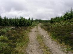
The first part of this walk from Tarbert to Claonaig follows a waymarked path called the 'Tarbert to Skipness Walk' southwards over the moorland, and the Forestry Commission publishes a leaflet on the walk. Start off near the quay in the town and then climb up steps that lead towards Tarbert Castle. Before the castle is reached a path continues southwards, marked by posts with red marks on them. When the red path turns to the left continue southwards along a path marked by blue posts for about a kilometre until a track is reached, and then turn left along this track. When the blue path turns to the left to head northwards continue along the track along a path marked by yellow posts. The track climbs uphill with some lovely views over Loch Fyne, and when the track ends the path is obvious on the ground and marked with more of the posts as it heads across some moorland.
Eventually the path plunges downhill into some more woodland, and then joins a track. The track passes through a gate in a deer fence and then continues on downhill along the western bank of the Skipness River before the B8001 road is reached in Skipness. Turn right and walk along the B8001 for a couple of miles until the ferry terminal is reached at Claonaig.
The second part of this walk is very simple; at Lochranza ferry terminal turn right and walk south along the A841 for a little under eleven miles, passing through Catacol, Pirnmill and Whitefarland along this quiet road until Dougarie Point is reached, where this walk ends.
Distances
| From | To | Distance (m) | Ascent (ft) | Descent (ft) |
|---|---|---|---|---|
| Tarbert | Claonaig | 11.5 | 1726 | 1726 |
| Lochranza | Dougarie Point | 10.8 | 1004 | 1017 |
This makes a total distance of 22.3 miles, with 2730 feet of ascent and 2743 feet of descent.
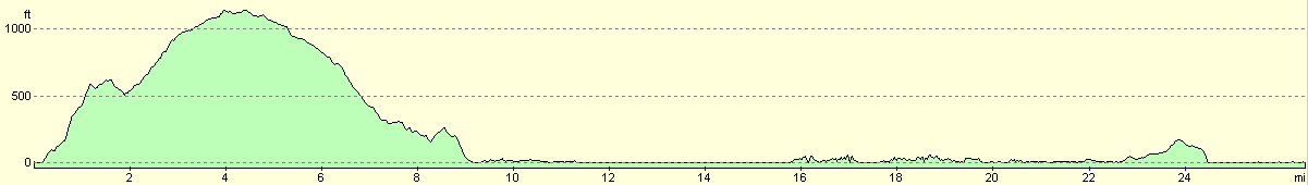
For more information on profiles, ascents and descents, see this page
Please note; this profile includes a few miles of the ferry crossing; this is the level section in the middle.
Accommodation
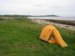
I put my tent up on a piece of flat grass between the sea and the road near Dougarie Point. This was a lovely place to camp except for the awful cloud of midges that soon came to greet me.
Disclaimer
Please note that I take no responsibility for anything that may happen when following these directions. If you intend to follow this route, then please use the relevant maps and check the route out before you go out. As always when walking, use common sense and you should be fine.
If you find any information on any of these routes that is inaccurate, or you wish to add anything, then please email me.
All images on this site are © of the author. Any reproduction, retransmissions, or republication of all or part of any document found on this site is expressly prohibited, unless the author has explicitly granted its prior written consent to so reproduce, retransmit, or republish the material. All other rights reserved.
Although this site includes links providing convenient direct access to other Internet sites, I do not endorse, approve, certify or make warranties or representations as to the accuracy of the information on these sites.
And finally, enjoy your walking!
This walk was mentioned in the following routes:
| My walk around the coastline of Britain |
Nearby walks
| # | Title | Walk length (miles) |
|---|---|---|
| 468 | Ardlamont Point to Lephinmore | 21.0 |
| 472 | Lochgilphead to Tarbert | 13.9 |
| 474 | Dougarie Point to Kildonan | 19.2 |
|
|

|