Walk #523: Sandwood Bay to Kearvaig via Cape Wrath
 |
 |
|
General Data
| Date Walked | 09/08/2003 |
| County | Highlands |
| Start Location | Sandwood Bay |
| End Location | Kearvaig |
| Start time | 08.10 |
| End time | 15.05 |
| Distance | 13.0 miles |
| Description | This was a highly enjoyable if slightly tough day, over moorland and roads. |
| Pack | Today I carried my 70-litre Craghoppers rucksack, with nearly full camping kit in. The exception was that I did not carry the tent, and carried a bivvy bag instead. As well as this I had two days food and I carried two litres of water. |
| Condition | I feel absolutely fine after this walk and I could easily have walked further if I had needed to. My left shoulder aches slightly, but not enough to overly concern me. |
| Weather | Today was another sunny day, although there was more cloud than there had been yesterday. The morning was exceedingly still that allowed the midges to bite, but the wind built up over the course of the afternoon, which when combined with the cloud helped keep the temperature down. |
| OS map | Landranger number 9 (Cape Wrath, Durness & Scourie) |
 |
 |
|
 |
 |
|
Map of the walk
Maps courtesy of Google Maps. Route for indicative purposes only, and may have been plotted after the walk. Please let me have comments on what you think of this new format. For a detailed table of timings for this walk, please see the table file.
 |
 |
|
 |
 |
|
Notes
Wow! Last time I reached Cape Wrath I got very emotional, as it was the end of an eventful three-week walk from Fort William. Reaching the cape today meant that I had completed a walk up the west coast of Britain, which was about six months and 3,200 miles of walking! I find it almost unbelievable about how long the west coast is - over half of my walk around the coastline of Britain has been on the west coast, and in comparison the north coast should only take me nine or ten days
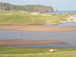
After an absolutely superb afternoon yesterday, we awoke to another sunny and clammy day, but with the added feature of a cloud of midges. This made life very unpleasant from the start, as every time we went out of the tent the midges would descend and get in. This understandably put Sam into a very bad mood, and I can hardly blame her. When breakfast time came we decided to try cooking away from the tent, but the midges soon came over to feed off us as we fed ourselves. Eventually we had breakfast finished, and we walked over to the beach, which was blissfully midge-free, for a rest.
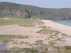
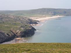
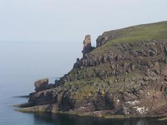
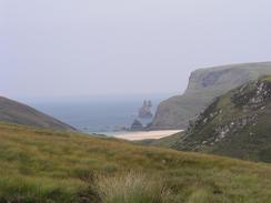
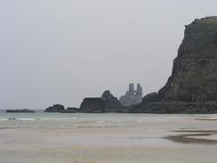
Eventually we had to go back to face the midges, and I did so with a very low heart. There were seemingly thousands of midges on my rucksack, and as it had been left open they were also inside the pack. Hurriedly I got everything in the pack, and after kissing Sam goodbye I set off on the climb up the first hill. Last time I had done this walk I had been in mist for the first couple of miles, and it was nice to have sunny, if hazy, weather that allowed me to look back over Sandwood Bay - a beautiful sight. The last time that I did this walk I had taken a slightly inland course, but this time I decided to try and stick to the coast more, which turned out well as here was an indistinct path in places. The coastal route is much better than the inland route, and there were some superb views available over the cliffs, which the path passed very close to in places.
This path took me down very steeply to meet the Keisaig River and past a little ruined building by the Bay of Keisgaig. The climb up the other side was step but easy, and I stopped or lunch at the top of the climb in the bealach between Sithean na h-lolaireich and Cnoc a' Ghubhais. I sat down on a handy pile of rocks (which was the same place where I had lunch last time I had walked to the Cape), which made me quite sentimental. As I sat down on the rocks and took my rucksack off I was filled with a sense of contentment and serenity, which is highly unusual for me, an I knew that absolutely nothing would stop me from reaching the Cape now. Instead of heading back around the coast I decided to walk almost directly north across the moorland to the road, which was an easier if less coastal route. The moorland as easy going and enjoyable, and I soon fund myself at the road, which I followed for a little over a mile to the Cape Wrath lighthouse.
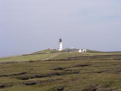
Reaching the Cape was a significant milestone for a couple of reasons; firstly, it was the place that I finished my long walk from Fort William to Cape Wrath last year, and therefore has some great memories for me; and secondly it means that I have completed the west coast of Britain, after 3,273.4 miles and six months three days. I find this figure quite amazing, and I can hardly believe that it has been that long since I turned right at Land's End! I walked to the lighthouse and took my pack of, which were rapidly followed by my boots as my feet were overheating. I sat on the floor and thought about all those miles, which caused very mixed emotions - pride at having completed it tinged with sadness at leaving the west coast behind. After ten minutes I put my boots back on, and as the minibuses disgorged another load of tourists I set off up the hill to have a look around the remnants of the old coastguard station nearer the top of the hill, where lookouts used to watch ships turning the cape before they were superseded by radar in the fifties. It must have been quite a lonely and exposed posting, but I could imagine that it would have had high points as well - the sunsets over the cape must be fantastic.
I soon realised that I had to go, and so I set out on the last few miles along the road. I have since found out that it is more than possible to walk along the cliffs to the bothy from the lighthouse, and that gives me another excuse to come to this lovely place. Just before I reached the descent to the bothy one of the minibuses pulled up beside me, and the man inside gave me a little certificate saying that I had been to the lighthouse, and a mobile phone that had been dropped by someone staying at the bothy. The descent down to the bothy was along a rough track, and when the bothy came into view I was quite happy that the day's walk was over.
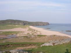
Four people were staying at the bothy tonight - David and John Arnott, Gerald Edmonds (midge killer extraordinaire), and Janice Clark - a good set of people. Janice was accompanied by Ossie the Alsatian, a good fifth member of the troop. We all had a truly excellent evening and they were all exceedingly good company, and the evening was topped off by a late night walk around the beach at Kearvaig, which is nestled in a beautiful stretch of coastline. This was truly one of the best evenings that I have had for some time, and it makes me realise how much I miss bothying - something I have not done much of on this trip. The bothy is actually quite a large example, with over four rooms and a nice fireplace in which we had a roaring fire. There was a significant breeze this evening, and so we were not attacked by any midges, although apparently they were very bad this morning.
There is a very sad story about Kearvaig bothy - just before Christmas last year a lady starved to death whilst staying there on a walk to Cape Wrath. It is believed that she had been there for two or three weeks before two shepherds found her in the bothy. She was still alive, and they alerted a sentry in the MOD sentry box at the top of the hill, who called in a helicopter. Sadly she died in hospital a couple of days later from hypothermia. There seem to be many versions of this story about, but whatever the truth it was an exceedingly tragic event. Janice actually knew the lady, and the whole purpose of her visit to Cape Wrath was to see the place where her friend died. This story just shows how remote this area gets in winter - I cannot imagine the bothy being unused for such a long period in spring or summer.
Directions
This walk starts off at the northeastern corner of Sandwood Loch, on the eastern side of the river that runs between the loch and the sand dunes. The route to be taken is mostly indistinct and unpathed, so the following is only a guideline and it may be best to try and make your own route. One fact remains constant, however; staying close to the coast gives a dryer route whilst inland the ground is far boggier and harder going. However diversions inland are necessary for the couple of rivers that need crossing, and the cliffs can be steep and dangerous, so care is needed.
I started of by climbing the steep hillside that it is to the eastern side of the river. The nearer to the sea that you attempt to climb it the steeper it is; for this reason I chose to start the climb a couple of hundred yards inland near the northern tip of the loch. The climb is steep but relatively short, and I found it a fairly easy climb even with my pack on. Once at the top I started angling back towards the coast, heading northwestwards.
After about a mile the Strath Chailleach is reached. I crossed this slightly inland where the descent down to the river and ascent up from it are far easier and less dangerous than it would have been nearer the sea. The crossing was fairly easy, with a rocky river bed allowing a stepping-stone approach to be used, although I can imagine after heavy rainfall this would become a far more complex matter.
Once I had ascended up from the river I passed the coastal side of the Cnoc a' Gheodha Ruaidh hill, where there was the semblance of a path skirting the hillside. A minor descent is then followed by an ascent as the path ends, and this is followed by an ascent up on the seaward side of another minor hill where as I recall the path became indistinct in places.
This is followed by a long descent along the cliffs down towards the Keisgaig River. There are two ways up from the river, and it is probably best to decided which you are going to do before you start the descent; you can try and cross near the Bay of Keisgaig by a strange stone building, where there is a stream running down the northern flank of the river which can be followed up; or you can do what I did on a previous trip and head further inland to another stream which can be followed. The advantage of the former route is that it is shorter but it has a steep, almost scrambling bit down past the hut, and it involves more climbing; the advantage of the latter route is that it does not climb as far, does not involve scrambling but it is a slightly longer route and the ground on the southern side of the river is fairly boggy. Having done both of these I would definitely say the former route is better, despite the fact that it involves more climbing.
Once you have crossed the river, you have a choice; you can apparently follow the cliffs northwards to the Cape (I have never done this route), or you can ascend up the northern flank heading for the bealach between the hills of Sithean na h-lolaireich and Cnoc a' Ghiuihais. This is a steep ascent that tired me out, so I had a little rest at the top of the saddle, where there were some lovely views available. From the saddle starts descending northeastwards. The route that I took soon turned to head northwards across the moorland, passing to the east of the river that runs to the east of the hill of Dunan Beag. As we neared the road a last stream had to be crossed and we hit the road near the top of the western ascent from the inlet from Clais Charnach.
Once the road is met the route is simple; just turn left and follow the road as it skirts around the hill of Dunan Mor for a little over a mile until the lighthouse complex of Cape Wrath is reached. The route from Sandwood Bay to Cape Wrath is mentioned in the excellent book "North to the Cape", by Denis Brook and Phil Hinchliffe, Published by Cicerone Press, and ISBN 1-85284-285-7.
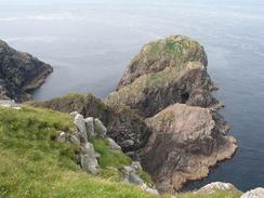
From Cape Wrath you again have a choice; there is a demanding cliff top walk from the lighthouse along the cliffs past Dunan Mor to Kearvaig, which is doable but tricky in places (again I have never done that walk). Instead you can do a longer but easier route, following the road as it heads southeastwards from the lighthouse for four and a half miles. It dips down into the little valley of the Clas Charnach, before rising up and contouring for a while before descending to cross the Kearvaig River. The road then climbs up on the other side and by a black hut a track leads off to the left. Follow this track as it descends for about a kilometre to Kearvaig bothy, where this walk ends.
For details of an lovely walk from Kildonan to Cape Wrath, have a look at Lizzie and Andrew Smith;s webpages at http://www.lizzieandrew.pwp.blueyonder.co.uk/.
Distances
| From | To | Distance (m) | Ascent (ft) | Descent (ft) |
|---|---|---|---|---|
| Sandwood Bay | Cape Wrath | 7.7 | 1690 | 1329 |
| Cape Wrath | Kearvaig | 5.3 | 505 | 774 |
This makes a total distance of 13.0 miles, with 2195 feet of ascent and 2103 feet of descent.
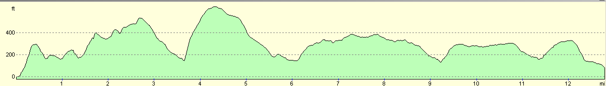
For more information on profiles, ascents and descents, see this page
Accommodation
I spent the night at Kearvaig Bothy, a lovely place to spend the night, which is situated a few miles to the east of Cape Wrath.
Disclaimer
Please note that I take no responsibility for anything that may happen when following these directions. If you intend to follow this route, then please use the relevant maps and check the route out before you go out. As always when walking, use common sense and you should be fine.
If you find any information on any of these routes that is inaccurate, or you wish to add anything, then please email me.
All images on this site are © of the author. Any reproduction, retransmissions, or republication of all or part of any document found on this site is expressly prohibited, unless the author has explicitly granted its prior written consent to so reproduce, retransmit, or republish the material. All other rights reserved.
Although this site includes links providing convenient direct access to other Internet sites, I do not endorse, approve, certify or make warranties or representations as to the accuracy of the information on these sites.
And finally, enjoy your walking!
This walk was mentioned in the following routes:
| My walk around the coastline of Britain |
| My sectional Land's End to John O'Groats walk |
Nearby walks
| # | Title | Walk length (miles) |
|---|---|---|
| 201 | Rhiconich to Sandwood Bay | 12.8 |
| 202 | Sandwood Bay to Cape Wrath | 7.7 |
| 522 | Rhiconich to Sandwood Bay | 12.5 |
|
|

|