Walk #524: Kearvaig to Durness
 |
 |
|
General Data
| Date Walked | 10/08/2003 |
| County | Highlands |
| Start Location | Kearvaig |
| End Location | Durness |
| Start time | 08.10 |
| End time | 19.19 |
| Distance | 23.8 miles |
| Description | This was an absolutely superb day's walk, over a mixture of road, paths and unpathed terrain, with some exhilarating views available along the Kyle of Durness and the north coast of Scotland. |
| Pack | For the first part of today's walk I carried my my 70-litre Craghoppers rucksack, with nearly full camping kit in. The exception was that I did not carry the tent, and carried a bivvy bag instead. As well as this I had two days food and I carried two litres of water. At the Cape Wrath Hotel I thankfully discarded my large rucksack and walked the rest of the way wearing a bumbag that contained a litre of water. |
| Condition | I feel absolutely fine after this walk, and have no significant problems to report. The only minor niggle is that a toe on my left foot ached, probably as a result of having had sand in my shoe. |
| Weather | Today started off very unpromising; it was grey and overcast overhead, and there was no wind and so the midges were out in force. As the day went on the clouds started to dissipate and were replaced with bright sunshine and only occasional clouds. Coupled with this it got reasonably warm, but not too hot due to the cloudy morning. |
| OS map | Landranger number 9 (Cape Wrath, Durness & Scourie) |
 |
 |
|
 |
 |
|
Map of the walk
Maps courtesy of Google Maps. Route for indicative purposes only, and may have been plotted after the walk. Please let me have comments on what you think of this new format. For a detailed table of timings for this walk, please see the table file.
 |
 |
|
 |
 |
|
Notes
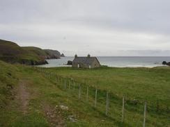
I woke up this morning with a strange feeling of not knowing where I was. Light was streaming through the skylight window of the room, and after a confused couple of minutes I realised that I was in Kearvaig Bothy. There seemed little reason to lie in bed, so I pulled on my clothes quietly so as not to disturb the other gent in the room, and went downstairs. John was already downstairs, and we chatted as I started my cooker and made coffee. Unfortunately I needed to take a break for a call of nature, so I decided to go as I was waiting for the coffee to cool. As soon as I went outside the door the midges attacked me, and although I jogged up the hill when I reached a suitable place away from the bothy my hands, arms and face were covered in the wee beasties. I do not think that I have ever willed myself to finish a call of nature so quickly, and I ran back down the hill with my arms flailing around my head to try and brush off the midges before I re-entered the bothy.
After a while everyone else started to get up, and we soon had a crowded room downstairs. Unfortunately everyone else had to go to the toilet, and so slowly a small group of midges built up inside the bothy, waiting to catch the unprepared. Eventually Ossie the Alsatian was let out, and when he came back his fur was grey with midges. Midge coils were rapidly lit, and whilst the situation in the main room was okay, in the corridor by the exterior door there was a cloud of midges. Whenever anyone opened the door into the corridor Ossie would run out, and when he came back in he would bring yet more midges back in on his fur.
Eventually I packed everything up and got ready to face the midges. With my pack high on my back and my midge net obscuring my face I looked quite a sight, but I did not care because it would protect me from the beasties a little. I then went out into the midgeiverse that was the outside of Kearvaig Bothy. The midges were with me until near the top of the long climb out of the bothy, and I was glad when I could finally take the midge net off - it is not nice breathing heavily through them, especially when there are splattered midges right by my mouth on the net.
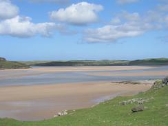
The seven miles towards the ferry jetty went quickly, and the only thing of any note was the new bothy that has been opened next to the bricked-up house at Inshore - this could be useful on future trips. Just before I reached the descent down to the jetty I took a clear track that headed uphill, and from there I followed sheep tracks southwards along the western short of the Kyle of Durness. Sam was visiting Cape Wrath whilst I was walking, and I could see Mervan waiting by the Cape Wrath Hotel on the other side of the Kyle. The moorland was firm and dry but slightly uneven and so progress was slow, but I enjoyed the views of the Kyle, with the tide going out and exposing ever larger sand flats.
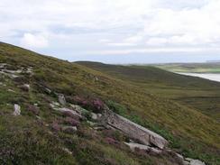
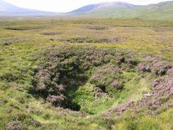
Despite this I was relieved when I finally reached the Grudie River, over which there is a bridge marked on the map. I could see a structure that could have been the bridge some way off, but I found an earlier way across by scrambling across some rocks. After this I had to climb up over Sithean Mor - I could have walked around the little peninsular by the farmstead at Grudie, but I could not be bothered. On top of Sithean Mor I came across some strange circular depressions - the first that I came across was about fifteen foot wide and ten feet deep. I thought that this may have been a sinkhole, but the rocks did not look like limestone (although it was hard to tell under the heather). A few minutes later I cam across many more of these, and they have intensely puzzled me - my best guess is that they are old bomb craters, but I cannot guess why they would have been shelling the eastern slope of that hill.
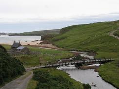
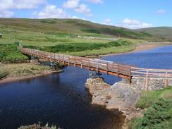
I had a rest on the eastern side of the nice bridge over the River Dionard and I ate the remainder of my food - two mars bars, my first food of the day and I therefore wolfed them down ravenously. The next three miles to Mervan were along the A838 road, which was a pleasant plod that was hard on my feet. When I eventually reached Mervan I was glad to be able to shed my pack and sit down. Sam was still not back from the Cape, and so I took my boots off to give my feet a rest and started to read yesterday's paper. As I was hungry I also sneaked out a couple of biscuits, and whilst these did not totally stop my hunger they at least stopped it rumbling.
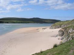
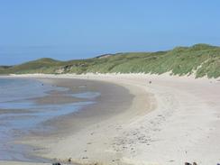
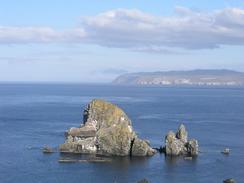
Suddenly there was a knock on the door, and when I opened it I could see Gerald standing there. He and Janice were having a drink in the hotel bar, and he invited me up to join them. I did not want to start the last section of today's walk until Sam got back from the Cape, and so I went up with him and had a couple of drinks whilst we chatted away. This camaraderie of the trail is a marvellous thing, and it is so lovely to meet nice people such as these two. When Sam arrived we had another drink and then went back to Mervan. My right shoulder was aching from the load of the rucksack, and so I decided to do the last few miles wearing a bumbag with a water bottle in instead. I had expected the walk around Faraid Head to be about six miles, but I had not measured it and it turned out to be over nine! The walking was absolutely first class, however, and it was the clearest day for some time and the views were superb. On the first section I was wading through knee-deep Marram grass, and after a while I could see some white cotton on my trainers. Thinking that I had picked up some cotton out of the grass I pulled it off, only to find that the razor-sharp Marram grass had shredded my shoelace! The beaches down the western side of Faraid Head were beautiful, and behind the beach there are some high sand dunes with glistening white sand. From near Faraid Head itself I believe that I could make out Dunnet Head fifty or sixty miles away to the east, a fantastic sight. Unfortunately I could not access the area of land around Faraid Head itself as it is MOD land - it has buildings on it that are part of the bombardment range, and this is a shame as the views from this higher area must be even better than the ones available lower down the hillside.
By the time that I got back to Mervan dinner was ready, and Sam had cooked a mouth-watering meal of sausages and mash for me. I was ravenous, and I wolfed the meal down quickly. We had agreed to meet Janice and Gerald in the pub adjacent to the campsite, and we had a lovely chat, although I left early as I was absolutely shattered, while Sam stayed on. I have decided to take a day off tomorrow, mainly so that I can have a rest and get a website update done.
 |
Directions
This walk starts off at the Kearvaig bothy, about four kilometres southeast of Cape Wrath. Leave the bothy and follow the track northeastwards uphill for about a kilometre to a T-junction with a road. Turn left and follow this road as it heads souteastwards across the moorland, passing Loch Inshore before finally descending downhill along the valley of the River Daill to Daill. Cross the river on a surprisingly old temporary bridge and follow the road as it climbs uphill on the other side through Achiemore. It then heads southwards along the western side of the Kyle of Durness for a couple of kilometres until just before the road starts to descend to the ferry jetty.
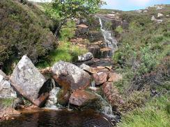
Immediately before the descent a very rough track leads off to the right. Follow this track steeply uphill as it heads south, passing to the right of a little hillock before the track eventually runs out. Instead of heading further down the side of the valley I kept high up, only descending when some stone walls marking field boundaries appear on the valley floor. Cross a lovely stream immediately before the walls. Do not enter the fields but continue on southwestwards until they end, and then start to head down towards the Grudie River. Once the river's tidal limit is reached cross the river (if it is in spate then there is a bridge further upstream), and then turn left to had southeastwards over the top of Sithean Mor and then descend downhill to a farm and a bridge over the River Dionard.
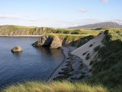
Cross the bridge and then go up a short track that ends at the A838 road. Turn left and head north up the eastern bank of the Kyle of Durness for about three miles, until a road junction is reached on the left. Turn left down this road for a little under a kilometre as it passes the Cape Wrath Hotel and ends at a ferry jetty. At the jetty take a footpath that leads around the coast for a couple of miles to Eilean Dubh; in most places the path is very distinct but in others, particularly in the areas of Marram grass, it is indistinct. Near Eilean Dubh the path turns to the right and heads eastwards for about a mile, passing through a golf course before reaching a car park beside the ruined church in Balnakeil. At the car park join a lovely beach and head northwards along it, and at the northern end follow a tarmac path over a little hill, and on the other side descend down onto another beach.
Walk along this beach northwestwards, and at the northern end of it climb uphill and follow the edge of the cliffs around to a point, where it turns to head eastwards, climbing uphill towards Faraid Head. Before you reach the very top of Faraid Head an MOD area is reached, so skirt around the fence of this area until the cliffs on the eastern side are reached. Turn right and head to a cairn, and continue around the edge of the cliffs towards Aodann Mhor, and then take a footpath that head south, becoming a track that heads south. You can follow the track to the road in Durness and then turn left to head eastwards to the campsite in Durness, where this walk ends. Alternatively you can go through three gates to cut across from the track to the campsite.
Distances
| From | To | Distance (m) | Ascent (ft) | Descent (ft) |
|---|---|---|---|---|
| Kearvaig bothy | Track near jetty | 7.2 | 869 | 787 |
| Track near jetty | Bridge over River Dionard | 3.5 | 535 | 689 |
| Bridge over River Dionard | Cape Wrath Hotel | 3.6 | 266 | 269 |
| Cape Wrath Hotel | Durness campsite | 9.5 | 1329 | 1253 |
This makes a total distance of 23.8 miles, with 2999 feet of ascent and 2998 feet of descent.
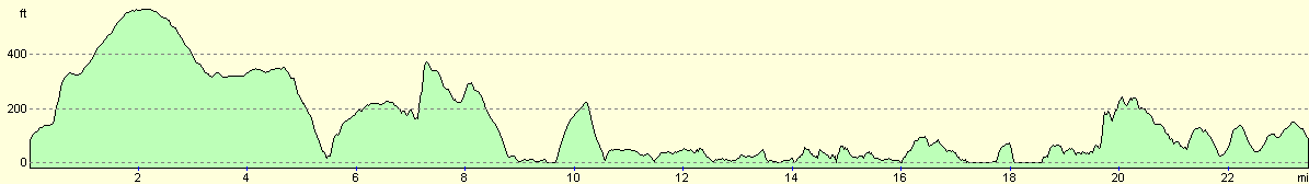
For more information on profiles, ascents and descents, see this page
Accommodation
We stayed at the Sango Sands Caravan and Camping Site, Durness, Highlands IV27 4PP, telephone (01971) 511262 or (01971) 511222. This site sot us ten pounds twenty-five a night for two nights, and had reasonable facilities, although the location is excellent, with some beautiful beaches a stones throw away.
Disclaimer
Please note that I take no responsibility for anything that may happen when following these directions. If you intend to follow this route, then please use the relevant maps and check the route out before you go out. As always when walking, use common sense and you should be fine.
If you find any information on any of these routes that is inaccurate, or you wish to add anything, then please email me.
All images on this site are © of the author. Any reproduction, retransmissions, or republication of all or part of any document found on this site is expressly prohibited, unless the author has explicitly granted its prior written consent to so reproduce, retransmit, or republish the material. All other rights reserved.
Although this site includes links providing convenient direct access to other Internet sites, I do not endorse, approve, certify or make warranties or representations as to the accuracy of the information on these sites.
And finally, enjoy your walking!
This walk was mentioned in the following routes:
| My walk around the coastline of Britain |
| My sectional Land's End to John O'Groats walk |
Nearby walks
| # | Title | Walk length (miles) |
|---|---|---|
| 201 | Rhiconich to Sandwood Bay | 12.8 |
| 202 | Sandwood Bay to Cape Wrath | 7.7 |
| 522 | Rhiconich to Sandwood Bay | 12.5 |
|
|

|