Walk #537: Dornoch Bridge Inn to Rockfield
 |
 |
|
General Data
| Date Walked | 25/08/2003 |
| County | Highlands |
| Start Location | Dornoch Bridge Inn |
| End Location | Rockfield |
| Start time | 09.52 |
| End time | 17.57 |
| Distance | 20.9 miles |
| Description | This was a highly enjoyable walk of two halves; a long road walk eastwards through Tain to Inver, was followed by a lovely walk along beaches and cliffs to Portmahomack, Tarbat Ness and finally Rockfield. |
| Pack | I used my new Highlands water hydration pack, which contained a two-litre water bottle, some spare batteries and a couple of chocolate bars. |
| Condition | I feel absolutely fine after this walk, and I have no significant problems to report. My right foot, which gave me much trouble on my day off yesterdays, thankfully behaved itself far better today. |
| Weather | Today was an absolutely lovely day; the wind that had dominated the last week had died down, and once the early morning cloud had lifted there was bright sunshine for most of the day. It got quite warm in the afternoon, and I was thankful that I took my fleece off at lunchtime. |
| OS map | Landranger number 21 (Dornoch & Alness, Invergordon & Tain) |
 |
 |
|
 |
 |
|
Map of the walk
Maps courtesy of Google Maps. Route for indicative purposes only, and may have been plotted after the walk. Please let me have comments on what you think of this new format. For a detailed table of timings for this walk, please see the table file.
 |
 |
|
Notes
Yesterday I took another day off, obstentially so that I could visit the Glenmorangie Distillery, which is a mile and a half down the road from the campsite that we were staying at. Glenmorangie is my favourite whisky, so I very much enjoyed the tour of the distillery, and I particularly enjoyed the little tasting session afterwards! I had promised myself this visit since before I started this trip, and it was nice to finally get it done.
What was not so nice was the fact that I had a fairly serious problem with my right foot on the walk to and from the distillery. Ever since I twisted my right ankle after my climb up Scafell Pike I have had occasional twinges of pain from the side of my right foot, usually when I do not have my trainer tied up. Unfortunately all day yesterday my right foot was giving pain when I walked, and this very much concerned me, as I found even the one and a half mile walk to the distillery to be nearly more than I could cope with.
I set off this morning with this very much in the back of my mind, and I was concerned when, after five minutes along the A9(T),I got a serious twinge from the foot. Fortunately after this it seemed to settle down, and I reached Tain in good time. I had a quick look around the little town, which was quite an attractive little place that is dominated by two structures; the beautiful old tollhouse and a memorial by the rose gardens. After this, however, things fell apart slightly. I headed down from the centre of the town past the station towards the golf course. I then prevaricated about whether I should try and cross the golf course beside the railway line, cross a stream using a rather dilapidated suspension bridge, or head back into the town and make my way eastwards from there. I probably wasted twenty minutes walking around trying to find the best route, before eventually deciding to cross the suspension bridge and walking along from there. I am not sure why I prevaricated in this manner; I can only assume that I was unsettled in the back off my mind and that this had dented my confidence.
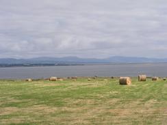
Eventually I made my way to the road, and headed on a long plod eastwards past Morrich More. This large area to the north of the road is an RAF bombing range and is barred to the public; this is a shame as it looks as though it would be a lovely walk. Eventually I could make my way northwards to the lovely little village of Inver, where I could join the beach and follow it eastwards into Portmahomack. This village is the only village on the east coast of Scotland that faces westwards, and it was absolutely beautiful in the sunshine. Sam was waiting for me there, and I had lunch whilst looking out over the beach and across the Dornoch Firth.
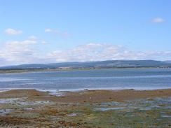
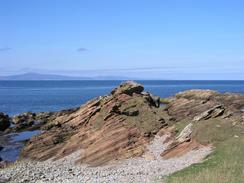
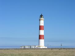
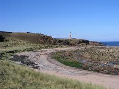
After lunch I passed the superb little harbour and walked onto the top of the low cliffs. The views from the top were exquisite, with the coast that I had walked down last week clearly visible across the Dornoch Firth. I took my time over this stretch of the walk, as the views were so lovely, and at times descended down to the rocky foreshore to do a little scrambling. I eventually reached the attractive lighthouse at Tarbat Ness, and I stopped here for a few minutes to chat to a couple that were visiting the lighthouse. The lighthouse is of what I call a classical design, and looks exactly what a lighthouse should look like, with a tall and slender cylindrical tower reaching up into the sky. I could not help but look up at it as we chatted, absorbed by the simple beauty of its design.
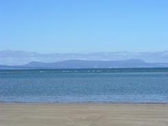
The rest of the walk was along the foreshore southwestwards to the pretty little hamlet of Rockfield, and this was an enjoyable walk with some good views over Cromarty Firth, with some stored oilrigs visible in the distance. There was a clear and very distinct path, and this allowed me to make good time when I was not looking back over my shoulder at the beautiful views along the base of the cliffs.
I phoned Sam to tell her that I would walk back the short distance from Rockfield to Portmahomack if she wanted, but she said that she did not mind picking me up. It turns out that she had been sitting outside the pub in Portmahomack chatting to people in the sunshine all afternoon. As soon as we parked Mervan back in the car park we went to the pub, and I ended up having a couple of pints bought for me, which was extremely nice. Unfortunately as I was slightly dehydrated these went straight to my head and I started to feel very sleepy. One of the ladies, Liz, invited us back for dinner, and so a eight we walked the couple of hundred yards to her house where we were entertained by Liz and her husband, John. It was yet another example of the acts of kindness that have made this walk such a great experience, and made a lovely change from having dinner in Mervan.
I was feeling extremely tired after I had finished the wonderful dinner, and so I said my apologies and went back down the road to Mervan, leaving Sam chatting away to Liz and John. When I got back to Mervan the lights of the harbour were shining beautifully off the sea, so I got my tripod out and went down onto the beach to take some long exposure photos. This was a lovely end to a superb evening, although I was very glad to get to bed and sleep.
Directions
This walk starts off at the campsite by the Dornoch Bridge Inn to the northwest of Tain. Leave the caravan park and go up to join the A836 road, and turn left to walk eastwards for a few yards to a large roundabout with the A9(T). Continue straight on and follow the A9(T) for a couple of miles as it passes the Glenmorangie Distillery and when the junction with the B9174 road is reached turn left and follow it into the centre of Tain. In the centre turn left to walk down towards the station, but before the station is reached turn right and follow a road over a bridge over the railway line. On the northern side of the railway head straight on to a suspension bridge over the River Tain near the ruins of St Dutbus's Chapel.
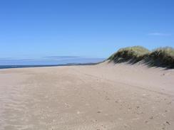
Cross the suspension bridge and then walk along a path beside the beach northeastwards for a couple of hundred yards until Plaids is reached. Join the road and follow it southwards across the golf course and over the river once more towards a low bridge under the railway line. Here turn left and go through a gate to follow the railway line southeastwards. When a road bridge over the railway line is met turn left and climb up onto the bridge and then start following the road eastwards. After a few miles when a road junction leading to Inver is met on the left turn left and follow the road into Inver. At the northern end of the village follow the road around to the right and continue on eastwards through Skinnerton. When the road ends continue on along a track behind the sand dunes, and when this ends walk onto the beach and follow this eastwards.
Cross a stream and continue on eastwards along the beach; the beach eventually becomes less sandy and rockier, at which point a path starts running immediately behind the beach. Follow this path northeastwards for a little over a mile until it ends at a road. Join the road and follow it eastwards for a short distance until it ends at the B9165 road in Portmahomack. Turn left and follow the B9165 road north through the village and towards the harbour. At the harbour turn right to head uphill along a road that soon ends by a playground. Continue straight on along a path that skirts the top of the cliffs northeastwards, and then descend down onto the foreshore beneath the base of the cliffs. From here simply follow a path that is indistinct in places past Port Mor and Port Buckie until the lighthouse is reached at Tarbat Ness.
At Tarbat Ness join a track that heads southwestwards for a few hundred yards towards a car park. At the car park join a road and follow it southwestwards for about a hundred yards until it turns sharply to the right; here turn left and follow a track that descends down towards an old jetty. At the jetty turn right along a path that follows the base of the cliffs southwards; at one point it climbs up onto the top of the cliffs for a few hundred yards (here as it was low tide I continued along the base of the cliffs) before descending back down onto the foreshore. Continue along the path, which is fairly distinct and easy going, as it heads under the restored Ballone Castle and reaches the jetty in Rockfield, where this walk ends.
Distances
| From | To | Distance (m) | Ascent (ft) | Descent (ft) |
|---|---|---|---|---|
| Dornoch Bridge Inn | Tain | 2.9 | 115 | 62 |
| Tain | Inver | 7.0 | 144 | 220 |
| Inver | Tarbat Ness | 7.3 | 256 | 236 |
| Tarbat Ness | Rockfield | 3.7 | 171 | 184 |
This makes a total distance of 20.9 miles, with 686 feet of ascent and 702 feet of descent.
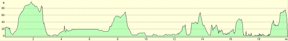
For more information on profiles, ascents and descents, see this page
Accommodation
We spent the night in a car park beside the beach at Portmahomack, which was a lovely place to spend the night and was very convenient for the nearby public toilets.
Disclaimer
Please note that I take no responsibility for anything that may happen when following these directions. If you intend to follow this route, then please use the relevant maps and check the route out before you go out. As always when walking, use common sense and you should be fine.
If you find any information on any of these routes that is inaccurate, or you wish to add anything, then please email me.
All images on this site are © of the author. Any reproduction, retransmissions, or republication of all or part of any document found on this site is expressly prohibited, unless the author has explicitly granted its prior written consent to so reproduce, retransmit, or republish the material. All other rights reserved.
Although this site includes links providing convenient direct access to other Internet sites, I do not endorse, approve, certify or make warranties or representations as to the accuracy of the information on these sites.
And finally, enjoy your walking!
This walk was mentioned in the following routes:
| My walk around the coastline of Britain |
Nearby walks
| # | Title | Walk length (miles) |
|---|---|---|
| 535 | Littleferry to Meikle Ferry | 21.1 |
| 536 | Meikle Ferry to Dornoch Ferry Inn | 27.6 |
| 538 | Rockfield to Arabella | 19.3 |
|
|

|