Walk #911: Hereward Way: Oakham to Stamford
 |
 |
|
General Data
| Date Walked | 25/07/2011 |
| County | Cambridgeshire, Rutland, Northamptonshire |
| Start Location | Oakham |
| End Location | Stamford |
| Start time | 08.21 |
| End time | 14.42 |
| Distance | 16.5 miles |
| Description | This was an enjoyable stroll along the westernmost stretch of the Hereward Way. It passes the northern shore of Rutland Water before passing through a series of picture-perfect villages to reach the exquisite town of Stamford. |
| Pack | Today I carried my 30-litre Karrimor rucksack, filled with water, my waterproofs, a couple of books and other odds and ends. |
| Condition | I feel absolutely fine after this walk. |
| Weather | The weather today was consistently cloudy, with scarcely any glimpse of the sun. Despite this it was a a good day for a stroll, and it never got too hot. |
| OS map | Landranger number 141 (Kettering, Corby & surrounding area) |
 |
 |
|
Map of the walk
Maps courtesy of Google Maps. Route for indicative purposes only, and may have been plotted after the walk. Please let me have comments on what you think of this new format. For a detailed table of timings for this walk, please see the table file.
 |
 |
|
Notes
I wanted to do a walk today, but for various reasons I could not stray too far from home this week. After a little thought my mind wandered to the Hereward Way, a little-known trail that runs from Oakham to a little station in the middle of nowhere in Norfolk. I had done the trail before in sections, most of which were over ten years before. Most of the trail was not too familiar and, best of all, most points on it were within an hours' drive.
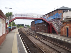
A quick run up the A1 saw me get to Stamford Station a little after seven in the morning. Then there came the first pleasant surprise of the day - parking in the station car park cost just two pounds for the day, far cheaper than most car parks. It was then a little wait for the train, which dropped me off at the station in Oakham after eight.
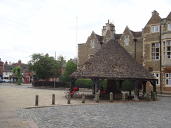
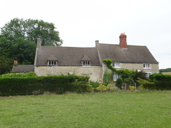
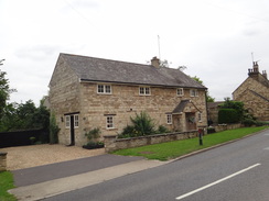
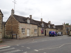
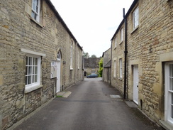
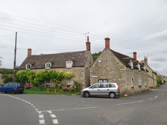
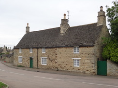
I love Oakham. Indeed, I have a rather worrying fondness for the entirety of the tiny county of Rutland. The centre is filled with streets of small houses, all of a rosy stone that makes them resemble Cotswold villages. And no wonder - the local limestone is an outcrop of the same stone that next protrudes in Gloucestershire. Even the traffic problems in the town have been somewhat eased by a new bypass.
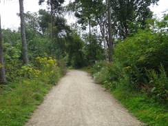
As usual with small trails, there was no signpost or marker denoting the start of the trail. The level crossing immediately to the south of the station seemed as good a place as any, and soon I was strolling slowly down a street away from the main road. The trail squeezed along two sides of the church before heading across parkland, with the mound of the castle (now sans stonework) a few yards away.
A long road led past more houses, sadly less picturesque than those in the centre of the town, to reach the new bypass. As usual I had a slightly disorientated feeling when I come across a road not marked on my now-ancient OS map, even though I had walked this way before. It proved easy to cross and soon I was descending past a characteristically stinky sewage farm to reach the main road.
Here the Hereward Way joined the better-known Viking and Macmillan Ways for the rest of the day. Perhaps this was the reason that I did not see a single Hereward Way marker within Rutland - people can just follow the many Macmillan Way ones. Unfortunately the three trails chose to leave Oakham using a cycle path alongside the main road - hardly an inspiring start to a trail, or a midpoint for that matter.
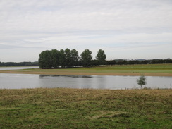
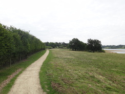
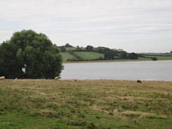
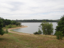
Things improved after a couple of miles, when the cycle path dived off to join the banks of Rutland Water. The path is part of a long circular route around the man-made reservoir that seems to take up most of Rutland. The reservoir gets so busy on a sunny summer's weekend that I think the population of the county must double! On this cloudy Monday I could see a few boats out on the water and a few families cycled past. As always it was a pleasant stroll on good paths, with occasional glimpses out over the water.
I stopped to chat for a few minutes to man who was waiting for a fly-fishing experience. It was his first time fishing and he fidgeted nervously as we talked. Quite what a fishing experience entails I cannot guess, but I doubt that it is action-packed. Soon afterwards I entered the first of the large car parks that dot the sides of the reservoir. All of these have identically-designed cafe and toilets blocks, although the cafe in this one was shut.
A good stroll through some broad-leaved woodland took me out to the next car park at Whitwell, and the cafe here was open. This proved too tempting to ignore and I went in to order a bacon and egg baton, then sat outside. I had been sweating in my fleece, so I took it off and instantly felt chilled as the slight breeze hit my damp skin. The sandwich was filling and I was well and truly sated when I set off once more.
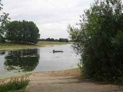
Whitwell has a little adventure area where you can hire bikes or keep your children occupied for half an hour by sending them up a climbing wall. I ignored all of these and strode on to the shoreline of Whitwell creek. I went slightly off course through the car park, but the diversion rewarded me with good views over the water towards the Limnological Tower that protrudes from the middle of the reservoir. I had always assumed that this was a place where they drew water out of the reservoir, but it looks as though it is where they sample the waters.
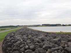
Soon afterwards I reached the rock-lined dam that stretches across the valley. Here the trails say goodbye to the reservoir; the dry face of the dam slopes gently down and, aside from the rock rip-rap at the top, appears natural. Only the presence of some concrete trig pillar dating from the construction of the dam shows that the entire slope is man-made.
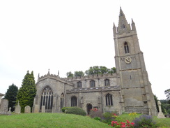
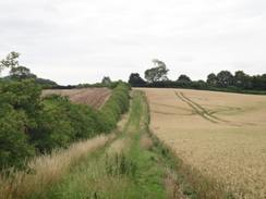
A rather bitty path took me back to the main road on the outskirts of the village of Empingham. This also had rather nice stone houses set around the dominating church, although the houses further out were of more pedestrian construction. I had walked this part of the route four or five times before and I felt like I was an autopilot as I strode along. The next stretch was perhaps the least good (worst is hardly apt) of the day; long paths that took me southwards and then southeastwards towards the next village, Ketton.
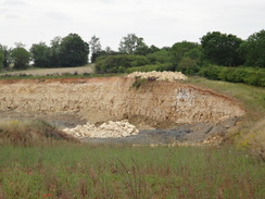
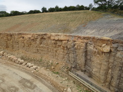
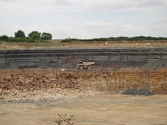
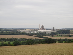
On the way I met a couple who were walking the Macmillan Way. They had set off from Boston a couple of days before and had found that stretch of the trail utterly underwhelming - 'all flat drainage channels'; they were therefore enjoying this stretch of the trail all the more. Soon afterwards I came across the massive Grange Top Quarry, which was noticeably much more massive than the last time I had walked the route. Indeed, the old path was now subsumed within the quarry and a diversion took me around the edge. I could just about make out where the old path had gone, and this was now well within the quarry. On my previous walk the path had squeezed on a high shelf between two parts of the quarry, and I noted that it was obviously only a matter of time before it went as well.
I had expected the diversion to take me around the edge, but after a while it descended to a new bridge that crosses a haul road below. A long climb up a stone track followed and I could only wonder why they had gone to the bother of building an expensive bridge instead of diverting the path further. It gave me some good views over the quarry, with large blocks of the beautiful stone lying around in the bottom and massive dumper trucks looking little more than Tonka toys. A deep layer of blue-greenish clay overlay the stone like a blanket.
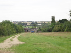
Soon the old route was rejoined and the trail descended down into the village of Ketton. I was becoming inured to picturesque villages now and I more or less ignored the stone houses that surrounded the main street. Instead I sat down on a bench to eat my sandwiches, only to find that they had been squashed and squeezed into a delightfully tasteful messy paste.
The trail passed two sides of the village before crossing a railway line to reach the smaller village of Geeston. Geeston and Ketton are so close together that they should really be one village, but the deep railway cutting appears to have kept them separate. Indeed, Geeston seemed to have a different, more rural character than its larger brethren.
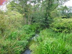
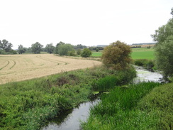
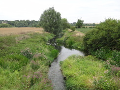
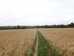
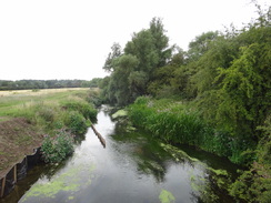
Unfortunately Geeston marked the start of more road walking as the trail headed down to Collyweston Bridge over the River Welland, which at this point is little more than a stream. The road obviously floods frequently as there was a raised concrete walkway alongside it, now sadly overgrown and impassable. Just after the bridge the trail left the road and climbed up a hill and I could not help but stop occasionally to look back at the expensive views. The quarries were clearly visible, as were the spires of several churches.
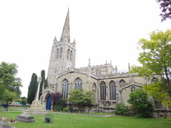
A rough track called Ketton Drift evolved into a firmer track and finally a surfaced road as it led me into Easton on the Hill. The pub in the village was open, but I ignored this and strode on past an exquisite war memorial and down to the church. What should have been a quiet, contemplative location was somewhat spoilt by a combine harvester that was being prepared for its work, a noisy but necessary intrusion.
Sadly this was the end of the rural parts of today's walk. The noise of the combine was replaced by the roar of traffic as the path descended to cross a railway line, a tributary of the Welland and then, finally, under the A1 in a long tunnel. Strangely the traffic noise vanished when under the tunnel and started again like a bang the moment I stepped outside of its confines. I have driven along the A1 many times and it is an utterly useful road, but it is a shame that its noise dominates the landscape so much.
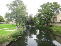
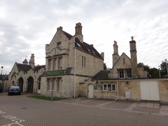
The last mile or so of the day crossed the floodplain of the Welland towards Stamford. It was a pleasant stroll as the spires and towers of the five churches in the towns grew above the surrounding houses. If Oakham is delightful then Stamford is perfectly sublime, with a centre of narrow streets surrounded by stone houses. It grew up around the lowest fording point of the Welland; this was used in Roman Times and a later bridge carried the Great North Road over the river. It became a prosperous Georgian town based around many coaching inns. Unfortunately the railway took a route further east and the town fell into a slumber as trains took over from the coaches. This was a saving grace as it meant that the town grew slowly.
After getting to the station I wasted twenty minutes in the large bookshop that dwells within the old station building before going to have a look around the town. I will never tire of strolling around Stamford, of examining its little nooks and crannies or just idling by the water's edge. Other people evidently felt the same, and the grassy areas by the river were filled with people even on such a cloudy day. It was the perfect place to end a good day's stroll.
 |
 |
|
Directions
The Hereward Way starts in Oakham at the level crossing immediately to the south of the railway station, at grid reference SK856089. Head east for a few yards from the level crossing and then turn left up Station Road before turning immediately right up Northgate Street. This heads eastwards through Oakham; it soon curves to the right and passes the Church Street short-stay car park on the left, where Northgate Street ends at a T-junction with Church Street. Turn right and then immediately left to head along a path between two brick walls with the church on the left, then turn left to follow another path between more walls, again keeping the church on the left.
The path emerges out into some parkland; turn half-right to take a surfaced path diagonally across the grass to reach a road junction with the B668 at SK862090. Head northeastwards along the B668 for about 250 yards passing a school on the right, before turning right into Woodland View. This soon curves to the left to take an east-southeasterly course. When the road ends continue on along a broad surfaced path; it crosses a road and after a quarter of a mile it reaches the A606 road. Carefully cross this and continue along a rough driveway on the other side.
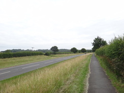
When Dog Kennel Cottage is reached turn right across an area of gravel parking. At the end of the gravel turn left through a gap in a hedge and then right to head to a stile beside a gate. Follow a footpath downhill keeping an intermittent hedgeline on the right. The path crosses a stile and continues descending downhill, passing a sewage farm on the right. The trail heads over a cattle grid to join a surfaced track that curves slightly to the left before reaching the A606 road at SK875085. Carefully cross the road and turn left to join the cycle path that parallels the road.
Continue eastwards along the cycle path beside the main road for 1.5 miles; at SK897093 the path starts to curves away to the right, with Rutland Water a short distance away to the right. The path heads in a rough southeasterly direction for about half a mile, passing through a couple of gates before the end of a minor road is reached at SK902087. Turn left to head eastwards up the road; at a mini roundabout after 250 yards turn right to continue along another cycle path that follows the access road that leads to a car park.
The cycle path is easy to follow as it descends into a small valley and climbs up the other side to reach the car park. Head through the car park and when it ends turn right to head through the northeasternmost car park. When this ends a path continues on, passing a gate to enter Barnsdale Wood with the reservoir a short distance away to the right. It eventually emerges from the trees and becomes a surfaced road, and a mile after the car park it goes through a gate to reach a car park in Whitwell at SK924082. Pass a cafe on the left to join a road in front of some car parks; turn left along the road and follow it as it immediately curves to the right, passing an activity centre on the left before ending at a T-junction with Bull Brig Lane.
Turn right down Bull Brig Lane for a few yards before turning left down a road that heads eastwards; as this road curves to the right continue on along a surfaced track that descends to meet the western bank of Whitwell Creek.
Follow the surfaced track as it turns left to head north, paralleling the shore on the right until a boat storage area is reached on the left, after which the path curves to the right across the head of the creek.
Continue along the cycle path in a rough eastwards direction for a mile as it parallels the northern side of the reservoir, passing through a couple of gates until the Sykes Lane car park is reached. Head through the car park; when it ends turn right down a surfaced path, heading through a gate to reach the northern end of Rutland Water dam. Do not turn right to follow the cycle path across the dam and instead turn half-right to descend down the grass to the southeast. Meet a fence guarding a copse and keep this on the left as you continue southeastwards.
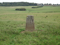
At the southern tip of the copse turn half-left by a concrete pillar to cross a stile and head eastwards across a field. The path soon crosses another stile to enter another copse; the path heads through this for a short distance until it descends some steps to reach a plank footbridge over a stream immediately in front of a stile. On the other side of the stile the path emerges from the copse; continue on for a short distance across a paddock to another stile in a fence. On the other side of the stile turn half-left to head northeastwards across another paddock. It crosses a stile beside a metal gate and heads along a narrow green path between houses to reach Nook Lane in Empingham. Continue straight on eastwards along this lane for a short distance until it reaches the A606 at SK948084.
Carefully cross the road to reach the pavement on the other side and then turn right to head southeastwards along the A606 for a couple of hundred yards; as the road curves to the right continue straight on along the pavement, passing a village sign on the right. When the pavement ends at a T-junction with Church Street turn left to pass the church on the right. Immediately after the church turn right up Crocket Lane. Follow this eastwards; it passes a grassy area on the left and then curves to the left.
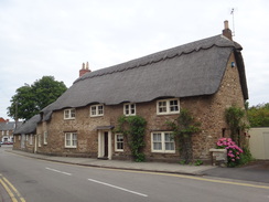
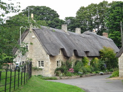
As it does so continue straight on along a narrow lane that runs between beautiful thatched stone cottages. When this ends continue straight on along a surfaced path with a hedge on the left; this emerges out through a metal clapper gate onto Willoughby Drive. Turn right along the road, keeping to the left of a little traffic island with trees on it. At its far (southern) end turn left to head east-northeastwards along a road. As this curves to the left take a road to the right and follow it eastwards for a short distance past houses on either side.
When the road ends turn left along a surfaced path for five yards; it curves to the right to cross a stile into a field. Head slightly south of east across the field, crossing a footbridge over a stream and heading across some scrubland to reach a stile that leads onto Mill Lane at SK957086. Turn right to head south along the road for a couple of hundred yards; cross a cattle grid and pass a house on the right as the road curves to the left. Turn right, keeping the house on the right, and continue southwestwards across a field for about twenty yards to reach a metal footbridge above a stream. On the other side of the footbridge turn left and then immediately right to head southwards up a slight hill with a hedge on the left. It eventually reaches the A606 road once more at SK957078.
Carefully cross the A606 and head straight on through a wooden pedestrian gate to join a bridleway. Keep a hedge on the left as you head along the field. When the field ends go through another pedestrian gate through a hedge and keep a copse on the left; when the copse ends continue on with a hedge on the left. Half a mile after the A606 the bridleway goes through another pedestrian gate to reach a road at SK956070. Turn left along the road for a couple of yards past the hedge and then turn left across a stile beside a double metal gate into another field. The path heads southeastwards across a field, skirting a hedge guarding the eastern end of a farm. It continues on towards the northeastern corner of New Wood, heading through a gap in the hedge to reach a stile.
Cross the stile at the corner of New Wood head straight on across the field. At the end of the next field cross a stile through the hedge and continue on with the hedge on the left. As the hedge curves to the left turn right to head straight on across about fifty yards of the field to reach a stile in a hedge. Cross this and a green track on the other side to reach another stile. Cross this to reach the western extremity of the quarry. The route from here to Ketton may change over time due to quarrying works; the route given here is correct as of 2011.
After crossing the second stile turn right and follow the path around the edge of the quarry. It soon curves to the left to head in an east-southeasterly direction. When this reaches a gate, take the left-hand fork which heads back to the edge of the quarry. Rather worryingly the path descends along a ridge left in the quarry to reach a large metal bridge over a haul road. On the other side a stony track slowly rises out of the quarry.
It reaches a summit and starts to descend, leaving the quarry well behind. At the bottom of the hill the track enters a farm and forks; take the right-hand fork and follow it for a short distance until it reaches the A6121 in Ketton.
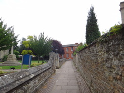
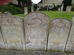
Turn right to follow the A6121 south for a fifth of a mile. As the road curves to the right, turn left past the village cross down Redmile's Lane. Shortly after this curves to the left, turn right down Chapel Lane which in turn ends at a T-junction with Church Road. Turn left along this road, passing the church on the left (the graveyard's boundary with the road being marked by a line of old gravestones) and cross the River Chater using a wooden footbridge alongside the road bridge.
Take the first road to the left, Aldgate, and almost immediately turn right past a gate to join a footpath that climbs up a slight slope. It crosses a driveway and continues on as an unsurfaced path between fences. It crosses an access road and heads on between hedges, climbing four steps on the way. After a sixth of a mile it reaches a footbridge that carries the footpath over a railway line.
Cross the bridge and continue southeastwards along the path; this end at a driveway that in turn ends after twenty yards at Geeston Road at SK986040. Turn right to head southwestwards along the road for a couple of hundred yards until it ends at a T-junction with another road. Continue straight on and follow this road as it curves to the left and descends, reaching Collyweston Bridge over the River Welland after nearly half a mile.
On the other side of the bridge the road curves to the right; ignore a track coming in from the left and immediately afterwards turn left through a hedge to enter a field. The path crosses a small plank footbridge and turns half-right to head east-northeastwards uphill diagonally across the field. Go through a couple of hedges as the path continues to climb. At the top of the hill cross another stile to join a track called Ketton Drift is reached at TF000040. Turn right and follow this track eastwards; initially it is a green lane, but after half a mile it becomes a public road called West Fields.
Continue along this as it crosses West Street and becomes High Street. Pass the Blue Bell Inn on the left, and at the war memorial turn left up Church Street. After a third of a mile it reaches the church on the left; continue along the track immediately beyond the church, passing a car park on the right, and then turn right through a gap in the wall to join another footpath. This soon heads across the access road to an extension of the car park to reach a stile.
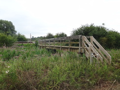
On the other side the footpath cuts diagonally across a field before reaching another stile through a hedge; it continues northeastwards across other fields, slowly heading downhill. Continue on northeastwards with a hedge on the left; the path takes a slightly more direct route than that shown on the map. It passes through a narrow patch of woodland to enter another field; at the northern end of this it descends into some boggy land to cross a stream on a footbridge. On the other side of the bridge it climbs up some wooden steps to reach a railway line.
Go through a gate and carefully cross the railway line to reach a gate on the other side. The path immediately crosses a footbridge over a stream and then descends down steps to enter a field. Head northeastwards across this for a short distance to reach the A1(T), and pass under this using a tunnel. Head northeastwards across the floodplain on the other side, with a stream of the river on the left; after a quarter of a mile a green footbridge (Broadeng Bridge) over the stream is reached.
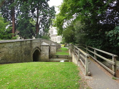
On the other side turn half-right to continue northeastwards across the floodplain. The path skirts a stream of the river on the right before passing through a hedge into a grassed area. Continue on across this to reach a track; turn right to head south for a few yards along a surfaced path to reach another footbridge (George Bridge) over the river at SK028068. Cross this and then head straight on uphill along Wothorpe Road; just before a bridge over a railway is reached, turn right down some steps and follow a narrow path with a railway line on the left until Stamford station is reached.
 |
 |
|
Distances
| From | To | Distance (m) | Ascent (ft) | Descent (ft) |
|---|---|---|---|---|
| Oakham station | Empingham | 7.7 | 325 | 489 |
| Empingham | Stamford station | 8.8 | 571 | 676 |
This makes a total distance of 16.5 miles, with 896 feet of ascent and 1165 feet of descent.
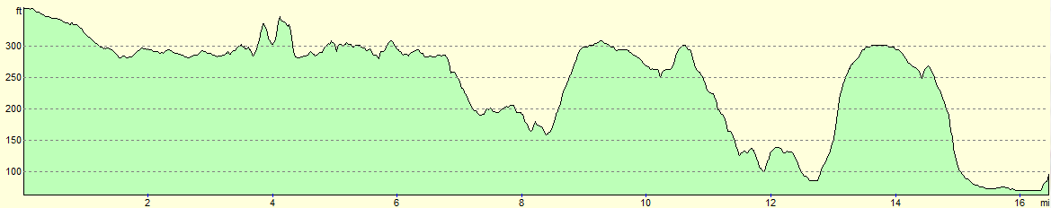
For more information on profiles, ascents and descents, see this page
Transport
Trains run regularly between Stamford and Oakham, on the line between Stansted and Birmingham. See the National Rail Enquiries website for more information.
 |
 |
|
 |
 |
|
 |
 |
|
 |
 |
|
 |
 |
|
 |
 |
|
 |
 |
|
 |
 |
|
 |
 |
|
 |
 |
|
 |
 |
|
 |
 |
|
 |
 |
|
 |
 |
|
 |
 |
|
 |
 |
|
 |
 |
|
 |
 |
|
 |
 |
|
 |
 |
|
 |
Disclaimer
Please note that I take no responsibility for anything that may happen when following these directions. If you intend to follow this route, then please use the relevant maps and check the route out before you go out. As always when walking, use common sense and you should be fine.
If you find any information on any of these routes that is inaccurate, or you wish to add anything, then please email me.
All images on this site are © of the author. Any reproduction, retransmissions, or republication of all or part of any document found on this site is expressly prohibited, unless the author has explicitly granted its prior written consent to so reproduce, retransmit, or republish the material. All other rights reserved.
Although this site includes links providing convenient direct access to other Internet sites, I do not endorse, approve, certify or make warranties or representations as to the accuracy of the information on these sites.
And finally, enjoy your walking!
Nearby walks
| # | Title | Walk length (miles) |
|---|---|---|
| 56 | Peterborough to Stamford | 16.5 |
| 58 | Stamford to Oakham | 16.8 |
| 59 | Oakham to Melton Mowbray | 10.6 |
|
|

|