Walk #574: Dovehill Wood to Hunstanton
 |
 |
|
General Data
| Date Walked | 21/10/2003 |
| County | Norfolk |
| Start Location | Dovehill Wood |
| End Location | Hunstanton bus station |
| Start time | 07.25 |
| End time | 10.26 |
| Distance | 8.3 miles |
| Description | This was a short but nonetheless quite enjoyable walk following the Peddars Way to it's end in Hunstanton. |
| Pack | Today I carried my 70-litre Craghoppers rucksack holding full camping gear and my new Jack Wolfskin Gossamer tent. |
| Condition | I feel absolutely fine after this walk, and have no significant problems to report. My left shoulder ached at times, but this was not too bothersome. |
| Weather | There were some fairly heavy showers overnight, and one of these was just dying out when I decided to set off. The early morning air was quite cold, but as soon as I started walking the rain lifted and some short periods of sunshine broke through the cloud. These soon widened leaving a nice and sunny day, with none of the nasty gusting winds of yesterday afternoon. |
| OS map | Landranger number 132 (North West Norfolk, King's Lynn & Fakenham) |
 |
 |
|
 |
 |
|
Map of the walk
Maps courtesy of Google Maps. Route for indicative purposes only, and may have been plotted after the walk. Please let me have comments on what you think of this new format. For a detailed table of timings for this walk, please see the table file.
Notes
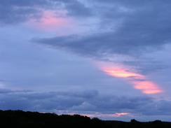
I woke up this morning to the sound of rain dropping heavily onto the tent a few inches away from my face. This was quite depressing, and the fact that I had a heavy headache at the front of my forehead hardly improved matters. Today was only going to be a nine-mile walk, and before I went to sleep last night I had been considering extending it in some way, but the weather and the headache definitely put me off the idea. Because of the rain I got my rucksack packed inside my tent, which was very difficult due to the cramped interior of the Gossamer - yet another point in favour of my old Westwind tent, which was positively palatial in comparison. It was still raining as I threw my rucksack out and started to dismantle the tent, my fingers going numb as I swept away the leaves that had fallen from the trees towering above the tent. I was greeted with a lovely sunrise outside the woodland, and as I started to walk thankfully the rain stopped for good.
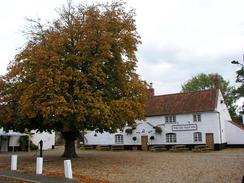
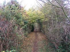
The walk passes to the east of the little village of Sedgeford and crosses the B1454 by the attractive-looking Magazine Cottage, which is believed to have been built as a gunpowder store in the seventeenth century. This makes me wonder exactly why so much gunpowder would be needed here - whilst it is not exactly in the middle of nowhere it does seem an odd place to find one. The nearby farm that I soon passed is called Magazine Farm, and I soon reached the trackbed of the old Wells-next-the-Sea to Heacham railway line, this part of which was used as a farm haul road. The walk was starting to warm me up and so I could take my balaclava off, and I soon started enjoying the walk more as I progressed on across fields and down into the village of Ringstead, the first village of any size that I had come across since Castle Acre, over sixteen miles before.
I found Ringstead to be an unexpectedly pretty village, and I slowed my pace and had a slow stroll through it. The pub in the village has the strange name of 'The Gin Trap Inn', a pub name that I cannot recall having seen before. As I climbed up the slight hill (there is not a single steep hill on the entire walk!) I passed the local post office and shop, which fortunately was open even though it was before nine. I nipped in and bought some chocolate, which was a fairly inadequate substitute for a proper breakfast. I chatted to the lady in the shop for a few minutes before heading out and passing the attractive church in the village, which almost seemed to glow in the early morning light.
As I climbed up out of the little village of Ringstead I saw my first glimpse of the sea since I finished my coastal walk in Edinburgh, and it was a sight that brought floods of tears to my eyes. This was a most unexpected reaction, and I was amazed that seeing an area of coast that I know well could have caused such an effect. It was not a depressing feeling, however, and was more positive than negative. I paused by an old windmill, now devoid of its sails, and looked down at the narrow band of sea that was visible, and it felt like I could feel every step of the 6,266 miles that I had walked over the previous year. The walk had a certain continuity to it; I knew that from here I had walked to (or from) virtually every point on the coast; a great and overwhelming achievement.
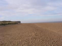
From the windmill the path descends slowly down towards the sea, crossing the A149 road and continuing on for about half a mile until a junction in the path is reached. Here the Norfolk Coast Path stretch of the Peddars Way and Norfolk Coast Path continues straight on, but I was making my way to Hunstanton, which involved turning to the left. On the previous occasions that I had been in this area I had walked from Holme next the Sea to Old Hunstanton along the beach, but today I was determined to stick to the National Trail for as long as possible. The trail passes a caravan park before running between a drainage channel and a golf course; I found this stretch of path to be exceedingly boring and the walk along the beach was far preferable.
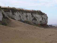
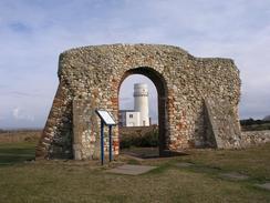
The sight of the red-striped rocks of the cliffs at Hunstanton proved welcoming, and a sign that this mini-trip was over. The cliffs look absolutely fantastic, comprising chalk, red sandstone and carstone in layers that have been likened to those of a cake. Certainly the red of the sandstone contrasts nicely with the chalk and the carstone, and the whole effect is very distinctive. I climbed up from the beach onto the top of the cliffs and passed the old lighthouse, now sadly without a light and looking distinctly odd because of it, and on to the ruins of St Edmund's Chapel, built in 1272 and of which only one small section of wall remains.
The last three quarters of a mile into the centre of Hunstanton were fairly boring, and I put myself into autopilot as I walked along the wide grassy strip between the road and the edge of the cliffs, occasionally waking myself up to look out to sea. I have been to Hunstanton a fair few times before, but suddenly found myself unable to find the bus station. Confusion reigned, and eventually I had to ask a passer-by who directed me down the next street. Was this temporary amnesia or just a symptom of tiredness after a long trip? I do not know, but I was relieved to see that a bus was due in a little over half an hour, and so I sank down onto a seat that proved impossible to sit on inside a shelter wand waited, the first leg of the two-hour journey back to Cambridge.
Directions
|
This walk follows the Peddars Way stretch of the Peddars Way and Norfolk Coast Path National Trail for its entirety. This path is very well waymarked and is navigationally easy, and directions and route maps are included in the excellent National Trail Guide 15, Peddars Way and Norfolk Coast Path by Bruce Robinson and published by Aurum Press, ISBN 1-85410-852-2. Because of this excellent guide I (as normal for National Trails) am not including directions for this walk, as the guidebook is unbeatable. Please click on the link to the right to access the Amazon page for the guidebook. |

|
Distances
| From | To | Distance (m) | Ascent (ft) | Descent (ft) |
|---|---|---|---|---|
| Dovehill Wood | Ringstead | 3.0 | 85 | 223 |
| Ringstead | Holme next the Sea | 2.5 | 72 | 118 |
| Holme next the Sea | Hunstanton bus station | 2.8 | 151 | 85 |
This makes a total distance of 8.3 miles, with 308 feet of ascent and 426 feet of descent.
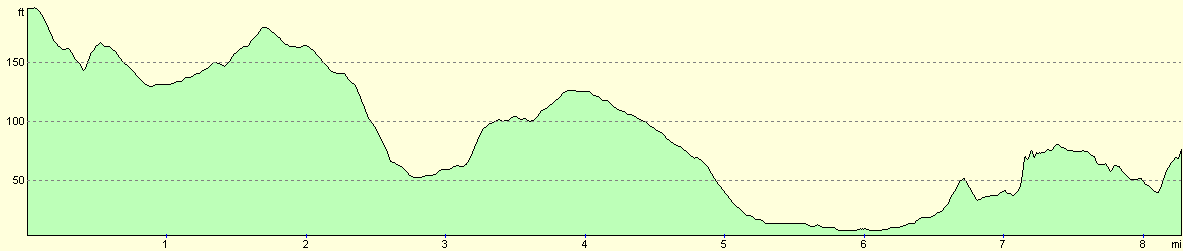
For more information on profiles, ascents and descents, see this page
Disclaimer
Please note that I take no responsibility for anything that may happen when following these directions. If you intend to follow this route, then please use the relevant maps and check the route out before you go out. As always when walking, use common sense and you should be fine.
If you find any information on any of these routes that is inaccurate, or you wish to add anything, then please email me.
All images on this site are © of the author. Any reproduction, retransmissions, or republication of all or part of any document found on this site is expressly prohibited, unless the author has explicitly granted its prior written consent to so reproduce, retransmit, or republish the material. All other rights reserved.
Although this site includes links providing convenient direct access to other Internet sites, I do not endorse, approve, certify or make warranties or representations as to the accuracy of the information on these sites.
And finally, enjoy your walking!
This walk was mentioned in the following routes:
| Peddars Way and Norfolk Coast Path |
Nearby walks
| # | Title | Walk length (miles) |
|---|---|---|
| 9 | Old Hunstanton and Holme | 4.0 |
| 133 | Hunstanton to Burnham Deepdale | 10.3 |
| 156 | Kings Lynn to Snettisham | 14.6 |
|
|

|