Walk #599: A circular walk from Westhumble to Surrey's highest point
 |
 |
|
General Data
| Date Walked | 28/03/2004 |
| County | Surrey |
| Start Location | Westhumble |
| End Location | Westhumble |
| Start time | 09.13 |
| End time | 16.48 |
| Distance | 20.0 miles |
| Description | This was an exceedingly enjoyable walk, taking in the highest point of Surrey at Leith Hill as well as the well-known viewpoint at Box Hill. |
| Pack | Today I carried my 30-litre Karrimor HotRock rucksack, which was filled with my waterproof leggings, water bottle, trainers and a couple of spare shirts, together with the usual assortment of odds and ends. It weighed slightly more than usual as I also had a bit of extra kit, such as my Psion, battery charger, cables and a tripod strapped to the side of the rucksack. |
| Condition | My legs ran out of energy towards the end of this walk, which is not surprising considering I did a long distance yesterday as well. My feet also ached towards the end, although fortunately no blisters formed. The worst thing was my right kneecap, which seized up on the last ascent of the day and, once I had freed it off, remained sore for the last few miles. I also had a little chaffing, so I think that it is time to retire my leggings for the season as they cause the irritation when it gets too hot. |
| Weather | The forecast was for good weather, so I was disappointed when I saw cloudy skies above me as I drove around the M25. The cloud did not deliver any rain and there was very little rain, so all in all it could have been much worse. |
| OS map | Landranger number 187 (Dorking, Reigate & Crawley area) |
 |
Map of the walk
Maps courtesy of Google Maps. Route for indicative purposes only, and may have been plotted after the walk. Please let me have comments on what you think of this new format. For a detailed table of timings for this walk, please see the table file.
Notes
Whilst studying maps last week and planning my walks for this weekend, I realised that I had only ever done one walk in Surrey, and that was only a couple of miles into the northern edge of the county. I therefore decided that one of the weekend's walks would be to Leith Hill, the highest point in Surrey (and indeed the highest point in the southeast of England), and I therefore found myself driving around the M25 to get to Dorking, where I intended to start the walk. Unfortunately when I got to Dorking station I found that the car park was filled with people going to a car boot sale, so I decided to drive a couple of miles south to Westhumble and Boxhill station. Once I got there I was annoyed to find that the direct trains from Boxhill to Horsham (where I had intended to walks to) did not run on Sundays, so I settled on doing a circular walk instead. A quick study of the map showed a very nice walk, taking on not only Leith Hill but also Box Hill, another local beauty spot.
After chatting to a couple of other walkers I set off on the walk, passing a very attractive flint archway before continuing along a narrow and winding road. I soon left this and dived off downhill between garden fences, some blown over by the winds of last weekend, before eventually reaching the North Downs Way. This stretch of the National Trail runs along a broad track, and is exceptionally easy to follow as it slowly climb uphill onto the North Downs escarpment. I had intended to continue along the track past Denbies to the road, but locked gates barred the way so I had to turn back and follow the North Downs Way past the imposing church on Ranmore Common to the road. A quick yomp along the road and I joined the Greensand Way, which started with a steep descent down to the valley floor.
I soon reached the A25 to the east of Westcott, and instead of following the Greensand Way, which skirts to the north of the village, I went along the road as I wanted too visit a shop to get something to eat - I had left my provisions in a bag on the passenger seat of the car! A newsagent shop gave me the opportunity to buy a few chocolate bars and a packet of crisps, before heading off towards Westcott Church. I soon joined a bridleway that took me past The Rookery, where there was a lovely house, beside which was a mine-waterfall at the outfall of a small lake. The scene was beautiful, and steeled me for the ascent ahead.
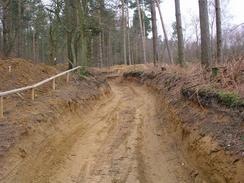
The track uphill seemed to go on forever, and was heavily rutted by the wheels of a near-endless stream of cyclists who passed me as I toiled onwards. At one point I was very surprised to see a trig point half-hidden in the hedge to my left, and after a little examination of the map I realised that I was on the wrong track; the one that I should have been ascending was further down the valley to my right. Even once I got home and studied the map I could not see where I went wrong. To get myself back on the proper path I descended a steep path that led down the hillside through the trees; it was steep enough when walking it, so I was quite surprised to see that the path was rutted with tyre tracks - I could hardly imagine cycling down it!
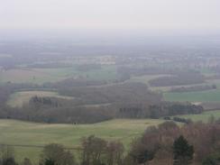
Eventually I reached a little col and turned right for the final short stretch of the ascent to the top of Leith Hill, the highest point of not only Surrey but also the highest in the entire southeast of England. The hill is dominated by the stone Leith Hill Tower, built in 1776 by Richard Hull of Leith Hill Place. Allegedly it was built so that the hill that it sits on could be classified as being 1,000 feet high, although that seems like a rather silly reason to build a tower to me! The tower is now owned by the National Trust and is open to the public, so I decided to climb the tower and visit the very top of Surrey. I paid the one-pound fee to a lady in the refreshment both built into the base of the tower, and started up the narrow and dark spiral staircase to the top. The views from the top were superb, with much of the south of England visible. The day was hazy, but apparently on a real clear day you can see the Thames to the north and the sea to the south. I spent a few minutes having a look around before yet more people came up and I headed down to ease the crowding on the balcony.
With some regret I left the tower and started heading down the slope to the little col between the hills, which by now was filled up with a group of cyclists. I had to study the map a little to find the correct route, which was uphill along a track. As I headed along this track there were occasional good views through gaps in the trees, and every bench I passed beside these gaps was filled with people admiring the view. After nearly getting run over by a motorcyclists roaring downhill I was nearly run over again by a group of five cyclists, which left me slightly annoyed. The track eventually ended in the village of Coldharbour, and the sight of the pretty Plough Inn proved to be an irresistible lure. The pub was quite busy, and it took me the best part of ten minutes to get served, but eventually I received a nice pint of Master Brew.
I left the pub in slightly higher spirits (both physically and mentally) than when I had entered, and started the climb uphill along a road. Once I reached a track that led off to the right I started following it through the trees, but after a couple of hundred yards it became obvious that it was heading in too much of a northerly direction. I fond a little path that led downhill to the right, and I followed this to rejoin the narrower, proper path. When I reached a junction in the paths I suddenly saw a trig point symbol on the map, and so I decided to try and find it. This meant a short diversion off my route, but I decided that this was worth it to be able to see yet another trig.
The trig point as quite hard to find in the forest, but after a little consultation of the map I found a muddy path through the trees that led off the track and to the trig. I took a few photographs and found myself wondering how the heck anyone could survey through such thick trees (obviously they had grown up since the trig point was constructed), and started to head off downhill along another track. Eventually the gradient slackened, and after crossing the A24 road I found myself on Holmwood Common. It took me a couple of minutes to find the right track across the common, but once I was on it it was easy to follow as it headed dead-straight northwestwards through the sparse trees. The track ended at a road junction, and this marked the start of three miles of road walking.
As I approached the village of Brockham I could see the escarpment of the North Downs slowly grow large, and seemingly steeper. The village itself was quite nice, with an interesting brick bridge over the river, adjacent to which was an attractive wooden arch bridge for pedestrians. It seemed like a good spot to rest and watch the water flow underneath, but I was well aware that the day was getting on and that I still had one big hill to climb. I soon reached the A25 road and crossed it to join a muddy path that headed uphill.
Initially this was not too steep, but after it had crossed over a railway line it started to enter some woodland and get steeper. I was soon puffing away and it was obvious that I was quite fatigued, as my legs were not necessarily responding to their commands. A couple of strategic breaks for photographs later I reached the point where the path met the North Downs Way, and I was dismayed to see a set of steep leading uphill to the left. After allowing myself a breather for a few seconds I headed up the steps, but had only done two or three of them before I felt a sharp pain in my right kneecap when I put weight on it. I tried to bend it ready for the next step, but I found that it would not respond. After rubbing it for a few minutes I finally managed to bend it, and gingerly made it to the top of the hill.
I spent a few minutes rubbing the kneecap as the pain slowly subsided, and I started to make my way along the North Downs Way. To make matters worse the path went through a wooded area and was quite muddy, whenever my right foot slipped slightly my knee would give a squeak of pain. I was severely annoyed to find a place where some muddy and worn steps led downhill, and I had to take these carefully as my knee complained at each and very one.
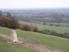
Eventually I reached a car park next to a restaurant, and I found that the path followed the side of the road. As the path was muddy I decided to walk along the road, which was not too busy and was definitely easier on my knee. The trig point near the top of Box Hill was directly below a viewing point, and I stopped for a couple of minutes whilst I took photos of the trig point and the substantial views southwards over Dorking. Half the world and their dogs seemed to be out on the hill, and I resisted the temptation of having an ice cream and hobbled away from the crowds.
The National Trust visitors centre was very busy, and I decided that instead of following the road down the hill I would take a bridleway. A few yards down this I was surprised to find a large military blockhouse in the trees, one of a chain of such blockhouses along the North Downs escarpment built in 1899 to protect London from invasion. Apparently this is the best preserved of them all, although the public are not allowed in as bats live in the underground ammunition chambers. I love coming across old military architecture, and as I stood beside the brickwork I tried to imagine it in use and without the trees that have grown up around it.
A gentle path downhill soon became quite steep as I passed a few children trying to fly kites, and it soon became exceedingly steep. I took great care as I headed downhill as I tried to protect my right knee from to much jarring, and I was very relieved when I reached the roundabout at the bottom of the slope. I crossed a bridge over the River Mole and, once on the other side, saw a very unusual sight in a field to my left - Highland cows in Surrey! Sam loved these beasts, so I spent a few minutes taking photographs of them, during which time the nearest one obstinately refused to look up and remained grazing. Having got a few good shots I headed through an underpass and walked the short distance through Westhumble to the railway station, where I was exceedingly relieved to find my car waiting for me.
Directions
This walk starts off at the car park outside Boxhill and Westhumble railway station. Leave the car park and turn left to head uphill for a short distance towards an attractive flint archway. Do not go through the arch but follow the road as it curves to the left to head in a more westerly junction. Pass the junction with Pilgrims Way and then turn left along a footpath that heads southwards between garden fences. The path crosses Adlers Lane and continue on to reach a wide broad track that carries the North Downs Way. Turn to the right and follow the North Downs Way as it slowly climb uphill, skirting Ashcombe Wood before levelling off. After a while the North Downs Way diverts to the right off the track, heading north for a couple of hundred metres to reach a track that leads to Denbies Farm. Turn left along this track for a few yards until it meets Common Road, and then continue straight on along this road. The road passes a beautiful church on the left before ending at a T-junction with Ranmore Road.
Turn left along Ranmore Road and follow it as it heads downhill to the east for a few hundred metres before taking a public footpath that plunges steeply downhill to the right, heading southwestwards through woodland. Once it emerges from the woodland the gradient levels out and the path continues along the valley floor, crossing the Dorking to Guildford railway line on a level crossing before continuing on southwards across fields. The path crosses Pipp Brook before joining a track that climbs up a light hill before reaching the A25 road. Once at the A25 turn right and started walking westwards up the hill into the village of Westcott. Pass the post office and then, shortly after The Cricketers pub, turn left up Logmore Lane that heads past Westcott Church. When Logmore Lane turns to the left after a short distance turn right along a little track that heads westwards past Westcott Heath; when this track curves sharply back on itself to the right continue straight on along a footpath that ends at the junction of the A25 and Rookery Drive.
At the road junction turn left and follow Rookery Drive as it heads southwestwards; the road crosses Pipp Brook by the outfall from a lake, and shortly after this turn left along a rough track that starts to climb uphill to the south. The track soon diverts uphill to the right to head steeply through Sylvanus Wood and meet the broad Wolvens Lane. Turn to the left and follow this lane as it heads southeastwards, passing a trig point and then entering another area of woodland. A few hundred metres into this woodland turn right along a small path that plunges steeply downhill to the west, eventually reaching Tilling Brook before ending at a road near Home Farm. Instead of following the surfaced road turn left to follow a track called Whiteberry Road as it heads southwards, slowly climbing uphill before reaching a col between two hills. At this col turn right and climb steeply uphill for a couple of hundred metres to reach the tower at the top of Leith Hill, which is the highest point not only of Surrey but also the whole of the southeast of England.
From the tower descend back downhill to the col and then head straight on along a broad track that heads northeastwards for a mile, initially on the level but eventually descending steeply to meet Coldharbour Road opposite the Plough Inn in Coldharbour. Turn left and follow the road as it starts to climb uphill to the northeast; continue on past the junction with Anstie Lane on the right and head uphill until a track crosses the road from left to right. Turn right along this track, but after a few yards turn right to join an obvious path that heads just slightly north of eastwards through the trees. When this path meets a track join it, and follow the track as it heads northeastwards and finally northwards through Redlands Wood until a junction with three or four other tracks is met. The trig point in Redlands Wood is about fifty yards away to the left; if you do not wish to visit the trig point then turn sharp right along a track that heads downhill to the southeast. When this track meets a bridleway at the bottom of the hill turn left and follow this bridleway eastwards until it meets the A24 road in South Holmwood.
Cross the A25 and once on the other side walk along a broad track that heads northeastwards across Holmwood Common for about a mile before it ends at a car park beside a triangular junction of Blackbrook Road and Red Lane. Head straight on along Red Lane, which heads eastwards, crossing a bridge over a railway line before a road junction is met on the left with Roothill Lane. At this junction turn left and follow Roothill Lane as it heads northwards. Near a farm the lane becomes Bushberry Lane and then Old School Lane, but continue straight on along it until it eventually ends at a T-junction in the village of Brockham. At the junction turn to the left and follow Brockham Lane as it heads northwards, crossing a wooden footbridge over the River Mole before ending at a T-junction with the A25 road. Cross the road and immediately on the other side take a track that heads northwards, crossing a bridge over a railway line before becoming a path called White Road that heads steeply uphill through some woodland.
Before the top of the hill is reached some steps lead off to the left; these steps mark rejoining the North Downs Way. Turn left and climb up these steps, and once at the top continue along the North Downs Way as it heads westwards. Near a car park and restaurant the path meets the Zig Zag Road, which it follows westwards to Saloman's Memorial and the trig point at the top of Box Hill. Here leave the North Downs Way and follow Zig Zag Road as it curves to the right. Just after it passes the National Trust visitor's centre on the left turn left down a path that heads past the disused Box Hill fort before curving to the right to head northwards. When the path forks take the left-hand fork, which continued northwards for a short distance before turning to the left and plunging very steeply downhill to meet Old London Road by the Burford Bridge Hotel. Turn left for a few yards until a roundabout with the A24 is reached; turn left for a few yards to a bridge over the River Mole. Cross the bridge and once on the other side pas under the A24 using a subway. This emerges out onto the western side of the A24 by Westhumble Street; follow this road westwards past the Stepping Stones pub back to Westhumble and Boxhill station, where this walk ends.
Distances
| From | To | Distance (m) | Ascent (ft) | Descent (ft) |
|---|---|---|---|---|
| Westhumble | Westcott | 4.4 | 665 | 509 |
| Westcott | Leith Hill Tower | 4.2 | 960 | 322 |
| Leith Hill Tower | Brockham | 7.0 | 305 | 1122 |
| Brockham | Westhumble | 3.3 | 659 | 636 |
This makes a total distance of 18.9 miles, with 2589 feet of ascent and 2589 feet of descent.
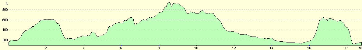
For more information on profiles, ascents and descents, see this page
Disclaimer
Please note that I take no responsibility for anything that may happen when following these directions. If you intend to follow this route, then please use the relevant maps and check the route out before you go out. As always when walking, use common sense and you should be fine.
If you find any information on any of these routes that is inaccurate, or you wish to add anything, then please email me.
All images on this site are © of the author. Any reproduction, retransmissions, or republication of all or part of any document found on this site is expressly prohibited, unless the author has explicitly granted its prior written consent to so reproduce, retransmit, or republish the material. All other rights reserved.
Although this site includes links providing convenient direct access to other Internet sites, I do not endorse, approve, certify or make warranties or representations as to the accuracy of the information on these sites.
And finally, enjoy your walking!
Nearby walks
| # | Title | Walk length (miles) |
|---|---|---|
| 676 | Farnham to Gomshall | 20.7 |
| 677 | Gomshall to Merstham | 17.4 |
| 678 | Merstham to Otford | 23.2 |
|
|

|