Walk #640: A circular walk from Edale to Lose Hill and Kinder Scout
 |
 |
|
General Data
| Date Walked | 29/12/2004 |
| County | Derbyshire |
| Start Location | Edale |
| End Location | Edale |
| Start time | 08.50 |
| End time | 14.04 |
| Distance | 12.4 miles |
| Description | This was a superb little walk, taking in part of the Castleton ridge walk and the eastern side of Kinder Scout. |
| Pack | Today I carried my 30-litre Karrimor HotRock rucksack, which was filled with three litres of water, a spare fleece, waterproofs and various electronic gadgets. |
| Condition | I had a little gip from my right knee on the last descent of this walk, which is an injury I received on Monday's walk. This was not bad, and aside from that I had no other problems, and could easily have walked further. |
| Weather | The forecast for today was for rain, and as we drive up to Edale there were ominous grey clouds over the hills. Fortunately when we got to Edale there were some sunny patches in the sky, and the clouds lifted somewhat by the time we reached Hollins Cross. This remained the pattern for the rest of the day, and it only worsened by the time we reached Grindslow Knoll, when the clouds descended and it started to spit with rain. This was not too heavy, and as it was far milder than it had been recently we remained relatively dry and in good spirits. |
| OS map | Outdoor Leisure number 1 (The Peak District - Dark Peak Area) |
 |
 |
|
 |
 |
|
Map of the walk
Maps courtesy of Google Maps. Route for indicative purposes only, and may have been plotted after the walk. Please let me have comments on what you think of this new format. For a detailed table of timings for this walk, please see the table file.
 |
Notes
I have a friend, Mike, visiting today, and we decided to go for a walk in the Peak, as we had last year when he visited. Last night we planned a walk based on Edale, and so early this morning we set off on the drive up to the village. It was a good journey, and when we arrived in the large car park at Edale we were slightly surprised to find only two other cars there. It did not take us long to buy a ticket (three pounds for all the day), get our rucksacks on and start walking. A short stretch of road walking took us eastwards, and we soon found ourselves on the first footpath of the day, initially heading solely uphill towards Peter Barn. The gradient became steeper as it headed past the farm at Hollins, but we soon found ourselves at the viewpoint marker at Hollins Cross, the first climb of the day completed.
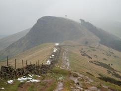
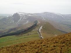
It was a surprisingly mild day, particularly after the cold weather of the last week, and when we reached the viewpoint Mike took off his fleece as he was so warm. The next stretch of walk is part of probably my favourite walk in the country, the long ridge walk from Mam Tor eastwards towards Lose Hill. Although we were only doing the eastern half of this route it was still an exhilarating stroll, with the steep climb up Back Tor having been tamed by stones having been put down. We made good time to the summit of Lose Hill and I was relieved to see the sun come out - the forecast had been for rain, and it looked as though that was the last thing the sky gods were going to throw at us.
The descent down southeastwards from the summit of Lose Hill to Townhead Bridge is a walk that I have never done before, and I found the going quite slippy after the snow of the last week had thawed out. I had left my walking poles in Cambridge, and I therefore took the descent quite slowly, unlike the three fell runners who came striding past us. On the descent we also encountered the first walkers of the day, as the ridge walk had been unusually devoid of walkers aside from ourselves - on a nice summer's day the ridge walk is more like a motorway than a path. Eventually we reached a track that led down to the Edale to Hope road - in nice weather this would have taken us less time, but in the slippy conditions we had to slow down.
At Townhead Bridge we re-crossed the River Noe, before taking a good track that led uphill to Fullwood Stile Farm, before taking another that headed northwards. The going was very easy, and although the track was flooded in places we made good time uphill along this track, which follows the course of an old Roman Road. The track approached some woodland and we had to skirt around some very boggy areas before eventually reaching Hope Cross, an ancient cross marking the crossing points of two tracks on this high, windswept moorland. At this point the three fell runners passed us once again, having obviously taken a longer route.
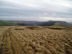
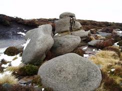
Shortly after Hope Cross we left the track and started climbing along an easy to follow path up Crookstone Hill, and we soon found ourselves climbing a short, steep section to reach the Kinder Plateau at its easternmost point. I was surprised to reach the top, as I associate climbing Kinder with steep and tiring climbs, but this approach proved to be by far the easiest and most gentle approach to the plateau. I had not been to this eastern side of Kinder for years, and I enjoyed exploring an area that I was not that familiar with. Once on the plateau we studied the map and decided on going around the northern edge of the plateau for a while, before cutting across to the Madwoman's Stones. The path was easy to follow as we headed past Crookstone Knoll, but we soon realised that the path was contouring too far down the slope, so we cut uphill for a couple of hundred yards to reach the proper path and then, instead of joining it, cut across to the fascinatingly named Madwoman's Stones'.
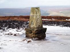
We did not stop to explore these rock outcrops, and instead started heading across to the trig pillar that was visible on the skyline to the west. Although it was only about a kilometre away we covered a greater distance than this, as we had to negotiate many drainage channels, many of which were covered in melting snow. Progress seemed slow as we climbed up and down through these groughs, and it was quite a relief when we finally reached the pillar, with muddy legs from the wet and boggy peat. Unfortunately the pillar was surrounded by a large expanse of water that had frozen, but as Mike discovered when he attempted to cross it the ice was melting, and he sunk in to the water and deep, oozy peat underneath. I made my way across to the pillar from a slightly firmer direction, and took some photographs of it before getting back to firmer ground.
We were making far better time than we were expecting, and in good spirits we walked the short distance southwestwards to the path that runs along the southern edge of the Kinder Plateau. The ground was firmer on this section and we did not have to make too many diversions before reaching the path immediately to the southeast of the path that leads up Golden Clough. I was surprised to find a wheeled trailer on the path - it had obviously been flow up by helicopter for workmen on the moors, and it made for quite an incongruous sight, sitting amongst the heather. Once we were on the path Mike started to make better progress than me, as I was being cautious on the slippy path that in places was covered in slushy snow and ice.
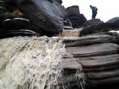
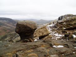
The southern edge of Kinder was quite busy with people compared to the centre of the plateau, and many people were walking along the edges in the same direction as us. The wind-sculpted rock formations on the edges of Kinder are fascinating, and as I stopped to take photographs of these I dropped further behind Mike. In attempting to keep up I started to live up to my reputation as being a mud devil, and I was soon finding patches of deep, boggy mud off the path that other people were missing. We had the options of descending down Grindsbrook Clough, but this is not my favourite route off Kinder and the stream was flowing strongly, which would have made the initial steep section more than a little wet and interesting.
As we had plenty of time Mike decided to walk on the short distance to Grindslow Knoll, and start the descent from there. The walk to the Knoll was easy, and just as we arrived the clouds started to gather and the rain began to fall lightly. This did not bother us as we only had a short distance to go downhill back to Edale, and indeed we were quite elated that we had escaped the cloud and rain on the plateau. I found the first part of the descent to be quite slippy and I took my time as we started to go down, and consequently Mike was a couple of hundred yards ahead of me by the time that the gradient slackened. Even though the path was not as steep I still found the going slippy, and on a couple of occasions my feet slipped on icy stones.
Despite my slow pace we soon reached fields that despite being flatter was muddy, and I found myself jogging down the path until it reached the Pennine Way. From her eon the going was easy for the last few hundred yards towards the Nag's Head in Edale and the end of the Pennine Way. I used the opportunity to wash my boots in the stream, and the last half-mile down the road to the car park in Edale was an enjoyable stroll. Once at the car we changed out of most of our wet and muddy clothes, before walking to the Edale café for a delicious and welcome bacon and egg sandwich, washed down with a large mug of hot chocolate. It had been a very good walk, and although if I had been on my own I would probably have walked further (for instance by taking in Win Hill) it had a superb day out, made even more so by the unexpectedly nice weather. When we got back home I was amazed to find out that we had climbed over 3,000 feet during the course of this walk - I did not feel as though the walk had been that strenuous.
Directions
This walk starts off at the car park near the railway station in Edale. Leave the car park and turn left to walk eastwards along the road. After a few hundred yards turn right to head south along a footpath that descends a short distance to cross the River Noe on a bridge. The path then starts climbing, skirting Peter Barn and passing the farm at Hollins before becoming steeper as it climbs up to the southeast, to reach the viewpoint at Hollins Cross. Once at the viewpoint turn left and start following the obvious path eastwards, following Barker Bank before climbing up steep stone steps to the top of Back Tor. A short descent follows, before the path slowly starts climbing to reach the summit of Lose Hill.
From Lose Hill take a path that heads off downhill to the southeast; initially it is paved with stones but it then becomes grassy as it reaches a junction with another path. Her take the left-hand path, and follow it as it heads downhill, slowly curing to the east across Laybrook Pasture. The path meets the end of a rough track, which passes Losehill End before reaching the farm at Townhead, where the track becomes paved. Continue on along this track downhill to the southeast until it meets a road immediately to the south of Townhead Bridge.
Once at the road turn left and follow it for the few yards to Townhead Bridge over the River Noe. When the road curves sharply to the left on the other side of the bridge continue straight on, following a paved track that leads uphill to the northeast, crossing a bridge of the Hope Valley railway line before reaching Fullwood Stile Farm. At the farm turn left, to start following a track that heads slowly uphill to the north. After a little over a kilometre it takes a slightly more northwesterly course, before meeting another track that leads from the top of Win Hill. The track is easy to follow, if a little boggy, as it heads northwestwards, eventually reaching a prominent stone post at Hope Cross. Continue on along the track past the cross, and when the track enters access land turn left to follow a distinct path that leads westwards across moorland.
This path passes to the north of Crookstone Barn, and is easy to follow as it climbs Crookstone Hill and starts to twist around before climbing more steeply to reach the path that runs along the top of the Kinder Plateau at it's easternmost point. At a junction of the paths turn right and follow it as it heads northeastwards for a few hundred yards before curving sharply to the left above Crookstone Knoll. When the Madwoman's Stones become visible to the south at about SK137882 leave the path and head southwestwards the couple of hundred yards to the stones. When at the stones head slightly south of west along the plateau, aiming for the trig pillar at SK129878, which, if it is clear, will be visible on the skyline. There is no path and the going is difficult as there are many little groughs that need to be crossed.
Once at the trig point head southwestwards, aiming to reach the path that runs along the southern edge of the plateau near Golden Clough. The going is easier with only a couple of groughs to be crossed. Once the path is reached turn right and start following the path as it winds westwards along the plateau. The path is relatively easy to follow and well worn, as it passes many fascinating rock formations, weathered by the wind. Eventually the path curves southwards to reach the top of Grindsbrook Clough; here take a path that heads southeastwards along the western edge of the clough, slowly climbing up to reach Grindslow Knoll, at 601 metres nearly the highest point of the day's walk.
From Grindslow Knoll take a rough path that heads steeply downhill to the southeast. The path is easy to follow once the gradient becomes shallower; although the gradient soon steepens again as it curves to head southwards to enter enclosed land and cross a field to meet the Pennine Way. At the Way turn left and follow it as it heads eastwards for a few hundred yards until it meets the road by the Nag's Head Inn in Edale. At the road turn right and start following it downhill to the south for half a mile; once the road passes under a railway bridge turn left to pass the toilets and reach the car park in Edale, where this walk ends.
Distances
| From | To | Distance (m) | Ascent (ft) | Descent (ft) |
|---|---|---|---|---|
| Edale car park | Townhead Bridge | 3.5 | 924 | 1152 |
| Townhead Bridge | Crookstone Knoll | 3.6 | 1268 | 131 |
| Crookstone Knoll | Edale car park | 5.3 | 872 | 1781 |
This makes a total distance of 12.4 miles, with 3068 feet of ascent and 3064 feet of descent.
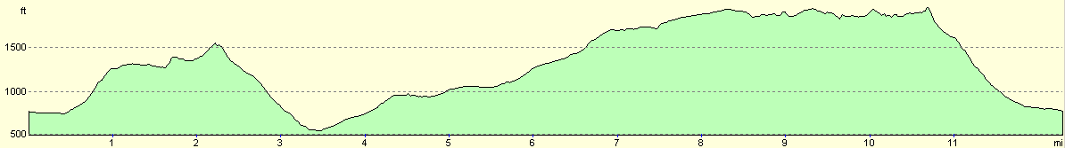
For more information on profiles, ascents and descents, see this page
Disclaimer
Please note that I take no responsibility for anything that may happen when following these directions. If you intend to follow this route, then please use the relevant maps and check the route out before you go out. As always when walking, use common sense and you should be fine.
If you find any information on any of these routes that is inaccurate, or you wish to add anything, then please email me.
All images on this site are © of the author. Any reproduction, retransmissions, or republication of all or part of any document found on this site is expressly prohibited, unless the author has explicitly granted its prior written consent to so reproduce, retransmit, or republish the material. All other rights reserved.
Although this site includes links providing convenient direct access to other Internet sites, I do not endorse, approve, certify or make warranties or representations as to the accuracy of the information on these sites.
And finally, enjoy your walking!
Nearby walks
| # | Title | Walk length (miles) |
|---|---|---|
| 13 | Edale and Kinder Scout | 11.0 |
| 19 | Castleton circular via Lose Hill and Mam Tor | 7.7 |
| 23 | The Limestone Way from Pomeroy to Castleton | 14.0 |
|
|

|