Walk #670: Kingussie to Aviemore
 |
 |
|
General Data
| Date Walked | 12/05/2005 |
| County | Highlands |
| Start Location | Kingussie |
| End Location | Aviemore |
| Start time | 09.15 |
| End time | 15.18 |
| Distance | 15.1 miles |
| Description | This was a fairly uninteresting walk, mainly following roads to Aviemore. |
| Pack | Today I carried my 70-litre Craghoppers WildPlaces rucksack, filled with full camping gear. |
| Condition | I feel absolutely fine after this walk. During my rest stop I pulled off my socks to discover that I have a blister on my right foot where the Compeed plaster has rolled up. Once I removed the remains of the Compeed the foot felt better and the discomfort more or less went away. |
| Weather | Today's weather was quite warm and sunny, with little cloud in the sky for much of the day. It was also quite a warm day, which meant that I had to slap suntan lotion on the back of my legs and neck. |
| OS map | Landranger number 35 (Kingussie & Monadhliath Mountains) and Landranger number 36 (Grantown & Aviemore, Cairngorm Mountains) |
 |
 |
|
 |
 |
|
Map of the walk
Maps courtesy of Google Maps. Route for indicative purposes only, and may have been plotted after the walk. Please let me have comments on what you think of this new format. For a detailed table of timings for this walk, please see the table file.
Notes
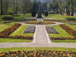
Today was going to be another short day, and so instead of setting off early I hung around in the bunkhouse for a while, writing postcards and typing up some notes on my Psion 5. I was in no hurry to set off, and whilst the others went to a nearby cafe for a cooked breakfast (I decided to forego on this as I cold not face one) I sat around, read, typed and wrote. Eventually it got to a quarter past nine, and I shouldered my rucksack and headed out of the door. I took my time going through Kingussie; I stopped off at the post office to send the postcards (one was sent to Sam in Australia, and so I had to get the correct postage for it), and then nipped into the chemist shop next door to buy some suntan lotion. I slapped this on as I walked through the pleasant park towards the railway station, where I met a couple of other challengers. I chatted to them for a while, before heading off down the road.
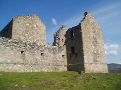
I soon reached Ruthven Barracks, and I could not help but take my rucksack off and go to explore them. The barracks were started in 1719 and completed in 1721 in response to the 1715 Jacobite uprising, and designed to house 120 troops in two barrack blocks. It is built on the site of an earlier castle built in 1221, which shows that the strategic advantages of the site was recognised early on. In 1734 a stables block was built to house 28 horses. When the next Jacobite uprising occurred in 1745 200 troops attempted to capture the barracks, but a force of just 12 redcoats forced them off with the loss of one man. In February the next year the Jacobites succeeded in gaining control, and the barracks was destroyed in fire as they retreated on 17th April 1746. The barracks are apparently pretty much as the Jacobites left them, a vibrant set of ruins. See www.ipix-photos.co.uk/ruthven/hi-res/ for a 3D view of the barracks.
Eventually I pulled myself away from the ruins and headed back up the hill towards where a group of challengers were standing chatting. We then all walked off down the road together, and I chatted to a couple of challengers from Brechin, who were hoping to finish the challenge on Monday. It was a nice chat, and the next couple of miles seemed to fly by. We soon reached the beautiful Tromie Bridge, which the River Tromie passes under through in a maelstrom of white water. Once I reached the bridge I started to feel slightly depressed and indecisive; most of the challengers were leaving the road here to head down Glen Feshie and then onto Braemar; if I took the same route it would cut a day off the walk, and I was still concerned about whether I could reach Montrose on Tuesday. On the other hand, when I had planned my route Aviemore and the Lairig Ghru had been on my must-do list of places to visit. I stood around by the bridge for a few minutes thinking, making a pillock of myself by making one decision and then another. Eventually I decided to follow my original route, and I said goodbye to the others and headed off down the road.
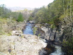
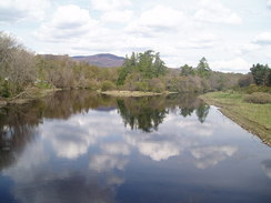
I felt quite low as I strolled along for several reasons. Firstly I was annoyed at my indecision, which I thought had been extremely silly of me. Secondly I knew that my route to Aviemore was mainly along roads and was hardly going to be a classic stroll, particularly as my feet were aching already. Thirdly, once I left the bridge I scoffed down a pack of Bombay Mix, and I used up much of my water trying to get rid of the resultant burning in my mouth and throat. A note to myself: Bombay mix may be nice, but do not eat it on a long walk... The road passed through the small hamlet of Insh before heading on, passing to the south of Loch Insh. Again I had to make a decision here; I could continue along the road to Aviemore via Feshiebridge, or follow another road to Kincraig. Eventually I decided on the latter, and I followed the road as it headed northwards, passing a water sports centre at Loch Insh before reaching a bridge over the River Spey, where I got some picturesque views up and down along the river.
There was a hotel marked on the map in Kincraig, and I had visions of stopping off at it to have a quick pint and rest my feet. Before I reached the hotel, however, I came across Kincraig Stores. This small oasis of a shop had a bench and table outside it, so I wearily dumped my rucksack off and went inside. I bought myself an ice cream and some chocolate, before going outside to savour them in the sun. I also used the opportunity to take my boots and socks off, and I then discovered why my right foot was aching so much - the Compeed plaster that I had put on a few days ago had rolled up into a ball and was putting pressure on the old blister, causing a new one to form. I removed the remains of the plaster and decided not to put another one on until I reached Aviemore as my feet were not dry. Eventually I put my socks and boots on and pulled myself away from the seat to continue the walk.
The next stretch of walk was the only stretch of off-road walking that I did today, as I followed the Badenoch Way eastwards as it headed above the northern bank of the River Spey. The Badenoch Way heads from Kingussie towards Aviemore and would have been an ideal off-road route for me to follow today, but unfortunately it is not marked on my current OS maps, and would therefore have been very hard to follow. The path made for a nice stroll and there were some superb views down over the river below, and as my right foot had stopped aching so much I felt considerably more at ease. The path ended too soon at a local road, and I used an adjacent road bridge to cross the railway line before plunging back into some woodland. It was not obvious where the Badenoch Way went from here, so instead I just followed a broad track northeastwards through the woodland. Once the track reached the end of the woodland it ended, but a gate let me through into the farmland beyond at Moor of Alvie. Nearby I could see construction work, and as I approached along a rough track I discovered that new tracks and chalets were being built, an extension to the existing holiday park further east. I passed workmen and stopped to chat to a lady outside a chalet; it turns out that her husband is on the challenge and they had spent the night in the chalet.
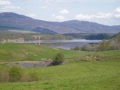
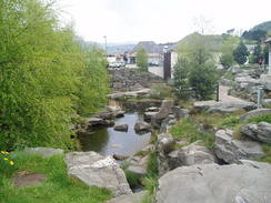
The Badenoch Way ends at the entrance to the caravan park, and I was forces to walk northeastwards along the main road. This was fairly busy and there were many curves in it, so I took my time, By Loch Alvie there was a memorial to three people who had died in the loch, and I found myself making a silent prayer for them as I walked. It was hardly an enjoyable stroll, and I was relieved when the road became straighter as it approached Aviemore. I had not booked any accommodation in Aviemore and so I was planning to make my way towards the Tourist Information Centre, but immediately beyond the B970 road junction I came across a sign for the Scottish YHA in the town. I nipped up the driveway more in hope than expectation but was relieved to find that they had a spare bed for the night, despite being full for the next two nights due to a walking festival that was taking place in the town. Thankful at having found a bed for the night, I dropped my rucksack off in my room and had a long, hot soak in a shower.
All of this put me in a much better mood, and I spent half an hour typing up notes in the common room of the hostel before heading out into the town. I made my way to the post office to post off a couple of maps that I had finished with, and to visit the tourist information office to book a B&B in Braemar. Having done this I walked back through the town, taking my time to visit the plethora of walking shops in the town as I walked. It was a pleasant time, and after a period back in the hostel In went out to get a meal. The main hotel in the town had been recommended to me, and when I went in I saw several other challengers, who invited me to join them, I had a very enjoyable evening, and this was topped up by being told that in Clova (which I would reach in three days) there was a bunkhouse. As I walked back to the hostel I made a couple of phone calls, got the number of the Clova Hotel and booked a bed for Sunday night.
Staying at the youth hostel will give me several advantages; firstly it will allow me to get an early start in the morning (I could be on the road for seven instead of nine if I were to stay at a B&B), and secondly it is much cheaper. As well as allowing me to have an early start, it is conveniently close to the road junction that I will have to take to get to the start of the Lairig Ghru Pass. I am very much looking forward to tomorrow's walk, and I can only hope that I have good weather for the climb up through the pass. It is also pleasing to think that I am well over halfway through this trip, and have suffered no significant problems so far. I have little doubt that I shall reach Montrose next Tuesday, although I have some long days ahead of me.
Directions
This walk starts off in the centre of Kingussie. Walk westwards along the A86 until the junction with the B970 is reached; turn left and follow the B970 as it heads southwards, passing the railway station and then crossing the River Spey before passing under the A9. At Ruthven the road curves to the left, and passes the obvious Ruthven Barracks before continuing on. Stay on the B970 for about six and a half miles until a road junction is reached on the left; turn left and follow the road as it had northwards along the eastern bank of Loch Insh and over the river Spey. Continue along he road until Kincraig Stores are nearly reached, and then turn right to go down a sort residential road. When this road ends continue on to the left along a path that climbs uphill before skirting high above the northern bank of the river.
When the path meets a road turn left and cross the railway line on a bridge. Immediately on the other side turn right and start following another path that leads through a forested area; there are many tracks but the one that I followed heads in a rough northeasterly direction before emerging out of the forest into an area of holiday chalets. New roads and chalets were being built as I passed, so the directions could well change in future. Head northeastwards through the site soon joining surfaced track that end up joining the B9152 road. Turn right and carefully follow the B9152 road as it heads northeastwards, passing Alvie and Loch Alvie before eventually heading up into Aviemore. Pass the junction with the B970 on the right and the Scottish Youth Hostel Association building is on the left, just before the old Tourist Information Office is reached (the Tourist Information Office has been moved into the centre of the town, but the signs for the old one are still extant).
Distances
| From | To | Distance (m) | Ascent (ft) | Descent (ft) |
|---|---|---|---|---|
| Kingussie | Kincraig | 9.0 | 535 | 571 |
| Kincraig | Aviemore | 6.1 | 509 | 495 |
This makes a total distance of 15.1 miles, with 1044 feet of ascent and 1066 feet of descent.
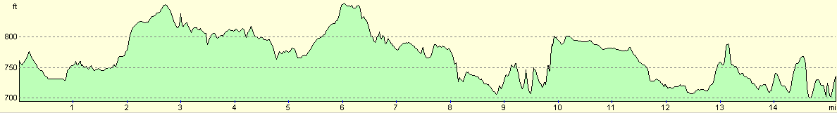
For more information on profiles, ascents and descents, see this page
Accommodation
I spent the night at the Scottish Youth Hotel Association hostel in Aviemore, which cost me twelve pounds for the night. This is a large youth hostel but is well equipped. There is also an apparently good bunkhouse almost directly opposite.
Disclaimer
Please note that I take no responsibility for anything that may happen when following these directions. If you intend to follow this route, then please use the relevant maps and check the route out before you go out. As always when walking, use common sense and you should be fine.
If you find any information on any of these routes that is inaccurate, or you wish to add anything, then please email me.
All images on this site are © of the author. Any reproduction, retransmissions, or republication of all or part of any document found on this site is expressly prohibited, unless the author has explicitly granted its prior written consent to so reproduce, retransmit, or republish the material. All other rights reserved.
Although this site includes links providing convenient direct access to other Internet sites, I do not endorse, approve, certify or make warranties or representations as to the accuracy of the information on these sites.
And finally, enjoy your walking!
This walk was mentioned in the following routes:
| The Great Outdoors Challenge 2005 |
Nearby walks
| # | Title | Walk length (miles) |
|---|---|---|
| 669 | Laggan to Kingussie | 13.9 |
| 671 | Aviemore to Derry Lodge | 18.0 |
|
|

|