Walk #683: Shepherdswell to Folkestone
 |
 |
|
General Data
| Date Walked | 16/07/2005 |
| County | Kent |
| Start Location | Shepherds Well station |
| End Location | Folkestone central station |
| Start time | 09.35 |
| End time | 17.32 |
| Distance | 18.5 miles |
| Description | This was a varied walk; the first half being a nice, gentle stroll towards Dover, and the second half being an exhilarating and fascinating walk along the top of the White Cliffs of Dover. |
| Pack | Today I carried my 30-litre Karrimor Hotrock rucksack, containing my waterproofs, a few odds and ends such as spare batteries, my Psion 5 and two litres of water. |
| Condition | I feel absolutely fine after this walk, and have no problems to report. |
| Weather | Today was quite a warm day, although there was a certain amount of cloud to stop me from overheating too much. There was not much wind and absolutely no sign of any wind. |
| OS map | Landranger number 179 (Canterbury & East Kent, Dover & Margate) |
 |
 |
|
 |
 |
|
Map of the walk
Maps courtesy of Google Maps. Route for indicative purposes only, and may have been plotted after the walk. Please let me have comments on what you think of this new format. For a detailed table of timings for this walk, please see the table file.
 |
 |
|
 |
 |
|
Notes
Another weekend dawned, and it was obvious to me which walks I would be doing - the last two days of the North Downs Way. It took me longer than I was expecting to drive down from Cambridge to Kent, and it was well past nine before I parked my car in Shepherdswell Station car park. I quickly pulled together my kit, and started walking back up the road to where I had left the North Downs Way the previous Sunday, near the church. From the map it was obvious that the walk was going to be a walk of two halves - an uncomplex walk to Dover, followed by an exhilarating Clifton walk along the coast to Folkestone. I had done the cliff top walk before on my coastal walk, and was very much looking forward to doing it again.
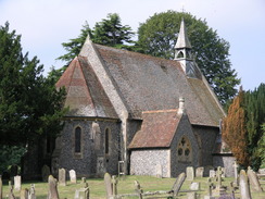
Initially the Way took me eastwards across farmland towards the spectacular 18th Century Waldershare manor house. This was very attractive, but unfortunately the sun was in the wrong position to get some good shots of it. Scaffolding clad the rear of the building, and it seems to me as if it has been converted into housing, and if do, they have done a very good job of it. The Way headed on eastwards, passing a nice flint church (now closed, but kept in good order by a charity), and crossing the A256 road on a bridge. Another short stroll took me on to Ashley, where the eastwards progression of the day ended, and the path turned to take a more southerly course.
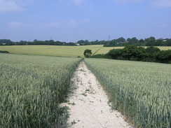
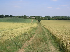
Whereas the stretch from Shepherdswell to Ashley had been mostly along footpaths, the stretch south down to Dover turned out to be a long plod along tracks and bridleways. The scenery was nice but nothing spectacular, and I found myself making good progress through Pineham and on down towards the A2 crossing. Here the guidebook had the Way crossing the road on the level, but when I reached the northern side of the road I could see that the path had been diverted off to the left. On the map it was obvious that it was going to take me towards the road overbridge to the south of Guston, and so I walked along a path that paralleled the road. Unfortunately the path was overgrown, and as I was wearing shorts I found my legs were exposed to all the grasses and thistles that lay at the sides of the narrow corridor between the road and the fields.
By the time that I reached the road bridge I had walked for over half a kilometre, and although the going on the other side was less overgrown and consequently easier, I found myself ruing the diversion just to get over the road. From the A2 the going started to become less urban; to my left some large transmitter masts grew out of the hillside in the distance, and I soon found myself descending into the northern outskirts of Dover. On the descent I was annoyed that I could not see the sea - I would just have to wait for that. The route through to the centre of Dover was well way marked and I found it easy to follow the busy roads through the town. The Way passed the bus station and entered Pencester Gardens, which was bustling and nearly full with people attending a Saturday market. It was quite a pleasant sight; above the gardens loomed Dover Castle on it's rocky hill, and music blared out of speakers attached to the bandstand. I walked slowly through the market looking at some of the stalls, and successfully managed to resist the temptation to buy a hotdog from one of the burger vans.
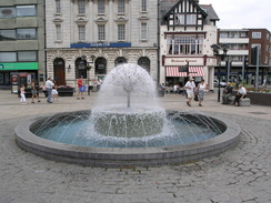
A few minutes later I found myself in the market square, which is the official end of the North Downs Way and is quite a pleasant place, with a circular fountain setting off some pretty buildings, I had not thought much of Dover when I had walked through it before on my coastal walk (during which I had followed roads past the port), and so it was a surprise to find that the actual centre of the town was so nice. I allowed myself a quick moment of self-satisfaction at having walked the North Downs Way all the way from Farnham, and I nipped into a handy pub a few metres away from the Market Square for a couple of pints to celebrate. I knew that I had not finished the entire Way as I still had the southern part of the Canterbury loop to walk, but I had at least walk from it's start to end point (relatively few people do the entire Canterbury-Dover loop, and most choose either the southern or northern part of the loop to reach Dover).
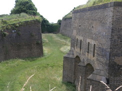
The pints refreshed me, and I set off with renewed vigour along the Way as it started to head westwards. I passed through a fairly uninspiring section of the town before starting a steep climb up to the Western Heights. Every so often I would turn around to have a look at the superb views over the town, with Dover Castle and the port dominating the view. Eventually the path levelled out and reached the Drop Redoubt, a pentagon-shaped fort dug into the hillsides, shaped so that fire can be laid in every direction without the need for flanking defences. This was built between 1804 and 1808 as part of the North Lines fortifications, and was only abandoned in the 1950's when Coast Defence finished. I marvelled at the deep trenches held back by high stone walls, and as usual when I look at fortifications I ended up wondering how you would have attacked it at the time that it was built. Images of soldiers firing guns from the caponiers dominated my thoughts as I walked along, and only ended when I left the Drop Redoubt behind me.
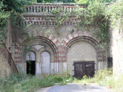
That was not the end of the Western Heights fortifications, however. After the fort the Way dropped down to a road, and a short distance away to the right there were two high arches set into the hillside. One of the doors to these tunnels was open, and when I looked inside I was rather disappointed to only see a room lacking floorboards. The road continued on, passing the flint remains of an old church, which, according to the nearby notice board, was a Knights Templar church, and would have been a place that the knights prayed when coming back from the continent. It was a dominating position, and nearby there was another military installation on the heights, which was now part of an immigration removals centre. From here the views southwestwards towards Shakespeare Cliff were good, and as I dropped down to cross the A20 via an underpass I found myself feeling very, very good.
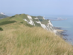
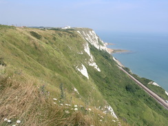
At the underpass I rejoined the route that I had walked on my coastal walk, and the climb up to the top of Shakespeare Cliff felt like an old friend. I paused every so often to have a loon east along the beach towards Dover, the sun glinting magnificently on the small swell out to sea. I was disappointed that I could not make out the coast of France, but the skies were just too hazy. I walked on along the cliffs, passing a series of concrete bunkers that were obviously built to try and prevent any invasion of Dover. Three friendly horses were grazing the path, and I fed a couple of them some long, luscious grass that they could not reach on he other side of the fence. They then followed me for a couple of hundred yards, almost as if they expected me to keep on feeding them. Soon Samphire Hoe came into view at the base of the cliffs; this is a large area of land reclaimed from the sea, the material to do so being from the Channel Tunnel, which heads out to France beneath the cliffs.
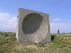
It really was a magnificent walk along the top of the cliffs, and I soon found myself wishing that I could walk around the coast once again, a feeling that I occasionally get, particularly when visiting spectacular stretches of coast. After a while I reached something that I had been looking forward to all day - a large concrete structure standing proud near the edge of the cliff. This structure is a sound mirror, built between the wars as a way of detecting enemy aircraft coming in. The parabolic surface of the concrete concentrated sounds onto a sound horn, and this gave observers a few seconds precious warning of incoming aircraft, and even had direction-finding capabilities. There were several such mirrors nearby along the cliffs, standing monuments to a scheme that got abandoned before the Second World War because of ever-increasing aircraft speeds and the rise of radar systems. I sat down with my back to the base of the mirror, and spent ten minutes looking out to sea. Curiously enough, the next Friday was the first episode of the BBC series 'Coast', and the presenter Nicholas Crane stood in exactly the same spot that I was sitting!
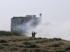
As much as I wanted to keep sitting there I knew that I had to get a move on, so I got up and continued walking. A little further along the cliffs there was another bunker complex, and ahead I could see grey smoke rising from fields to the left of the track. I walked on, and soon came across a police car and fire engine standing on the track. Firemen were in the field to the left trying to extinguish a large grass fire, and as the smoke was blowing straight across the track I decided against going through immediately. I took a few photos of the firemen working, when a sudden breeze caused the hedge about five yards from me to catch fire. I moved back as some firemen rushed forwards to tackle the new outbreak. Smoke and dust flew everywhere, and I waited for a gap in the smoke before walking through to the other side. As I emerged from the smoke another fire engine turned up, and I pushed my back against the hedge as it carefully went past me down the narrow track.
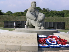
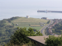
As I continued westwards along the cliff tops I passed a large caravan park before reaching a little cafe, where I bought an ice cream, which I promptly dropped onto the ground before I had finished it. There then came the Battle of Britain memorial at Capel-le-Ferne, consisting of some earthworks and a statue of a man in flying jacket looking out to sea. I went to look at some polished stone slabs naming air crews who had flown in the Battle, and found it quite a poignant experience - at a time when London is suffering bombings, it is important to remember those who gave their lives to give us the freedoms that we now have. I walked around for a few minutes, before heading on along the cliffs. The path crossed the B2011 road near a pub, and I continued on to the trig pillar on Dover Hill, from where I got a superb view down over Folkestone. Below me I could clearly see Martello Tower number three, its whitewashed walls standing out clearly against the blue sea and the green grass on which it stands.
A few hundred yards further on the path met a road, and here I left the North Downs Way for the day; turning left to head along a steep path that led down Creteway Down. At the bottom it was a matter of walking along roads towards Folkestone station; I pushed myself to walk fast despite weary feet, as I only had a few minutes spare before the bus was due. I arrived at Folkestone Central station with about ten minutes to spare, and I waited for the bus (which due to engineering works is replacing trains to Dover Priory) I looked back on an exhilarating day's walk. After changing at Dover Priory station I arrived back at Shepherds Well station, and I drove to the campsite that I had booked at Satmar, near Capel-le-Ferne. It did not take me long to get my tent up, and after I had done so I realised that I had left my knife and fork at home. This mean that I could not really cook, and so I drove down into Folkestone, where I found a superb chip shop. It was a beautifully warm evening, and I lay on a blanket outside my tent, ravenously devouring the fish and chips whilst chatting to Sencan on the phone. It had been a superbly memorable day, and one that I may well walk again sometime.
 |
 |
|
Directions
The walk is also covered in detail in the North Downs Way National Trail Guide, by Neil Curtis and Jim Walker, ISBN 1 85410 853 0, published by Aurum Press Ltd.
There are two exceptions to this at either end of the day. At the start of the walk, leave Shepherds Well station and take a footpath that leads uphill alongside the railway line. When this ends at a road, turn right and follow a road for a few yards as it heads over the railway line on a bridge. Once a crossroads is reached on the other side, turn left and follow a road as it heads uphill. Once the village green is reached at the top of the hill turn left along another road for a few yards until the North Downs Way is reached. P> the other exception is at the end of the walk above Folkestone. Just before a large transmission mast is reached at the top of Creteway Down at TR230381, leave the road by turning left and take a footpath that heads steeply downhill. The path ends at a road in a residential estate; head straight across down another road and then take some steps that leads down onto the A260. Cross the A260) via the traffic lights and then turn right for a few yards to large roundabout with the A259(T). Turn left and follow the A259(T) Black Bull road as it heads southwards towards the centre of Folkestone. When the A259(T) turns sharply to the right follow it as it curves around, eventually heading southwestwards as it climbs up a little hill with a park on the right. When a roundabout is reached continue straight on and cross the road; Folkestone Central railway station is up a road to the right.
Distances
| From | To | Distance (m) | Ascent (ft) | Descent (ft) |
|---|---|---|---|---|
| Shepherds Well station | Shepherdswell | 0.5 | 108 | 0 |
| Shepherdswell | Ashley | 3.2 | 157 | 295 |
| Ashley | Dover | 5.7 | 381 | 623 |
| Dover | Aycliff | 1.5 | 371 | 328 |
| Aycliff | Creteway Down | 5.9 | 1699 | 1240 |
| Creteway Down | Folkestone Central station | 1.7 | 72 | 469 |
This makes a total distance of 18.5 miles, with 2788 feet of ascent and 2955 feet of descent.
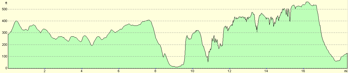
For more information on profiles, ascents and descents, see this page
Transport
It is possible to get from Folkestone Central to Shepherds Well stations by train; this involves a change of trains at Dover Priory station. At the time of writing trains between Folkestone Central and Dover Priory have been replaced by buses whilst the coastal railway line is upgraded; these busses lave every fifteen minutes.
Accommodation
I spent the night camping at the Little Satmar Holiday Park, Winehouse Lane, Capel-le-Ferne, Folkestone, Kent CT18 7JF. Telephone (01303) 251188. This is a nice campsite with some good facilities, and cost me Ł10.00 for the night.
Disclaimer
Please note that I take no responsibility for anything that may happen when following these directions. If you intend to follow this route, then please use the relevant maps and check the route out before you go out. As always when walking, use common sense and you should be fine.
If you find any information on any of these routes that is inaccurate, or you wish to add anything, then please email me.
All images on this site are © of the author. Any reproduction, retransmissions, or republication of all or part of any document found on this site is expressly prohibited, unless the author has explicitly granted its prior written consent to so reproduce, retransmit, or republish the material. All other rights reserved.
Although this site includes links providing convenient direct access to other Internet sites, I do not endorse, approve, certify or make warranties or representations as to the accuracy of the information on these sites.
And finally, enjoy your walking!
This walk was mentioned in the following routes:
| The North Downs Way |
Nearby walks
| # | Title | Walk length (miles) |
|---|---|---|
| 292 | Ramsgate to St Margaret's at Cliffe | 17.7 |
| 293 | St Margaret's at Cliffe to Hythe | 17.1 |
| 294 | Hythe to Dungeness | 14.7 |
|
|

|