Walk #682: Chilham to Shepherdswell
 |
 |
|
General Data
| Date Walked | 10/07/2005 |
| County | Kent |
| Start Location | Chilham station |
| End Location | Shepherds Well station |
| Start time | 05.40 |
| End time | 12.25 |
| Distance | 19.7 miles |
| Description | This was a pleasant walk following the northern edge of the Canterbury Loop, the highlight of which was the stroll through the centre of Canterbury. |
| Pack | Today I carried my 30-litre Karrimor Hotrock rucksack, containing my waterproofs, a few odds and ends such as spare batteries, my Psion 5 and two litres of water. |
| Condition | Aside from a general tiredness I feel okay after this walk; the underside of my feet ache slightly, and my right shoulder was aching at times. Aside from this I had no problems, and could easily have walked further. |
| Weather | The morning started off murky with cloud and a little fog, but as the morning went on this slowly lifted leaving an absolutely scorching day - in one place on the south coast thirty degrees was reached. There was little breeze, but as I started my walk early I only got the very start of the heat. |
| OS map | Landranger number 179 (Canterbury & East Kent, Dover & Margate) |
 |
 |
|
 |
 |
|
Map of the walk
Maps courtesy of Google Maps. Route for indicative purposes only, and may have been plotted after the walk. Please let me have comments on what you think of this new format. For a detailed table of timings for this walk, please see the table file.
 |
 |
|
 |
 |
|
Notes
My idea of spending the night in the car, whilst good in theory, proved to be fundamentally flawed in practice. The first mistake was my choice of location; last weekend I had thought that Hollingbourne station, situated as it was nicely away from the village, would be a good place to park my car whilst I slept. Unfortunately I had noticed the streetlights overhead, and these cast a dreary orange glow through the windows. I managed to position the car and hang clothes up to block out the brightest lights, but as it went on past eleven I still could not get to sleep. The occasional train passing by did not help, and so by about midnight I moved my car to a little passing place about a third of the way down the access road, and eventually managed to get a fitful sleep.
Dawn broke shortly after four in the morning, and although the slowly rising lightness did not wake me, the continual chirping of birds overhead did. I tried to slumber on, but as usual with me once I am awake I am awake for good, and unable to get back to sleep. After ten fruitless minutes I put my shoes on, got out of the car, and walked around a bit, straightening my legs and trying to get myself awake. Once this was done, I got in my car and started the drive to Chilham station, where I had ended yesterday's walk. The drive was quite nice and the roads exceptionally quiet, although I took it fairly easily due to my tired state. I eventually pulled up at the station, and slowly got my kit packed, ready for what would be the earliest start of a walk ever for me.
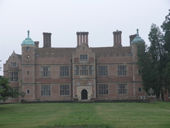
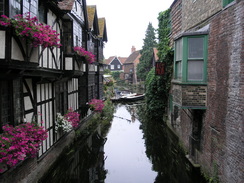
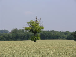
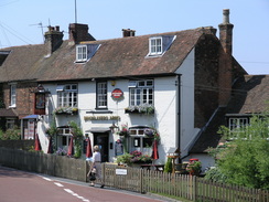
I left the car and started the mile walk back up to the centre of Chilham, and unsurprisingly I was totally on my own for this walk. Chilham is known as being the prettiest of all the Kent villages, and whilst the previous evening it had been bustling, this morning it was deserted, which allowed me to get some of the photographs that I had missed last night. Many of the buildings are extremely pretty, and behind some gates at what side of the square stood Chilham Castle, a brick building that looked little like a traditional castle. The forecast for the day had been for very hot weather, but there was little sign of it at this time - cloud was overhead, and the views were all hazy as I set off down the road that led to the next village of Old Wives Lees. On the way I passed an orchard on the left, the first of many Kent orchards that I would be passing today.
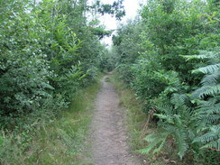
Old Wives Lees itself was not particularly notable, and I soon headed off along the road and path that led northeastwards. In a little valley I passes a field of hops, wires strung between poles being used to grow them on. It seemed to take me an age to reach the railway line near Dunning Shaw, and shortly afterwards I reached the village of Chartham Hatch. Again this was deserted, and a nice stretch of path took me through an orchard towards the A2(T) #, a pleasant walk in the early morning. The path crossed the A2(T) and then skirted it for a few hundred yards before turning to head northeastwards, soon climbing up the steep but short Golden Hill. This marked the entrance to suburban Canterbury, and what followed was a walk along roads northeastwards towards St Dustan's, which marked the northernmost point of the Canterbury loop of the North Downs Way. From here the path turned to head southeastwards, soon reaching the spectacular West Gate.
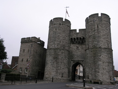
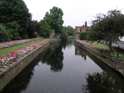
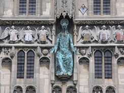
The West Gate is the only old gate remaining in the town, and it is a fairly spectacular entrance. It survived because until the last century it was used as the city prison, and now one half of the main road into the city goes underneath it (the other half goes around the side, between the gate and the adjoining church). From here I followed the main pedestrianised street through the city; the path was not marked but it was a simple matter to follow the streets through the city. It was still well before nine in the morning and I passed a man setting up a market stall, whom I chatted to for a few minutes before heading on towards the cathedral. I soon found the main entrance gateway, which was a very spectacular structure, with a large statue of Jesus dominating the entrance. Unfortunately the actual cathedral precinct was closed (I later found out that you have to pay to get in), and so I could not go in for a look around the outside of the building.
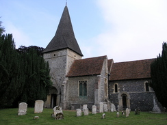
I walked on out of the city, nipping into a shop on the way to get an extra bottle of water on the way, and passed outside St Augustine's Abbey, which lies immediately outside the eastern city wall. Again the grounds of the abbey were not open, and you have to pay to get in - and unfortunately this is something that sticks in my mind about the city - you seemingly have to pay to see things. Canterbury cathedral is the only cathedral in the UK that I know of where you have to pay to even walk around the outside! I do not mind paying to go inside a cathedral, but to pay to enter the grounds is, in my opinion, wrong. This did not particularly upset me, though, and I soon reached the next target, St Martin's church, which is probably the oldest church still in regular use - some courses of the lower walls are even Roman in date, and it is older than the cathedral itself. A service was about to start so I did not go in, and contended myself with walking around the outside.
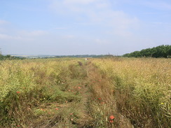
A fairly straightforward walk along tracks and roads took me to Patrixbourne, where after the church the Way left roads and headed uphill along a footpath, skirting towards the A2(T). It ran alongside the road for a while, the road being in a cutting to the right, before starting to angle away across Barham Downs. I passed a couple out walking on this stretch of path as it entered a long field with high crops in. Some of these came up to my shoulders and I ended up having to wade through long stretches of crops that obscured the path in places. It was hard going but also quite fun, and made what would probably have been a fairly boring stretch of path at least partially entertaining. This ended by the time that I reached Upper Digges Farm, and a more straightforward and easy path took me on towards the church at Womenswold.
By this stage I was aware that if I pushed I may be able to get the 12.30 train from Shepherd's Well, and so I started to increase my pace along the path as it skirted past Woolage Village and climbed up towards Three Barrows Down, one of the barrows being visible on the skyline to my right as I approached the top of the hill. I pushe3d on down to the railway line, and started yomping along the road immediately afterwards, alternating jogging and walking to save time. This made the underside of my feet ache, but also made me feel quite good - I enjoy pushing myself occasionally. The Way soon left the road and I yomped along a path that cut a corner between two roads before I came to a level crossing; in my guidebook this was marked as a mineral railway and I was therefore surprised to see a DMU train pulling away from the crossing - it turns out that the line is now the preserved East Kent Light railway, open to passenger services occasionally.
Another stretch of footpath followed, which led me south into the heart of Shepherd's Well. By this stage I had about fifteen minutes before the train was due, so I left the Way and started yomping down the hill towards the railway station. I reached this a few minutes before the train was due, and I sat down on a bench in the shelter to wait for it, amazed that I had finished such a long walk by half past midday. I had to change trains in Canterbury, and I used the opportunity to walk around the city for the hour between my trains and explore a little, including a quick walk around some of the remaining stretches of city walls. Whereas the city had been almost deserted earlier in the morning it was now bustling with people, a dramatic difference that took some of the character of the place away. It had been a good walk, and one positive point of the early start was that I had missed the warmest part of a very hot day.
Directions
The walk is also covered in detail in the North Downs Way National Trail Guide, by Neil Curtis and Jim Walker, ISBN 1 85410 853 0, published by Aurum Press Ltd.
There are two exceptions to this at either end of the day. At the start of the walk, leave Chilham station and head up the station approach road until it ends at the A28 road. Turn left along the A28, and follow the road as it curves to the right. When Bagham road is reached on the right turn right and follow it as it heads up a slight hill to the west. At a road junction beside a pub turn right and follow another road westwards up a steeper hill until Chilham Church and the North downs Way is reached.
The other exception is at the end of the walk; when a road is reached in Shepherdswell near the church turn right and walk for a few yards to the village green, and then turn right down Church Hill, heading down a hill until a crossroads is reached. Turn right and follow the road for a few yards as it crosses over a railway line on a bridge, and then turn left along a footpath that leads down to Shepherds Well station.
Distances
| From | To | Distance (m) | Ascent (ft) | Descent (ft) |
|---|---|---|---|---|
| Chilham station | Chilham | 0.7 | 95 | 23 |
| Chilham | Canterbury | 7.6 | 814 | 909 |
| Canterbury | Patrixbourne | 3.5 | 210 | 180 |
| Patrixbourne | Shepherdswell | 7.4 | 719 | 384 |
| Shepherdswell | Shepherds Well station | 0.5 | 0 | 108 |
This makes a total distance of 19.7 miles, with 1838 feet of ascent and 1604 feet of descent.
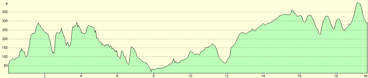
For more information on profiles, ascents and descents, see this page
Transport
There are regular railway services between Shepherds Well and Chilham railway stations. Unfortunately you need to change at Canterbury, a change that requires a fifteen-minute walk from Canterbury East to Canterbury West stations.
Disclaimer
Please note that I take no responsibility for anything that may happen when following these directions. If you intend to follow this route, then please use the relevant maps and check the route out before you go out. As always when walking, use common sense and you should be fine.
If you find any information on any of these routes that is inaccurate, or you wish to add anything, then please email me.
All images on this site are © of the author. Any reproduction, retransmissions, or republication of all or part of any document found on this site is expressly prohibited, unless the author has explicitly granted its prior written consent to so reproduce, retransmit, or republish the material. All other rights reserved.
Although this site includes links providing convenient direct access to other Internet sites, I do not endorse, approve, certify or make warranties or representations as to the accuracy of the information on these sites.
And finally, enjoy your walking!
This walk was mentioned in the following routes:
| The North Downs Way |
Nearby walks
| # | Title | Walk length (miles) |
|---|---|---|
| 179 | Sittingbourne to Faversham | 13.9 |
| 289 | Sittingbourne to Faversham | 16.3 |
| 290 | Faversham to Reculver | 17.8 |
|
|

|