Walk #711: South Downs Way: Cocking to Pulborough
 |
 |
|
General Data
| Date Walked | 30/01/2006 |
| County | West Sussex |
| Start Location | Cocking |
| End Location | Pulborough station |
| Start time | 08.52 |
| End time | 15.14 |
| Distance | 18.1 miles |
| Description | his was very much a walk of two parts; the first part a highly enjoyable stroll following the South Downs Way eastwards, which was followed by a lowland walk northwards across the floodplain of the River Arun. |
| Pack | Today I carried my 70-litre Craghoppers containing a light load of spare clothes, waterproofs, a couple of books and food. |
| Condition | I feel absolutely fine after this walk, and have had no significant problems. Neither of my knees gave me any trouble today. |
| Weather | The day was generally cloudy with occasional sunny periods; the chilly breeze of the last couple of days was last fierce, but still chilling when I was exposed to it. |
| OS map | Landranger number 197 (Chichester & The South Downs, Bognor Regis & Arundel) |
 |
 |
|
 |
 |
|
Map of the walk
Maps courtesy of Google Maps. Route for indicative purposes only, and may have been plotted after the walk. Please let me have comments on what you think of this new format. For a detailed table of timings for this walk, please see the table file.
 |
 |
|
 |
Notes
I awoke quite early this morning, very cold due to the fact that the heating in the bedroom had gone off in the evening. Shuddering from the chill I went into the bathroom, which fortunately had heating, and warmed myself up on the radiator before running back into bed, trying to make the thin white duvet cover me fully. There was still a couple of hours to wait before breakfast, and so I alternately watched breakfast news and read from my book, gently idling away the time until breakfast at 08.00. The breakfast was large and filling, and the landlord at least seemed more chatty than he had been the night before, when the football match on the television had taken virtually of his attention in the deserted bar.
The breakfast did not take long, and I reluctantly made my way up to my cold room, got changed into my walking gear, packed my rucksack and took everything downstairs ready to set off. I said goodbye and headed outside, and was surprised to find that it felt less cold than my room had been. I was tempted to nip into the post office to buy some chocolate for the day, but I still had several bags of nuts and raisins left, so I headed off along the road. The previous evening I had decided to take a different route out of Cocking to the one that I had descended down yesterday, mainly due to the mud on the route., I therefore walked towards the ominously-named Crypt Farm, heading under an old railway bridge and once at the farm heading steep uphill, pausing only to study a portal of the old railway tunnel that headed south under the downs.
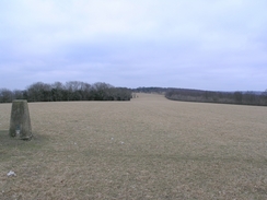
The track was a far easier walk then yesterday's descent had been, and I soon found myself at Hilltop Farm. I stopped to look back westwards towards Cocking Down, and then retraced my steps from yesterday to the A286. This was quite busy, and it took me a couple of minutes to safely cross, and I then started heading off, taking only a few minutes to reach Hillbarn Farm, where I had left the trail yesterday. At the farm there is a tap where walkers and horse riders can get water - a great touch, particularly when combined with the adjacent sign showing where the next taps were along the trail. The ascent up onto Heyshott Down was not too step and there was a good track underfoot, easing my progress. Trees soon encroached to my right, and patches of the woodland was being cleared as I walked past, giving me plenty of machinery to study as I walked. After a short distance I passed a deer shooting tower on the left, and, shortly afterwards, a trig pillar became visible on the same side. I left the path to visit this and notices some chalk graffiti on it - it looks as though someone has been visiting the pillar every New Years Eve for a few years, chalking the date on the northern face of the pillar on every visit.
The views from the pillar to the north were quite good, mainly due to the lack of foliage on the trees, and after studying these I headed back to the trail, and continued along it eastwards. A short distance further on I came across a series of Bronze Age burial mounds, apparently dating from about 1500 BC. These were scattered around on both sides of the track, and some of the rectangular mounds had tree trunks lying recumbrant around them; apparently these were placed to stop mountain bikers using the mounds as jumps, although I find it hard to imagine that anyone would use historic sites in such a way. There was little to see on these mounds and there were no interpretation boards, so I plodded on, the walk through the woodland being slightly boring. Parts of the woodland were being cleared to create a wildlife corridor between the downs, and further on I came across some beaters for a local shoot.
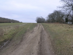
The track emerged from the trees, and soon started to descend from Littleton Down towards Littleton Farm and the A285 road. This was an easy descent, and as I plodded down the grass slope it was easy to see the track that I would be taking up the other side. The road proved easy to cross, but on the eastern side of the road I was immediately greeted by an area of thick, cloying mud, white from chalk. The ground had been churned up by vehicles, and pools of water lay in large pools. It proved relatively easy to get around these, and as soon as the path started to ascend the ground became firmer. As I walked I listened to Radio 5, who were interviewing a girl of ten who wanted to keep on playing mixed football after the age of eleven; something the Football Association do not allow. Amazed that the topic could occupy ten minutes of broadcasting time, I walked on as the gradient slackened as Burton Down was reached.
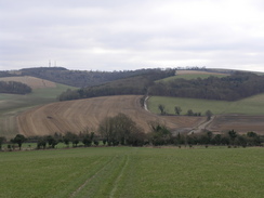
To the left were two large radio masts on Glatting Beacon, that I would continue to see for most of the day. I soon reached Stane Street, an old Roman Road that used to connect Chichester with London. It was quite an exposed location, and this situation got worse as the way left the road after a hundred yards and started climbing up towards the summit of Bignor Hill. The panoramic views more than made up for the wind chill and to the south I cold clearly see the coast and sunlight glinting off the sea. The track descended to some barns, and a very muddy, cloying track led uphill onto Bury Hill. I diverted off to visit the trig pillar in a field to the north, but was disappointed to find that the views were not as good as I was expecting due to an adjacent hedge.
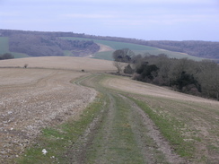
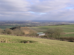
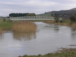
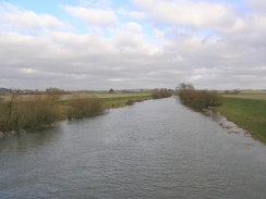
The way descended from Burty Hill to the A29, and then on downhill towards the valley and the River Arun. On the descent I got a superb view over the floodplain, and I stopped to take a panoramic photograph before heading on down to the footbridge over the river. The river is tidal (and indeed is as far as Pulborough where I ended the walk), and the water was flowing upstream, a sign of how low-lying the land is around here. Another short stretch of oath took me over the railway line on a bridge and to the B2139 road in Amberley, where I had planned to end the day's walk. Amberley station was only a few hundred yards to the south, but as it was still early I decided to leave the South Downs Way and walk on to the next station at Pulborough, which I estimated to be about four or five miles to the north.
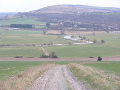
On the way into Amberley village I could see Ambeley Castle off to my left, a fourteenth century stone enclosure fortress, containing an older manor house. The castle is now used as a hotel, and a flag fluttered above the battlements. Amberley village was fairly pretty, and I was surprised to find a cottage being thatched, not in straw, but in reeds, something that I had never seen done before, and which I thought was unique to the Fens. A very muddy track led me on northwards across Amberley Wild Brooks, which is reclaimed marshland. I was following the Wey South Path, which was a long-distance path that I had never heard of before, and although the route was low-lying there was plenty to see amongst the reeds that lined the edges of the drainage ditches.
Fairly soon the path climbed slightly and joined a track, which winded around before joining the eastern bank of the River Arun to Greatham Bridge. This medieval bridge was a fascinating stone structure, with several arches and a modern iron bridge carrying the road over the river. Many of the arches were at different heights, giving the bridge a hump-backed look Once over the bridge the path followed the road before heading off to strike northwards along a path with an area of boggy land off to the right. This was marked on the map as being a disused canal, but it was hard to believe that the shallow watercourse, blocked by old, fallen trees, had ever carried boats. It turned out that the canal was the Hardham canal, which was built to cut a large loop out of the River Arun to speed traffic. The canal only operated for about fifty years, and the tunnel was blocked up after the railway lines that ran above it were built.
The path dropped me abruptly off at the A29, and instead of continuing along the Wey South Path I turned right and started following the road into Pulborough. It was a long walk but there was a pavement for the entire way, which allowed me to make good time safely despite the traffic on the busy road. I eventually reached the railway station and was glad to find that the ticket office was open; I purchased a ticket to Shelford that proved to be cheaper than I expected, and went over to the other platform to wait for the next train to London Victoria. I could look back on what had been an enjoyable three-day stroll, and I found myself really wanting to get on with the remainder of the South Downs Way soon.
Directions
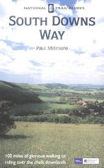
The walk is also covered in detail in the South Downs Way National Trail Guide, by Paul Millmore, ISBN 1 85410 966 9 published by Aurum Press Ltd.
The exceptions are at the beginning and end of the day. The walk starts off at the Blue Bell Inn in Cocking, which is near to the post office in the village. Walk south along the A286 for a hundred yards, and when a road leads off to the right follow nit as it heads southwestwards. The road passes under a single-arch railway bridge before reaching Crypt Farm. Just before the farm is reached, turn sharp left along a path that climbs up to the east before turning to the right to head south. The path becomes a track, which reaches the South Downs Way at Hilltop Farm. From here, it is simply a case of following the South Downs Way eastwards for twelve miles until the B2139 road is reached in Amberley.
Once the B2139 road is reached, turn left and follow it as it curves around to head northeastwards towards Amberley. When a footpath leads off to the left, follow it as it heads northwards for a hundred yards between fences, ending at a road in the village. Head straight on along another road, and when this curves to the right turn left along a track, joining the Wey South Path. The path heads northwards across Amberley Wild Brooks, and then ascends slightly to join a track that winds around before skirting the eastern bank of the River Arun to reach Greatham Bridge. Turn left and cross the bridge, and once on the other side continue along the road for about a hundred yards until a footpath leads off to the right, Join this footpath and follow it as it heads northeastwards for a kilometre, ending at the A29 road near Hardham Priory. Once at the A29 turn right and follow this road as it heads northeastwards into Pulborough, and when a crossroads with the A283 is reached turn left to walk westwards along the A283. After a couple of hundred yards a rail bridge over the road is reached; here turn right and walk up towards Pulborough station, where this walk ends.
Distances
| From | To | Distance (m) | Ascent (ft) | Descent (ft) |
|---|---|---|---|---|
| Blue Bell Inn, Cocking | Hill Barn farm | 1.1 | 233 | 30 |
| Hill Barn farm | A285 | 5.3 | 620 | 614 |
| A285 | B2139, Amberley | 6.7 | 692 | 1053 |
| B2139, Amberley | Pulborough station | 5.0 | 151 | 157 |
This makes a total distance of 18.1 miles, with 1696 feet of ascent and 1854 feet of descent.
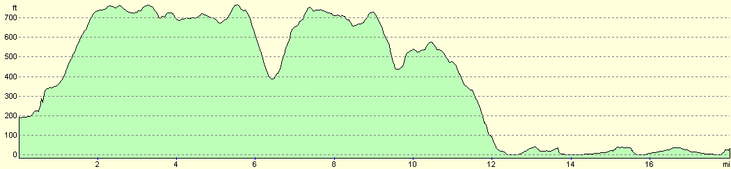
For more information on profiles, ascents and descents, see this page
Disclaimer
Please note that I take no responsibility for anything that may happen when following these directions. If you intend to follow this route, then please use the relevant maps and check the route out before you go out. As always when walking, use common sense and you should be fine.
If you find any information on any of these routes that is inaccurate, or you wish to add anything, then please email me.
All images on this site are © of the author. Any reproduction, retransmissions, or republication of all or part of any document found on this site is expressly prohibited, unless the author has explicitly granted its prior written consent to so reproduce, retransmit, or republish the material. All other rights reserved.
Although this site includes links providing convenient direct access to other Internet sites, I do not endorse, approve, certify or make warranties or representations as to the accuracy of the information on these sites.
And finally, enjoy your walking!
This walk was mentioned in the following routes:
| The South Downs Way |
Nearby walks
| # | Title | Walk length (miles) |
|---|---|---|
| 300 | Worthing to Pagham | 18.7 |
| 710 | South Downs Way: Wether Down to Cocking | 18.2 |
| 728 | South Downs Way: Amberley to Hassocks | 23.8 |
|
|

|