Walk #759: Sedbury Cliffs to Monmouth
 |
 |
|
General Data
| Date Walked | 31/03/2007 |
| County | Gloucestershire, Gwent |
| Start Location | Sedbury Cliffs |
| End Location | Monmouth |
| Start time | 11.05 |
| End time | 19.21 |
| Distance | 20.0 miles |
| Description | This was a pleasant walk heading north from the Severn, following the high ground on the English side of the Wye. |
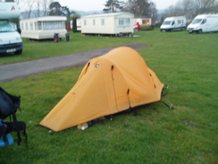
| Pack | Today I carried my 80-litre Macpac Glissade rucksack, containing a North Face Blue Kazoo sleeping bag, my North Face Westwind tent, clothes, waterproofs and other camping items, including cooking gear. |
| Condition | I am utterly knackered after this walk; it has really taken a great deal out of me, mainly as a result of having to press on without stopping. Fortunately I have ni blisters, and I could indeed feel much worse. |
| Weather | The day started off sunny with hazy clouds overhead; as the day drew on the clouds lifted slightly leaving a mostly sunyn day. It was fairly windy, and this brought in a heavy storm that included hail, rain and thnder, after which it dried out considerably. |
| OS map | Landranger number 162 (Gloucester & Forest of Dean) |
 |
 |
|
 |
 |
|
Map of the walk
Maps courtesy of Google Maps. Route for indicative purposes only, and may have been plotted after the walk. Please let me have comments on what you think of this new format. For a detailed table of timings for this walk, please see the table file.
 |
 |
|
 |
 |
|
Notes
The main walk that I had been planning for this year was Offa's Dyke Path, a National Trail that runs from the south of Wales to the north along the Welsh/English border. This is one of the longer National Trails that I have yet to complete, and although it is more than feasible to stay in B&B's or hotels all of the way, it is one that I have always wanted to backpack. It would, however, be the first significant backpack that I had done since my failure to complete Glyndwr's Way in late 2005, and therefore I set off with trepidation just before five in the morning for the half-mile walk down to my local rail station. The heavy load of my backpack weighed down on my shoulders, and I found myself feeling surprisingly nervous about the whole trip.
Fortunately the trains were all on time, and as I waited on the train station at Newport for the final change to Chepstow and the start of the trail I phoned up a campsite in Monmouth to book myself in for the night before re-packing my rucksack ready for the trail ahead, including taking my coat off as the day warmed up.
Just before eleven the final train pulled into Chepstow, and I was soon left with my first choice of the trip. Originally it had been my intention to walk to the start of Ofaa's Dyke at Sedbury Cliffs, but as it was quite late in the morning I decided to take a taxi instead. There was one waiting in the car park outside the station, and the driver opened the boot before I carefully placed my rucksack in.
As the car left the station the car passed the offices of Imagination Technologies, a firm that does business with the one that I work for, and the driver and I chatted away; he gets a fair few walkers being taken to the start of the walk, and he described how ill-prepared many of these were. Hoping that he was not referring to me as the car pulled up on an unsurfaced lane, I got out, retrieved my rucksack and headed off down the path for the few hundred yards to the cliffs.
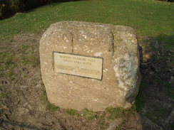
The path fell and rose up to the cliffs for about four hundred yards, an annoying little ascent that tired my legs that had not yet warmed up and blocked all views over the Severn Estuary until the last moment. But then I was there, and through the haze I could just see the bridge and the tall electricity pylons behind, and my mind recalled when I had walked across the bridge as part of my Coastwalk. There was a stone marking the start of the trail, and after starting my GPS recording the route I turned around and headed away, descending down to a little bridge over a stream before climbing up to reach the point where the taxi had dropped me off. Here I asked a passer-by to take the walking poles off the side of my rucksack, the last time that they would be strapped to it before I finished the walk in Prestatyn.
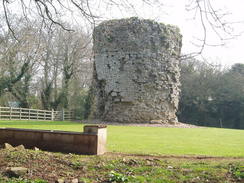
All of my nervousness about the trip left me as soon as I started, and the route was so well waymarked as it headed past Sedbury that I could just daydreamed as I strolled along. The path soon paralleled high above the eastern bank of the River Wye, with large expanses of mud visible as the tide was well out, half-beaching a ship that was unloading sand at a wharf on the other side of the river. After the walk left the river and crossed the A48(T) it became more pedestrian, with only occasional views over the river towards Chepstow and it's castle on the other side of the river, which looked remarkably intact. The path climbed up through a grassy area of parkland and passed Tutshill Tower in a garden on the right, and old 16th-Century beacon that was heavily eroded at its base.
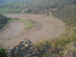
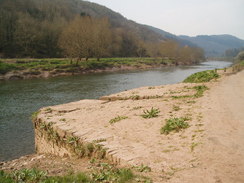
The next good views were obtained from Wintour's Leap, where the path runs along the top of limestone cliffs high above the River Wye, the cliffs made precipitous by an old quarry. A long loop in the river was visible below, but as time was short I only studied the views for a minute and instead headed on along the path, which joined a busy main road for the next short distance. By this stage the rucksack was already starting to starting to cause my shoulders to ache, and although this was not at this stage bad it was not a good sign for so early in the walk.
On the way I passed what must have been the first barbecue of the year in the garden of a house and then suddenly once the path left the road I was on Offa's Dyke, a two-mile stretch of which is in the care of English Heritage. The ditch was clearly visible as was the bank, although the entire area was full of trees, blocking out most of the views down towards the river below. It we obvious from the alignment of the bank and ditch - the ditch being on the Welsh side of the bank - that it would have made a reasonable defensive structure, although quite how they would have manned it I do not know.
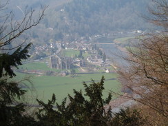
After a short distance a sign stated that the path had been diverted to stop erosion of the dyke, and a fairly pedestrian walk along a track followed just below the dyke, before rejoining it to Plumweir Cliff, where I got my only decent view of the ruins of Tintern Abbey below on the other side of the river. More woodland walking alongside the dyke took me north to the Pulpit Rock, a spectacular stack of rock standing proud from the cliff face. The weather was turning out to be really nice, better than I could have hoped for, and this meant that on the slight ascents I was starting to sweat a little.
The walk continued on through trees for a long while, before eventually leaving the trees as it descended down towards the village of Brokweir. Just before a farm was reached there was a signpost denoting a junction in the paths; this is the only place where there is an official alternative route for Offa's Dyke path, and I decided to take the lowermost route beside the river rather than try and haul myself over the hills on the more direct route. I descended down to the village and thought that the pub was appealing; I did not have time, however, and so I started walking along the pretty riverbank.
It soon started to spit with rain, which soon stopped to be replaced with sunshine before I got drunk. The river here is still tidal, and there were still banks of mud exposed on either side of the water. On the floodplain to my right was driftwood, showing how high the river floods after heavy rainfall, something I always find amazing when rivers are low. On the other side of the river was Llandogo village, and a herd of deer passed to my right as I walked past. Shortly after passing level with the church the clouds overhead started to darken and it started to hail, mixed in with a couple of cracks of thunder, and as I struggled to replace my fleece with my coat I got soaked by large hailstones coming straight into my face. I walked on directly into the hail, feeling miserable that such a lovely day had changed so suddenly.
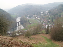
The bridge at Bugsweir was soon reached and passed, and as I started uphill along the road the hail and rain started to cease, and the clouds overhead parted to reveal more sunshine. Unfortunately at the car park I went wrong and took the wrong track; this soon became obvious and I headed along a steep stepped path that led uphill through the trees to reach the path proper at the top treeline. The track was not marked on the map, and I found the next few hundred yards towards and past Coxbury Farm to be very difficult and I was finding it hard to get my breath as I walked along a alight ascent that should be untroubling. This showed me exactly how unfit I was, as today's walk was not too difficult in any way.
The path went through another area of woodland and I continued to feel rather under the weather, enough so that I even considered cutting today's walk short and stopping in Redbrook instead of Monmouth. I started to feel slightly better on the descent into the village, however, and the views over the river and an old railway bridge across it were pleasant. Once down in the village I nipped into a small shop that was still open despite the advancing hours and bought a bottle of water a a bar of chocolate to help cheer myself up. The main road was fairly busy and walked past a sign stating that Monmouth was only three miles away - it could not come too soon for me.
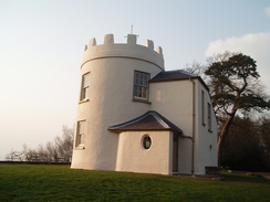
On the map the next ascent seemed steep, but it did not prove to be too bad as it initially followed a road, passing a bridge that carried an old railway line on an incline, the steepness of which was quite impressive. The path followed Duffield Lane, which soon became rough before surprisingly becoming immaculately surfaced for a distance as it continued to climb. Fairly soon I passed a car park and reached the two buildings at the top of the Kymin; one a Naval Temple and the other a white building that was starting to glow red as the sun continued to sink through the evening. The views should have been expansive, but the haze foreshortened them considerably and spoiled them to such a degree that I could barely see anything past Monmouth.
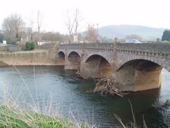
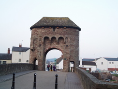
I could not afford to spend too long, and started off on the path that led down through trees towards Monmouth. Initially the descent was through a dark boulder-strewn landscape, before joining a road that continued to descend before joining a road on the outskirts of the town. A quick jaunt across the bridge over the Wye took me into the town proper, and although I had expected this to be the end of the day it did not prove to be; the campsite that I was booked into was about a mile further on, and this meant that I had to walk on through the town, which had some pretty buildings in it. There was a statue of a man holding an early biplane, which turned out to be either Sir Henry Rolls or Royce, I cannot remember which, and parked by this were two stretch limousines and a group of women dressed in seemingly-identical leopardskin outfits. The road continued on downhill before reaching the bridge over the River Monmow, which is complete with a thirteenth-Century gatehouse, the most complete example in Britain.
The campsite was a few yards further on from the other side of the bridge, and I booked in with the owner before quickly erecting my tent at the spot he had indicated, which was unfortunately near the rubbish bins, the plastic bags of which were rustling noisily in the wind. It was starting to get dark, so I quickly got out my cooking gear and cooked myself some sausages and mash, available from Waitrose. I was starving and I wolfed the food down before getting changed in the tent.
By nine it was well and truly dark, and I decided to head out for a drink. My legs were aching by this stage, and when I found that the nearest pub was absolutely heaving with people (it was a Saturday night, after all), I decide to leave and wet back to my tent to get some sleep. Unfortunately at first this was not possible, as about twenty yards away there was a security light that was shining right at the tent, and this stopped me from being able to sleep.
When I finally did get to sleep I was awoken just before midnight by some children (presumably returning from the pub with their parents) who were shouting that they were going to jump on the tent. As mine was the only tent on the site I switched on my headtorch, looked out of the tent and shouted "DON'T YOU DARE!" at the top of my voice. As I was wearing a balaclava as well I must have looked quite a sight, and they apollogised before leaving. Fortunately after this the security light went off, and I could get a good night's sleep.
Directions
| The walk is covered in detail in the Offa's Dyke National Trail Guide South (Chepstow to Knighton), by Ernie and Kathy Kay, and Mark Richards, ISBN 1-84513-274-2 published by Aurum Press Ltd. Click on the image to the right to go to the Amazon page for the book. | 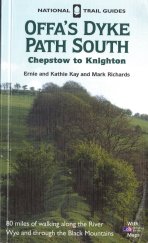 |
Distances
| From | To | Distance (m) | Ascent (ft) | Descent (ft) |
|---|---|---|---|---|
| Sedbury Cliffs | Brockweir | 8.5 | 1677 | 1716 |
| Brockweir | Bigsweir Bridge | 3.5 | 40 | 30 |
| Bigsweir Bridge | Redbrook | 3.9 | 778 | 768 |
| Redbrook | Monmouth | 4.1 | 814 | 830 |
This makes a total distance of 20.0 miles, with 3309 feet of ascent and 3344 feet of descent.
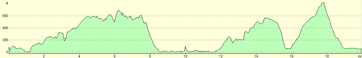
For more information on profiles, ascents and descents, see this page
Accommodation
I spent the night at the Monnow Bridge Caravan Site, Drybridge St, Monmouth, NP25 5AD. Telephone: (01600) 714004. This campsite is right in the middle of the town, and is well kept and maintained with many good faciltiies in the area.
Disclaimer
Please note that I take no responsibility for anything that may happen when following these directions. If you intend to follow this route, then please use the relevant maps and check the route out before you go out. As always when walking, use common sense and you should be fine.
If you find any information on any of these routes that is inaccurate, or you wish to add anything, then please email me.
All images on this site are © of the author. Any reproduction, retransmissions, or republication of all or part of any document found on this site is expressly prohibited, unless the author has explicitly granted its prior written consent to so reproduce, retransmit, or republish the material. All other rights reserved.
Although this site includes links providing convenient direct access to other Internet sites, I do not endorse, approve, certify or make warranties or representations as to the accuracy of the information on these sites.
And finally, enjoy your walking!
This walk was mentioned in the following routes:
| Offa's Dyke |
Nearby walks
| # | Title | Walk length (miles) |
|---|---|---|
| 369 | Clevedon to Severn Beach | 18.6 |
| 370 | Severn Beach to Redwick | 17.7 |
|
|

|