Walk #850: A walk from West Lavington to Bratton Camp
 |
 |
|
General Data
| Date Walked | 15/04/2010 |
| County | Wiltshire |
| Start Location | West Lavington |
| End Location | West Lavington |
| Start time | 08.05 |
| End time | 15.25 |
| Distance | 19.2 miles |
| Description | This was a pleasant walk following the Wessex Ridgeway across the northern side of Salisbury Plain. |
| Pack | Today I carried my 30-litre Karrimor rucksack, filled with waterproofs, a book and other odds and ends. |
| Condition | I feel fine after this walk. |
| Weather | The morning was grey, but the cloud parted as the day progressed. There was a failry chilly breeze that forced me to keep my fleece on, even when the sun was out. |
| OS map | Landranger number 184 (Salisbury & The Plain, Amesbury) |
 |
 |
|
 |
 |
|
Map of the walk
Maps courtesy of Google Maps. Route for indicative purposes only, and may have been plotted after the walk. Please let me have comments on what you think of this new format. For a detailed table of timings for this walk, please see the table file.
 |
 |
|
 |
 |
|
Notes
I was in two minds about what to do about this walk; logic dictated a 20-mile walk from West Lavington all the way around the western edge of Salisbury Plain to Heytesbury. However, there was no obvious way to get back using public transport, and the military ranges prevented a walk back across the plain. Reluctantly I decided that I would have to walk halfway and then head back the way I came, something I have not done for years as I prefer linear or circular walks. On my previous walk I had noted a parking space by the church in West Lavington.
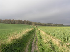
It did not take me long to pull my kit together, and I was then heading off through the village. It took me a while to find the place where the Wessex Ridgeway headed off the road; on the map it is the centre of three footpaths heading off. In the end I found the entrance behind one of the several vans parked in the little lay-by. A series of footpaths headed off, skirting what looked like the playing fields of a new school. Eventually they started climbing up the flank of Strawberry Hill, falling down once more before joining a track that headed up to the top of the hill.
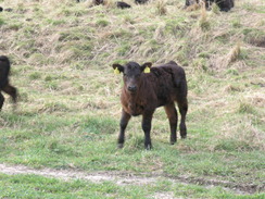
I was not feeling too happy as I walked, the idea of having to return via the same route. There were some good views to be had from the top of Strawberry Hill, but soon enough the route descended once more. Navigation here was made more difficult because it was on the boundary of two pages of the guidebook; in the end I worked out it followed a deeply-rutted chalk track downhill. I diverted around a herd of very young calves and their protective mothers.
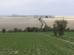
Soon the great flank of Salisbury Plain rose up in front of me. On the map the path rose up diagnolly across the hill, but there was no obvious path on the ground. The vague track I was following turned sharply to the right and kept to the bottom of the ridge. Tracks from off-road motorcycles or quadbikes scarred the hillside, so I decided to just head uphill to reach the road that skirts the northern edge of the Imber military range that dominates the western end of Salisbury Plain. It was a bit of a puff to reach the top, but soon I was striding along a good-quality road.
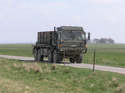
A large group of military vehicles could be seen off to the left near New Zealand Farm Camp; I yearned to get closer to get a better view, but there was no way I was going to trespass on the military ranges. As if to emphasise that thought, large bangs started to rip the air as the army started firing once more.
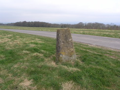
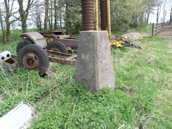
The forecast was for bright sunshine, and I was disappointed that grey clouds had greeted me this morning. Although the clouds were no lighter, the views to the north were still spoilt. To make matters worse the wind was biting, and I was chilled despite having my fleece on. The tarmac became a rougher surface as it continued on, becoming tarmac once again by the time I reached a slanting roadside trig pillar.
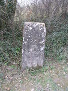
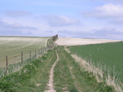
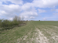
There was not much to report for the next couple of miles; a couple of old, worn milestones were passed, and as the track started to descend the Wessex Ridgeway started to follow a footpath across the flank of Tinhead Hill. Again the good views were spoilt by the low cloud. It was a relief when the footpaths dropped me off on another road near Reeves Farm. A gatehouse guarded an entrance onto the ranges, signs warning of all sorts of severe consequences for people silly enough to enter without permission. Fortunately I had no reason to, and the road took me uphill to the west.
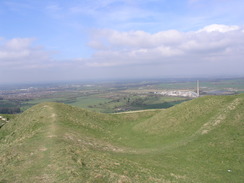
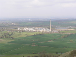
White Horse Farm dominated the top of the hill, and I got glimpses of a trig pillar in the farmyard. Here, however, the way headed off to the north across Bratton Down, the first real grassy walking of the day. Ahead the low ramparts of a hillfort became visible. A car park is on the hill (which will be handy as a start point for the next walk), but I headed off for the fort. Although the ramparts do not seem too high from the south, once on the top they appeared much more impressive. I did not want to explore too much as my stomach was rumbling, so I walked along the ramparts looking for somewhere out of the wind to eat. Litter was everywhere - crisp packets, empty bottles of pop, burger wrappers, all contrasting harshly with the luscious green grass. It was sad to see that people do not respect such a beautiful spot.
I found a good place at the western end of the fort (near an empty bottle of coke) and huddled down on the grass to keep put of the wind (after checking the grass for ants given the problems on the last walk). It was a superb spot on which to eat my sandwiches, and as the sun slowly started to emerge from the clouds I started to feel a little better about the day.
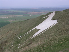
Eventually it came time to head off once more. The return journey promised to be boring, as I would be taking exactly the same route by which I came. First, however, I got a surprise - I was sitting about five yards from the top of a large white horse, cut into the turf of the hillside below me. I have passed many of these in the past, and saw several earlier on in the Wessex Ridgeway walk, but this was the first time I had seen one from this sort of angle, and well enough to take a meaningful photo.
The journey back to my car just flew by, and was nowhere near as boring as I had feared. As I had already walked the route it was navigationally easy and I could concentrate on the podcasts I was listening to. The views were also far better; the haze had lifted somewhat and the clouds were more broken. On a stretch of path I met a couple walking in the opposite direction; they were walking the first three days of the Wessex Ridgeway, and were ending this trip in Westbury, immediately below the white horse and hill fort. They were the first people walking the way that I had met during my trip along the way, and it was pleasant to feel that I was not alone in walking it.
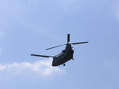
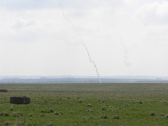
My feet started to ache as I strolled along the roads and tracks along the edge of the range. Suddenly two Chinhooks swept directly overhead, lower than I had ever seen one before. They angled towards the New Zealand Farm Camp, and suddenly a couple of smoke trails erupted up from the ground. The Chinhooks dived down below a hill before emerging again a couple of minutes later, along with more smoke trails. Ahead of me a convoy of army vehicles and lorries sped along the track before heading for the camp. It really looked as though they were having fun, and I stopped for a while to watch them play.
I had assumed that it would be easier to find the path descending from Littleton Down than it was to find it from the bottom, but that was not the case. I headed down the tummocky grass in roughly the right direction, but there was no sign of any path. Fortunately I knew where I had to head to, on my track log when I got home showed that I was more or less on course.
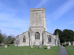
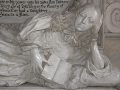
The climb up Strawberry Hill was a bit of a puff, but the unfolding views on the descent down towards West Lavington more than made up for my aching feet. Before I knew it I was back at the church and my car. Instead of heading straight back I entered the church to have a look around. Three women were arranging flowers ready for a wedding on Saturday and I chatted to one of them as I explored. She pointed out a new window by Whistler, and I headed off to look at the exquisite Danves memorial. It had been an unexpectedly pleasant stroll, although it would have been better if the skies had been clearer and the wind weaker.
Directions
|
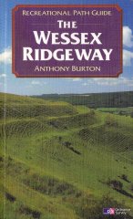
The entirety of this walk follows the Wessex Ridgeway. The route of the Wessex Ridgeway is detailed in the 'Wessex Ridgeway Recreational Path Guide', by Anthony Burton, ISBN 1 85410 613 9 published by Aurum Press Ltd. |
 |
Distances
| From | To | Distance (m) | Ascent (ft) | Descent (ft) |
|---|---|---|---|---|
| West Lavington church | Bratton Camp | 9.6 | 1102 | 768 |
| Bratton Camp | West Lavington church | 9.6 | 768 | 1102 |
This makes a total distance of 19.2 miles, with 1870 feet of ascent and 1870 feet of descent.
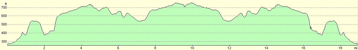
For more information on profiles, ascents and descents, see this page
 |
 |
|
 |
 |
|
 |
 |
|
 |
 |
|
 |
 |
|
Disclaimer
Please note that I take no responsibility for anything that may happen when following these directions. If you intend to follow this route, then please use the relevant maps and check the route out before you go out. As always when walking, use common sense and you should be fine.
If you find any information on any of these routes that is inaccurate, or you wish to add anything, then please email me.
All images on this site are © of the author. Any reproduction, retransmissions, or republication of all or part of any document found on this site is expressly prohibited, unless the author has explicitly granted its prior written consent to so reproduce, retransmit, or republish the material. All other rights reserved.
Although this site includes links providing convenient direct access to other Internet sites, I do not endorse, approve, certify or make warranties or representations as to the accuracy of the information on these sites.
And finally, enjoy your walking!
Nearby walks
| # | Title | Walk length (miles) |
|---|---|---|
| 72 | Bath to Devizes | 19.3 |
| 73 | Devizes to Wooton Rivers | 14.9 |
| 629 | Shrewton to Warminster | 16.7 |
|
|

|