Walk #849: A circular walk from Urchfont to Etchilhampton and West Lavington
 |
 |
|
General Data
| Date Walked | 12/04/2010 |
| County | Wiltshire |
| Start Location | Urchfont |
| End Location | Urchfont |
| Start time | 08.50 |
| End time | 15.01 |
| Distance | 16.4 miles |
| Description | This was a varied walk based around the Wessex Ridgeway, with some valley and hill walking. |
| Pack | Today I carried my 30-litre Karrimor rucksack, filled with waterproofs, a book and other odds and ends. |
| Condition | I feel absolutely fine after this walk. |
| Weather | There was a fair amont of sunshine during the day, but a chilly breeze meant that I kept my coat on for the entire time. |
| OS map | Landranger number 173 (Swindon & Devizes, Marlborough & Trowbridge) and Landranger number 184 (Salisbury & The Plain, Amesbury) |
 |
 |
|
 |
 |
|
Map of the walk
Maps courtesy of Google Maps. Route for indicative purposes only, and may have been plotted after the walk. Please let me have comments on what you think of this new format. For a detailed table of timings for this walk, please see the table file.
 |
 |
|
 |
 |
|
Notes
I felt like doing another day of the Wessex Ridgeway today, so I set off early in the morning for the drive to Urchfont. My GPS took me on a rather winding route, but I soon found myself in the centre of the village. I had never been there before and had no idea about the parking situation, so I followed my usual ploy of looking near the church, as they often have parking spaces. Unfortunately Urchfont church is situated at the end of a narrow lane. There was, however, a car park at the nearby village hall, and I parked in there after asking a local dogwalker if it was okay.
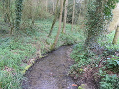
It did not take me long to get my kit together and I was soon heading off. If I was honest I was not looking forward to this walk - I had wanted to reach Urchfont on my last walk, but had had to turn back at Etchilhampton Hill, three miles short. This meant that I was having to go to the hill before following the Wessex Ridgeway back to Urchfont and continuing on, turning the day into a figure of eight walk rather than a circular one. A narrow path squeezed along the side of the hall before dropping down to reach a stream, with a small, compact sewage farm on the left. I crossed a little footbridge above a watery cascade and walked on before realising that I was going the wrong way. A quick climb back up to the footbridge and some steps took me to the field tops.
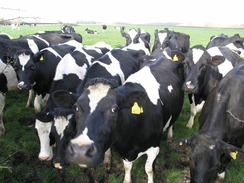
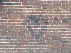
What followed was a fairly uninteresting stroll to the A342 road. It was valley walking at its worst - boggy stretches of track, smelly farm fires and herds of worryingly inquisitive cows. All the time Etchilhampton Hill loomed up ahead, taunting me, as if saying you'll never make it'. Throw in a thoroughly unhealthy bird-much covered stile and the day was looking as unpromising as I had feared. Things got slightly better after this as little items of interest raised my spirits (oh, how fickle I am!) - a heart shape in blue bricks on the side of a house; horsehoses hanging on the wall of a barn.
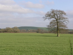
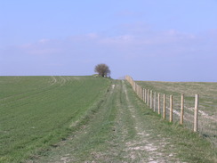
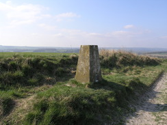
On the way into Etchilhampton I got passed by an electric milk cart; I stepped to one side to let him past on the narrow road. The village itself was compact and the houses expensive-looking - a pleasant place to live. Again the milk cart passed me, the driver giving me a little wave. A road took me uphill, and I then turned off to follow a track that took me up to the summit of Etchilhampton Hill. The views to the north were superb, although the skies were hazier than they had been on the last walk. After taking a few photos of the pillar and the views, a track led down a short distance to join the Wessex Ridgeway and, after 3.5 miles, the Wessex Ridgeway proper started.
A long, sunken lane led down to the A342. The milk cart was heading along the main road as I crossed it, the driver giving me a quizzical look as I passed. Understandably so - he had seen me three times in the course of an hour, and each time I had been heading in a different direction! The way bypassed the hamlet of Stert and followed a lane southwestwards, passing the abutments of an old railway bridge before views unfolded up towards the church on the ridge. Suddenly I started to feel much more positive about the walk ahead.
Steep steps led up an embankment to cross the main London to Bristol railway line, which I crossed quickly and descended the steps on the other side. Paths and tracks led towards Knights Leaze Farm; the paths on the map appeared to have been blocked off by new fences, but it was easy enough to follow the track that paralleled them. Yet again the lack of Wessex Ridgeway waymarkers made life slightly more difficult for me as I tried to find the path that would lead me back to the village.
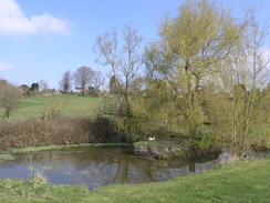
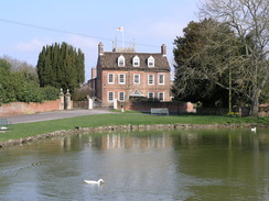
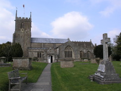
Urchfont was a little livelier than it had been a couple of hours before. It was a nice village, with a community shop (presumably opened to replace the post office). One spot in particular was pleasant; a pond in front of a grand house, with flag-bedecked tower of the church behind. It was a perfect place to stop for a break, but I wanted to press on.
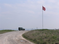
A path started to lead me uphill onto the northern edge of Salisbury Plain. Loud bangs ripped the air - explosions on the range, I guessed. The noise is quite strange at this distance; not as much like thunder as you would expect, but low and growling. As I reached the top of the hill I started off along the track that runs along the edge of the range. A red flag told me that the ranges were inaccessible to the public (useful for the deaf, I guess), and an army Land Rover sat silently beside the track. Clouds of dust hung in the distance, slowly growing in height as they dissipated.
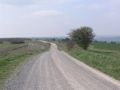
The track made for a pleasant, easy stroll, often with good views to the north. At one point I passed a simple memorial to a German soldier who had died - presumably whilst on exercise on the plain. Later on a hut was passed, outside of which was a lorry and a land rover with range warden' written on a sign on the roof.
I wanted to look for a place to stop for lunch, but there seemed few places to rest out of the fairly chilly breeze that was blowing along the hill. The views were enjoyable as I walked along, band all too soon I reached the point where the way dropped down off the hillside (near the amusingly-named Brazen Bottom Farm'). A row of towers lined the plain in the distance - possibly watch towers or water towers. The track leading downhill was sunken, and it seemed like a perfect place to stop to eat lunch.
After inspecting the long grass for nettles and brambles I sat down on the bank, happy that I was sheltered from the breeze. Sencan had made me a few rounds of sandwiches, and I happily munched on these as I listened to my Walkman. Suddenly I felt itching high on my back, as if sweat rash was forming. I reached to scratch my back when I felt the first bite. A few seconds later I was standing on the track in my boxer shorts, picking ants off my skin and chest hair. I was literally crawling with them (or, more accurately, they were crawling on me). A range warden Land Rover passed close by on the main track, but did not stop to see why this half-naked man was doing some form of ritual dance - perhaps he was a little concerned!
It took me a few minutes to clear all of the ants I could find off my body - I had to use my shirt to try to wipe them off my back. Then my rucksack and clothes had to be cleaned off, during which small pinpricks on my lower back showed where I had been bitten. There did not seem much point in hanging around, so I got dressed, put my rucksack on and headed off down the track.
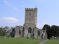
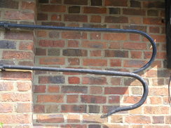
The church in West Lavington has an unsual feature; a bridge linking it to the graveyard extension across the road. Near the church I left the Wessex Ridgeway and started along the main road through the village. On the side of a building were two long-handled hooks; each handle was at least twenty feet long and the iron hooks looked ancient. A nearby plaque said that these were the village fire hooks, used to pull thatch down off burning buildings. It was good to see that a piece of village history was on such prominent display.
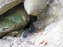
A lane took me down from the main road to a pretty clump of houses near Manor House Woods. A stream trickled through the secluded, steep-sided valley, but a track was soon leading me uphill. This was steep, and was literally cut through the rock to reduce the gradient. Twisted tree roots hung down like some form of alien parasite, and it looked as though it may have looked exactly the same way for centuries. Halfway up I came across a young squirrel on the track; it stared at me and I stared at it before it bolted. Instead of heading up one of the many tree roots it tried to dive into a gap under a root; the space was too small, and the squirrel dug with its feet to enlarge the hole. Eventually its body was fully within the hole, its bushy take sticking out like a bushy flagpole. I had never seen a squirrel dig before, and it was an odd, curious sight.
The track soon levelled off and became greener, passing some woods before ending at a road in Northbrook. An Apache helicopter flew by in the distance, heading towards the plain. A stroll along a quiet road was followed by a long series of tracks, the only views being south towards the plain. The tracks dumped me out onto the B3098 road, which was a hassle to walk along despite not being too busy. There is a track paralleling to the south of the road, and this would have been a much better route.
Urchfont looked pretty in the sunshine, and I soon reached my car in the car park. I had not been looking forward to this walk, but it had been a surprisingly entertaining day, despite the ants!
 |
 |
|
 |
 |
|
Directions
|
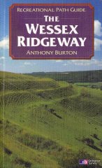
This walk starts off at the car park of the village hall, near to the church. Leave the car park and then turn right, squeezing down a footpath that runs between a road on the left and the hedge beside the hall on the right. The path is narrow as it descends northwards down into a valley, entering an area of trees. Just before a footbridge of a stream is reached, turn right and climb up some steps to the right. The footpath emerges into some fields. Head north across the field, joining a track as it squeezes through a gap in a hedge. From here it turns slightly to the right, becoming a more distinct and boggy track as it heads north to cross a track called Marsh Lane. The footpath continues northwards from Marsh Lane, crossing a series of stiles with hedges on the right. Eventually it emerges into a more open field. Continue straight on, aiming to the right of the buildings of Marsh Farm. Cross a stile and then turn to the left, following a hedge on the left as it skirts the farm to reach another stile on the A342 road. Turn left along the A342 as it crosses a railway line on a bridge. Pass an old pub on the right, and immediately after it turn right through the old pub car park. A path passes the entrance to a caravan park before climbing up an old railway embankment. Cross the embankment and then descend down the other side. A path leads on northwards, soon reaching Wabi Farm. It skirts the edge of the farmyard, passing under a large metal canopy before reaching a road. Turn right along the road and follow it as it immediately turns to the left to head in a more northerly direction. After half a mile a road junction is reached; continue straight on as the road curves to the right to enter Etchilhampton. At SU045604 take the first road off to the left, which starts to climb uphill. At SU042608 Turn left to start following a track that heads southwestwards as it climbs up Etchilhampton Hill. Pass the trig pillar and descend down the track until it ends at a T-junction with another track at SU031600 beside a small chalk pit. From here, the route follows the Wessex Ridgeway for eight miles until it reaches West Lavington. The route of the Wessex Ridgeway is detailed in the 'Wessex Ridgeway Recreational Path Guide', by Anthony Burton, ISBN 1 85410 613 9 published by Aurum Press Ltd. |
 |
|
Leave the Wessex Ridgeway when it leaves the road at SU005531. Instead of joining the footpath, continue along the road as it curves to the left to reach the A360 opposite an ornate arch. Turn left and follow the A360 as it heads northwestwards through the village for 0.7 of a mile, crossing the B3098 road until Russell Mill Lane leads off to the right at ST999540. Turn right and head down the lane. At the bottom of the hill cross a bridge over a stream and follow the lane as it curves to the left; as it does do, turn right up a rough track that heads uphill to the northeast. The track heads steeply uphill before levelling out, passing along the northern edge of some woodland. Continue on until the track ends at a road in Northbrook. Turn left along this road and follow it as it heads northwestwards; at a junction turn right along another road. This twists and turns northeastwards. After half a mile it turns to the right at SU013556; here continue straight on along a track for 1.6 miles. It curves to take a more easterly course, and then at SU033568 turns to the right to head south for a short distance to meet the B3098 road at Newsyde Farm. Turn left to follow the B3098 road eastwards into Urchfont. Take the first road to the left, and follow this as it curves to the right, passing the pub. Just before the pond is reached turn left to head north along a lane that leads to the village hall, where this walk ends. |
|
Distances
| From | To | Distance (m) | Ascent (ft) | Descent (ft) |
|---|---|---|---|---|
| Urchfont church | Etchilhampton Hill | 3.6 | 350 | 98 |
| Etchilhampton Hill | Urchfont | 2.9 | 161 | 390 |
| Urchfont | West Lavington | 5.1 | 377 | 495 |
| West Lavington | Urchfont church | 4.8 | 285 | 190 |
This makes a total distance of 16.4 miles, with 1173 feet of ascent and 1173 feet of descent.
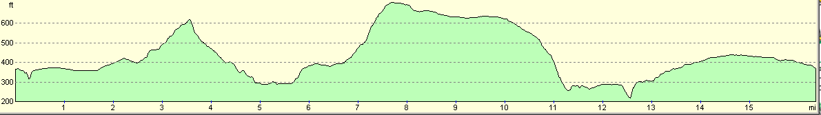
For more information on profiles, ascents and descents, see this page
 |
 |
|
 |
Disclaimer
Please note that I take no responsibility for anything that may happen when following these directions. If you intend to follow this route, then please use the relevant maps and check the route out before you go out. As always when walking, use common sense and you should be fine.
If you find any information on any of these routes that is inaccurate, or you wish to add anything, then please email me.
All images on this site are © of the author. Any reproduction, retransmissions, or republication of all or part of any document found on this site is expressly prohibited, unless the author has explicitly granted its prior written consent to so reproduce, retransmit, or republish the material. All other rights reserved.
Although this site includes links providing convenient direct access to other Internet sites, I do not endorse, approve, certify or make warranties or representations as to the accuracy of the information on these sites.
And finally, enjoy your walking!
Nearby walks
| # | Title | Walk length (miles) |
|---|---|---|
| 72 | Bath to Devizes | 19.3 |
| 73 | Devizes to Wooton Rivers | 14.9 |
| 570 | Swindon to All Cannings | 20.3 |
|
|

|