Walk #848: Avebury to Devizes
 |
 |
|
General Data
| Date Walked | 09/04/2010 |
| County | Wiltshire |
| Start Location | Avebury |
| End Location | Devizes town square |
| Start time | 09.02 |
| End time | 15.54 |
| Distance | 18.2 miles |
| Description | This was a pleasant walk following the Wessex Ridgeway southwards from Avebury to and past Devizes, before taking local footpaths back to the town. |
| Pack | Today I carried my 30-litre Karrimor rucksack, filled with waterproofs, a book and other odds and ends. |
| Condition | I feel absolutely fine after this walk. |
| Weather | Today was fairly hot, with a sun that was strong enough to cause sunburn. |
| OS map | Landranger number 173 (Swindon & Devizes, Marlborough & Trowbridge) |
 |
 |
|
 |
 |
|
Map of the walk
Maps courtesy of Google Maps. Route for indicative purposes only, and may have been plotted after the walk. Please let me have comments on what you think of this new format. For a detailed table of timings for this walk, please see the table file.
 |
 |
|
 |
 |
|
Notes
I was keen to continue the Wessex Ridgeway, which I started on a walk from Avebury earlier in the week. A little planning showed that I could walk from Avebury to Devizes, and then catch a bus back to my car. It took me longer than I expected to drive to Avebury, but the journey was enjoyable enough and I was still the first car in the National Trust car park when I arrived. I quickly got my kit together before heading into the centre of the village. It was a few minutes before nine and the village shop was not yet open, but the owners kindly enough let me buy a few snacks.
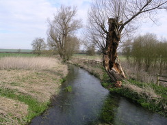
The Wessex Ridgeway leaves the village, and soon crosses the crystal-clear waters of the River Kennet. Tracks and paths took me on to the little hamlet of Avebury Trusloe, where I made the first mistake of the day. I could not find the right path leading out to the southwest and ended up wandering around the road before finding a mud-splattered waymarker on a post. Waymarking is a problem on the Wessex Ridgeway, and I do not expect that it will get much better as the walk progresses.
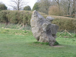
A path took me literally behind the houses, and then a long track took me past a couple of standing stones and on to the A4 road. The next stretch alongside the A4 was hardly pleasant, and despite there being a pavement it was a relief when the Wessex Ridgeway dived off into a layby on the left. After this the walking was much better, as the way followed a track along the route of the Old Bath Road as it climbed over a long ridge. The views were very good, and I got the feeling that this was going to be a very good day's walk. A long earthwork runs slightly to the south of the track, and I wondered what period it belonged to.
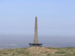
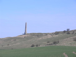
As the Old Bath Road started diving downhill, good tracks took me up towards the grassy ramparts of the fort on Cherhill Hill. Standing proudly above them was the Cherhill monument, which would be visible for the rest of the day. It was tempting to explore a little, but there was still a long way to go, so I took a few photos of the ramparts before descending down off the hill towards the course of an old Roman Road.
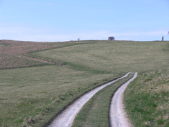
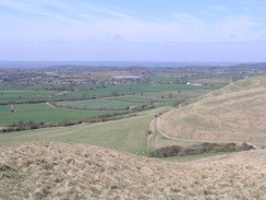
Good views unfolded to the north as the track took me up Morgan's Hill. A steep section took me to a golf course, which had to be crossed carefully as it appeared to be quite busy. It was tempting to divert off to reach a nearby trig pillar, but I was already behind schedule and could not afford the time. Instead I took a series of paths and tracks that took me alongside the edge of Roundway Hill, with some superb views across some sculpted dry valleys to the west.
Soon Oliver's Castle was reached. This is an old hillfort that was altered during the civil war. Roundway Hill was the site of a battle in 1643, where the Parliamentarian army was destroyed by the Royalists. Indeed, many of the Parliamentary cavalry died by falling down the steep hill than were killed in battle. It is difficult to imagine so much pain and suffering in such a beautiful spot.
I headed on, crossing a field and then heading downhill (here there was some variance on the route - the guidebook showed the way following a track across the summit of the hill, whilst the OS map has it a hundred yards to the east). A steep descent followed, and a white horse slowly became visible carved into the hillside to the east. Once on the valley floor a track took me southwestwards towards Devizes. A long stretch of construction fencing guarded a new development off to the left, with diggers, lorries and cranes moving around in an elegant ballet.
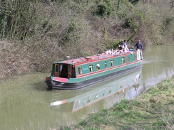
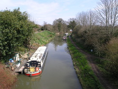
Soon the way reached the Kennet and Avon canal in Devizes. I walked along this stretch of the canal almost ten years before to the day, and it was surprising how many details I could recall. I have walked so many thousands of miles since then, and yet those early walks still hold many precious memories. The water was fairly busy, with canal boats passing by and even a rowing boat filled with four noisy youths being powered along by a small outboard motor!
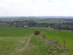
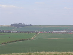
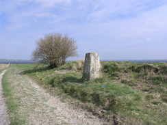
There were no pubs to stop at along the canal, so I followed the Way as it left the canal and started climbing up to the southeast of the town. The white horse became increasingly visible behind me as I walked along a good track, with the outskirts of Devizes close by to the west. Eventually a long climb started, and I diverted off the way to reach the trig pillar at the summit of Etchilhampton Hill. The views from here were superb, especially to the north, and I sat with my back against the pillar as I had my first rest of the day. It was a superb place to stop for a break, and I started to feel remarkably content as the views sunk in. Sometimes walks can make you miserable or ecstatic for no fathomable reason, and this was one of those cases. I must have had lunch breaks in hundreds of more scenic places, yet for some reason this one really made me feel joyous and at one with the world.
I was faced with a difficult choice - I had intended to walk as far south as the village of Urchfont, another three miles further south, before heading back to Devizes. However, it was unlikely that I would be able to get back to the town in enough time to catch a bus that would get me back to Avebury before the car park shut at six. I still felt fit, however, yet there seemed no obvious or easy route to extend the route without walking along the A342 road, which I could see in the distance below me. With some reluctance I decided to head back into Devizes to get the next bus.
A Land Rover pulled alongside me as I strolled back down the track from the summit of the hill. Inside was an archetypal farmer - clothes tattered but still retaining a certain amount of dignity. He was the last native farmer left in the nearby village of Stert, and I got the impression he was checking out this weirdo who was walking along the tracks on his land. I seemed to settle his mind, and he soon left me in a cloud of chalky dust.
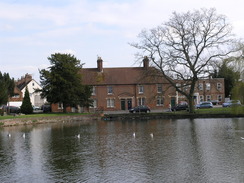
A new school had been built on the outskirts of Devizes, and here I faced another little navigation problem. New schools and roads had evidently been built, and I wandered around a little before I found the correct road that would get me into the centre of town - the layout of the roads was quite different to those shown on my OS map. Near the centre of town I passed a little lake with lots of people around it, all enjoying the April sunshine. An ice cream van was parked nearby, but I resisted the temptation to buy one as I was pushed for time to catch my bus.
I had to ask several times to find the bus station in Devizes (called the bus island'), but I found it soon enough in the market square. My water had run out a good hour before, and so I nipped into the adjacent WH Smiths to buy some water. Unbelievably they did not sell any, so I ran to Superdrug and bought some there. I got back to the bus stop just as the bus was arriving. I was slightly dishevelled amongst the later-afternoon commuters, but as I sat on the bus I looked back on what had been a surprisingly enjoyable day's stroll.
 |
 |
|
 |
 |
|
Directions
|
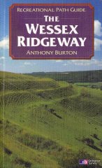
This walk starts off in the centre of Avebury, and follows the Wessex Ridgeway for the first fifteen miles of the day. The route of the Wessex Ridgeway is detailed in the 'Wessex Ridgeway Recreational Path Guide', by Anthony Burton, ISBN 1 85410 613 9 published by Aurum Press Ltd. |
 |
|
It leaves the Wessex Ridgeway near the top of Etchilhampton Hill. Turn back along the track and follow it downhill northwards for three-quarters of a mile, until a track crossroads is reached at SU027612. Turn left and follow this track as it heads westwards, skirting around to the north of Broadway Farm. The track ends at a roundabout, with a school on the left. At the roundabout continue straight on (the second exit), and continue for about fifty yards before turning right to head westwards down Brickley Lane. When this ends at the A361 London Road, turn left and follow London Road for a short distance towards the centre of town. When this meets the A342 turn right, and then turn left down a shopping street that leads to the market square. The bus island is in the centre of the square, near to WH Smiths. (Note that these directions for the centre of Devizes are not particularly good - you may be best off to ask for directions). |
|
Distances
| From | To | Distance (m) | Ascent (ft) | Descent (ft) |
|---|---|---|---|---|
| The Red Lion pub, Avebury | Cherhill Hill | 4.1 | 469 | 161 |
| Cherhill Hill | Oliver's Castle | 5.3 | 436 | 597 |
| Oliver's Castle | Canal in Devizes | 3.1 | 180 | 420 |
| Canal in Devizes | Etchilhampton Hill | 2.7 | 262 | 72 |
| Etchilhampton Hill | The Red Lion pub, Avebury | 3.0 | 89 | 279 |
This makes a total distance of 18.2 miles, with 1436 feet of ascent and 1529 feet of descent.
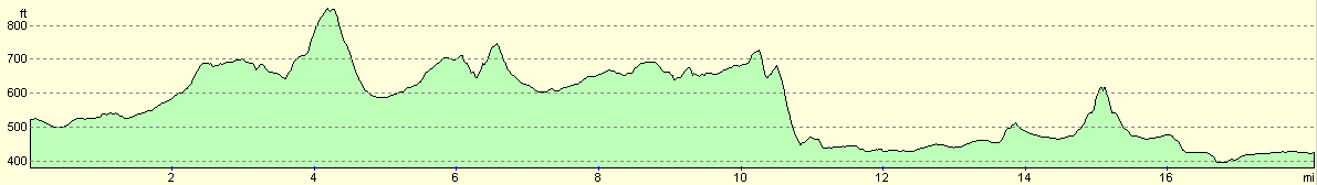
For more information on profiles, ascents and descents, see this page
Transport
There are regular bus services between Devizes and Avebury (the 49 service to Swindon). The single ticket cost £2.20.
Disclaimer
Please note that I take no responsibility for anything that may happen when following these directions. If you intend to follow this route, then please use the relevant maps and check the route out before you go out. As always when walking, use common sense and you should be fine.
If you find any information on any of these routes that is inaccurate, or you wish to add anything, then please email me.
All images on this site are © of the author. Any reproduction, retransmissions, or republication of all or part of any document found on this site is expressly prohibited, unless the author has explicitly granted its prior written consent to so reproduce, retransmit, or republish the material. All other rights reserved.
Although this site includes links providing convenient direct access to other Internet sites, I do not endorse, approve, certify or make warranties or representations as to the accuracy of the information on these sites.
And finally, enjoy your walking!
Nearby walks
| # | Title | Walk length (miles) |
|---|---|---|
| 72 | Bath to Devizes | 19.3 |
| 73 | Devizes to Wooton Rivers | 14.9 |
| 570 | Swindon to All Cannings | 20.3 |
|
|

|