Walk #847: A circular walk from Marlborough to Avebury
 |
 |
|
General Data
| Date Walked | 07/04/2010 |
| County | Wiltshire |
| Start Location | Marlborough |
| End Location | Marlborough |
| Start time | 08.55 |
| End time | 15.31 |
| Distance | 17.1 miles |
| Description | This was a pleasant walk along the first six miles of the Wessex Ridgeway to Avebury, then returning via the hills to the south of the River Kennet. |
| Pack | Today I carried my 30-litre Karrimor rucksack, filled with waterproofs, a book and other odds and ends. |
| Condition | I feel absolutely fine after this walk. |
| Weather | Today was a warm day, but there was a brisk, chilly breeze that meant that I had to keep my fleece on for most of the day. |
| OS map | Landranger number 173 (Swindon & Devizes, Marlborough & Trowbridge) |
 |
 |
|
 |
 |
|
Map of the walk
Maps courtesy of Google Maps. Route for indicative purposes only, and may have been plotted after the walk. Please let me have comments on what you think of this new format. For a detailed table of timings for this walk, please see the table file.
 |
 |
|
 |
 |
|
Notes
It had been a few weeks since my last walk, the weather and events having got in my way. As the days are longer I felt like driving a little further, and I settled on restarting my sectional walk along the Wessex Ridgeway. This was abandoned a couple of years ago after I injured my ankle, and I had not restarted due to the less than illustrious nature of the first parts I walked. To give me a little more encouragement, I decided to restart the walk from the beginning at Marlborough.
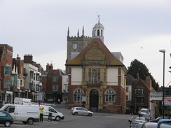
The drive was pleasant, although the M3 was a little congested, and I arrived in the centre of beautiful Marlborough at about half eight. I missed one sign for a long-stay car park, and found another near the Waitrose in town, the entrance to which was almost hidden between two buildings. The parking for a day was about ten pounds, far more than I wanted to pay, but further away in another part of the car park I found more machines, where the cost was a more reasonable £5. It took me a while to get my kit together; it had been some time since I had last used my Olympus C8080 camera, and I discovered that the date and time settings had been lost. I could not find the menu settings to change it (I know, a techie who cannot use his own camera...) so I strode off with it unset.
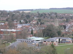
Marlborough is a beautiful town that is somehow demeaned by the curse of traffic. Rows of parked cars clutter up the wide boulevard between the buildings, and cars pass along with no sign of deference for the beauty. I nipped into a baker's shop and bought a couple of sausage rolls to munch on, and then strolled to the start of the Wessex Ridgeway beside the library. There was no sign denoting it as the start, no message sending walkers along the next 120-odd miles of trail. The South West Coast Path has large, artistic signs sending the walker on their way, and it would be nice for all such trails to have something, however little, to mark the start and end points.
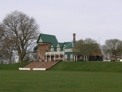
The first mile or so was hardly auspicious; the trail followed a road that headed northwards out of town. The tarmac could be avoided by using a path off to the left, but there were few views to be had. The path overlooked some playing fields, and then what appeared to be a tidy, attractive cricket pavilion, and then ended at a road by a cemetery. From here on it was a choice of following the road or the paths that had been created alongside it, even if that meant delaying golfers about to tee off on the adjacent course.
It was a relief when a track led off westwards, following a horse gallop. Horses thundered along a hillside in the distance, but the walk itself was fairly boring aside from the views. It was a colder day than I had expected, if only because of the chilly wind that forced me to keep my coat on over my fleece. Tears started to fill my eyes as I listened to Lori Lansens' The Girls' on my MP3 player; it is truly a sad but enchanting story about conjoined twins - hardly my usual staple, but a compelling read nonetheless.
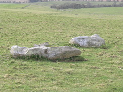
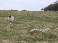
The walk only got more interesting when I reached an area where sarsen stones had been sprinkled around like grey flakes on a green plate. A large part of Stonehenge and Avebury are constructed out of these stones, and here was a natural quarry of them. Locally they are known as the Grey Wethers', a sign of the fact that, from a distance, they look like grazing sheep. Indeed, at one point I did mistake a dirty-coated sheep for one of the stones, jumping with surprise when it suddenly moved.
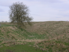
This part of the walk was very pleasant; the path crossed a gallops, and I had to wait for a minute for a tractor to pass. Then came a crossing with the Ridgeway proper, which I walked a few years ago. A long descent down a chalk track led to a farm, and then a road on into Avebury. First the bank was reached, the stretch on the left initially hidden by trees. Some standing stones stood by the deep, grassy ditch, and soon I was at Avebury.
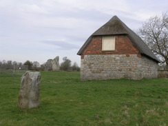
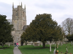
I must admit that I love the village of Avebury. It is perhaps unique in the world - a village built in and around a massive stone circle, ditch and bank. An avenue of stones winds away to the south. It is in many ways a far more impressive and pleasant place than the more famous Stonehenge. I love walking around the bank and running my hands across the surface of the stones, but I would have to leave that for another day.
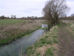
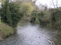
The village itself is equally pleasant, especially on a day like this when it is not overrun by tourists. Here I had to leave the Wessex Ridgeway for the day, and start my return journey over the hills to the south. I continued past the church, before taking a narrow path that led to the National Trust car park. After crossing a main road, another path took me southwards alongside the emergent River Kennett. The water was crystal clear, almost glowing in the first sunshine of the day. Ahead lay my first target of the day.
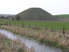
For some time I had known of a trig pillar on Waden Hill to the south of Avebury, and I decided to nip up to the summit to visit it. An open gateway led me into a field, and there was then a stiff climb up to the summit, with some superb views of Silbury Hill behind. Another gateway led me to the pillar. Nearby were two hares standing on their rear legs - they stared at me, and I stared at them, before they bounded off through the long grass. I took a few photos before heading back down to the path. The views towards Silbury Hill would have been superb in better weather, but they were spoilt by a slight haze.
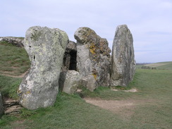
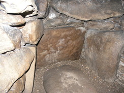
The path took me south past the hill to reach the A4. My route took me across this, and then along footpaths to East Kennett. However a signpost pointed uphill to the West Kennett Long Barrow, one of the best-reserved barrows in southern England. On a whim I climbed the track leading up to it. Massive stones guard the entrance, and the interior was impressive despite having obviously been much restored. Small chambers led off from the main corridor, although a slight smell of pee made me not want to hang around too long. Instead I went and sat outside to eat my sandwiches as more people turned up.
Unfortunately the breeze was fairly strong, and forced me to move off earlier than I wanted. I headed back down the track, and then headed across the floodplain of the formative River Kennet to reach East Kennet. A long road walk led me uphill, during which I talked to Sencan. When the road ended at a T-junction, a track continued uphill towards the West Woods., A car park is marked on the map at this point, but many loads of road grit blocked this off.
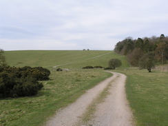
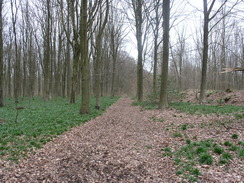
By this point I was starting to feel fairly tired, and another climb faced me. The track plunged into the woodland, and I was soon greeted by an unexpected surprise - a steep dip and equally steep climb on the other side. At the top the track became a path and started skirting the southern edge of the woods, which were fairly dreary, as if spring had not yet touched them. After a while the path led me on through the forest along paths that were in places fairly muddy. At the eastern end of the woods I went slightly wrong, and ended up at a car park.
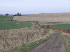
Soon I was at a road in Clatford Bottom, and another path took me steeply uphill, crossing a track to reach another footpath that skirted the top of the path. The route of this path proved hard to find on the ground, but soon I found myself angling across fields, with Marlborough starting to appear in the valley to my left. Soon I was descending down a strange sunken green lane that paralleled the main road to reach a track beside the river. From here it was simply a case of crossing the river on a bridge to reach the centre of Marlborough. The town was bustling, a vast difference to the quiet, sleepy town that had greeted me when I had set off. It had been a pleasant walk, although the return route from West Kennett Long Barrow was not particularly inspiring.
 |
 |
|
 |
 |
|
Directions
|
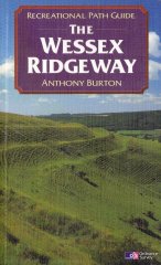
The first six miles of this walk follows the Wessex Ridgeway. It starts off beside the library in Marlborough. Follow the Wessex Ridgeway as far as the Red Lion pub in Avebury. The route of the Wessex Ridgeway is detailed in the 'Wessex Ridgeway Recreational Path Guide', by Anthony Burton, ISBN 1 85410 613 9 published by Aurum Press Ltd. |
 |
|
From the Red Lion pub, walk westwards down the High Street past the church. Turn left down a footpath that squeezes between houses to reach the main car park for the village. Walk through the car park to reach the A4361 road.
Turn right along the road for a few yards and then left, to start following a footpath southwards with the adolescent River Kennet on the right. After 0.8 miles it squeezes past Silbury Hill to reach the A4. Carefully cross the A4, then turn left for a few yards before turning right to join a track that is signposted for the West Kennett Long Barrow. Follow this over a stream, and at the bottom of a hill turn left along a footpath with a hedge on the left. Follow this footpath eastwards; it crosses a road and then starts to curve to the right before joining a track. Turn left along this track to meet a road. Turn right and start following this road as it heads southeastwards for 1.3 miles, initially passing through the little hamlet of East Kennett. It climbs uphill before dropping down to end at a junction with another road at SU131663. Turn left along the road for a short distance, before turning right to join a track. Follow this track as it climbs uphill to the southeast, entering some woodland. It reaches a summit, before descending and climbing once again to reach the southern edge of the woodland. Here the Wansdyke Path is joined; it heads eastwards just inside the edge of the trees for half a mile, until a crossroads in paths is reached. Here take the third track from the left, to continue northeastwards through the trees. Another track is soon reached; turn left along this and after a few yards turn right to continue on northeastwards. When this ends at a better track, turn left to head northwards to reach a track near a car park. Turn right down this track to reach a road in Clatford Bottom. Cross the road and take a footpath that heads steeply uphill to the northeast; when it meets a green track angling up the hillside, turn right along the track for a short distance as it cuts through a hedge. On the other side of the hedge, turn left to start heading northwards in a field, with a hedge on the left. Here the Wansdyke Path is rejoined. After a while the track curves to the right to starts heading diagonally across the field. When this meets another footpath, turn right and follow this path until it reaches a road at SU171675. Turn left down this road for a few yards, and then take another footpath that leads off to the right. Follow this path as it heads in a rough easterly direction along the top of Granham Hill until just before the A345 road is reached. When a shallow valley is met to the left, descend this as it parallels the road to reach a bridleway at the bottom. Turn right along this track to reach the main road beside the River Kennet. Turn left to cross the river, and continue along the road as it heads northwestwards for a short distance to reach the centre of Marlborough beside an old church. Turn right along this road to head towards the library, where this walk ends. |
|
Distances
| From | To | Distance (m) | Ascent (ft) | Descent (ft) |
|---|---|---|---|---|
| Marlborough car park | Avebury | 6.6 | 558 | 443 |
| Avebury | East Kennett | 3.7 | 256 | 302 |
| East Kennett | Marlborough car park | 6.8 | 692 | 761 |
This makes a total distance of miles, with 1506 feet of ascent and 1506 feet of descent.
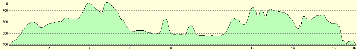
For more information on profiles, ascents and descents, see this page
 |
 |
|
 |
Disclaimer
Please note that I take no responsibility for anything that may happen when following these directions. If you intend to follow this route, then please use the relevant maps and check the route out before you go out. As always when walking, use common sense and you should be fine.
If you find any information on any of these routes that is inaccurate, or you wish to add anything, then please email me.
All images on this site are © of the author. Any reproduction, retransmissions, or republication of all or part of any document found on this site is expressly prohibited, unless the author has explicitly granted its prior written consent to so reproduce, retransmit, or republish the material. All other rights reserved.
Although this site includes links providing convenient direct access to other Internet sites, I do not endorse, approve, certify or make warranties or representations as to the accuracy of the information on these sites.
And finally, enjoy your walking!
Nearby walks
| # | Title | Walk length (miles) |
|---|---|---|
| 73 | Devizes to Wooton Rivers | 14.9 |
| 74 | Wooton Rivers to Kintbury | 16.4 |
| 570 | Swindon to All Cannings | 20.3 |
|
|

|