Walk #865: Ringwood to Christchurch and back
 |
 |
|
General Data
| Date Walked | 03/08/2010 |
| County | Hampshire, Dorset |
| Start Location | Ringwood |
| End Location | Ringwood |
| Start time | 09.33 |
| End time | 17.37 |
| Distance | 21.4 miles |
| Description | This was a pleasant walk following the Avon Valley Path south from Ringwood to Christchurch, before returning via the same route. |
| Pack | Today I carried my 30-litre Karrimor rucksack, filled with water, my waterproofs, a couple of books and other odds and ends. |
| Condition | I feel absolutely fine after this walk. |
| Weather | The day started of bright and sunny, although as time went on the clouds gathered. It never threatened any rain. |
| OS map | Landranger number 195 (Bournemouth & Purbeck, Wimborne Minster & Ringwood) |
 |
 |
|
Map of the walk
Maps courtesy of Google Maps. Route for indicative purposes only, and may have been plotted after the walk. Please let me have comments on what you think of this new format. For a detailed table of timings for this walk, please see the table file.
 |
 |
|
Notes
I had decided to walk the Avon Valley Way, a path that runs from Salisbury in the north to Christchurch in the south. It should have been possible to walk this in two days, but public transport made this slightly difficult. Instead I decided to do it in three separate day walks, two of which would be there-and-back walks, which I usually try and avoid. It did not take me long to reach Ringwood, which is an easy drive home from the A27, and I was soon parked up in the long-stay car park near the Waitrose store. This cost me five pounds for the day; a bit steep, but manageable.
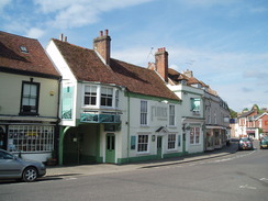
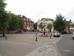
Ringwood is a pleasant town that is spoilt somewhat by the close proximity of the A27 dual carriageway, which cuts just to the north of the town. I diverted off to WH Smiths to buy a few refreshements for the day, before continuing on through the town to reach the church, whose pleasant form is again spoilt by traffic noise. After passing a nice thatched house, and another that had a blue plaque stating that the Duke of Monmouth had stayed there before being hung.
Soon afterwards, the bridge that carries the road over the A27 was reached. Although this path is called the Avon Valley Way, it does not spend much time alongside, or even in sight of, the river - it is much like the Test Way in this fact. This meant that I tried to make the most of the first couple of miles as the path wound around, heading through a caravan park and diverting across a common before reaching an old railway line. On the other side the fine brick arches of the viaduct that carried the railway over the floodplain and river could be seen - although now only used by pedestrians and cyclists as part of the Castleman Trailway.
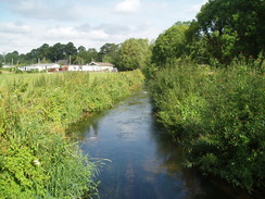
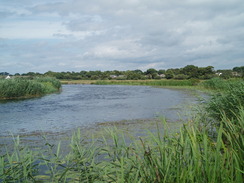
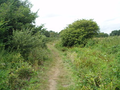
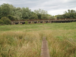
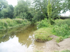
The path headed south along the floodplain. The River Avon past Ringwood is formed of a series of tributaries from the main river that meander around, joining and splitting seemingly at random. I only met the river proper at a footbridge over a mill stream, and it was soon left behind as a green lane continued on southwards. Eventually I reached a series of footbridges that took the path over a complex arrangement of tributaries. It was here that, a couple of years ago, I had had to divert away when walking in the opposite direction because the path north was flooded. It was hard to imagine that the placid and tranquil river had ever had such an angry, swollen nature. A look at the path I had just walked along cemented my feelings that I had done the right thing in diverting - the whole path north to the railway viaduct is low-lying, and it would have meant a long, perilous wade through the waters.
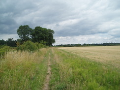
The next mile took me south across Kingston North Common to a main road, which was soon headed away from by a diversion southwestwards towards, but never getting in sight of the river. Another short stretch of common took me out onto the main road again, right opposite Bisterne Church. Unfortunately the next mile of the walk was far from enjoyable, as it followed the road southwards. It seemed to be busier than when I had last walked it, and the verges somehow felt narrower. Although it is not the busiest main road in the county, it is hardly a suitable route for a named trial.
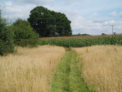
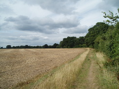
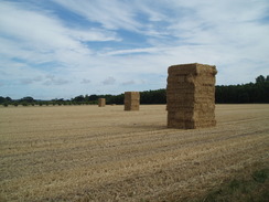
It was therefore a relief when the path diverted away from the main road, entering an area of trees before breaking out into farmland as it headed south. A plane passed overhead, wheels down and flaps extended, heading towards Bournemouth airport which is a little way to the west. A JCB telescopic loader was scurrying around a field, stacking bales of hay into tall piles. Two forms of modernisation intruding into a pastoral scene.
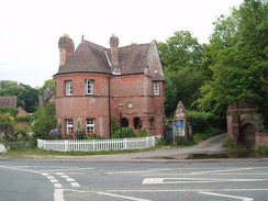
After crossing a couple of roads, the path started following a stream south, although once more the stream was not really in sight. Eventually the path emerged onto the main road immediately to the north of Sopley. The road split into two one-way branches, and I headed against the traffic as I headed south. There was no sign of the post office marked on the map, which means that it has probably fallen victim of the closure programme. The pub in the village nestles in a crook of the road and seemed inviting, but I resisted the temptation to enter.
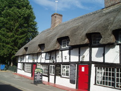
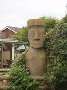
Instead I continued along the path as it passed under an imposing gateway, with an equally imposing gatehouse alongside. What followed was a messy stretch of path, with lots of small fields and paddocks to be negotiated before it emerged out onto a lane. This was followed to the pub in Holfleet, which had an unusual item in the garden - what appeared to be an Easter Island head!
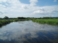
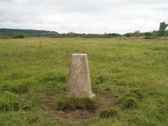
A stretch of bridleway took me south from the pub towards the village of Burton. The stretch of the path through this village proved to be the hardest to negotiate on the entire day, but I managed to more or less keep on track before I crossed the main road and rejoined the river's floodplain. It was a relief to reach this open stretch of ground, as most of the rest of the day had been enclosed on either one side or both. I diverted off the path to visit the nearby trig pillar, before rejoining the path as it headed towards the Avon.
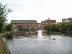
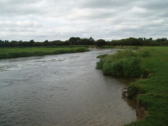
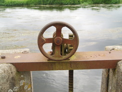
It felt good to have the river for company once more, even if it was only to be for a few hundred yards. Instead of following a bend in the river, the path diverted off across the floodplain to reach a footbridge across the mouth of one of the tributaries. I started to see fishermen scattered along the banks, along with signs about the fisheries in the area. The footbridge was really more of a sluice, with the gates that controlled water into the tributary to one side. This set the tone for the next half a mile, where the path was dominated by a series of grand waterworks buildings, the architecture exemplifying municipal works.
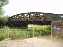
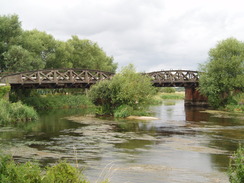
The river proper was crossed by one of the buildings, and a narrow path continued on southwards. Soon a railway line was reached, which the path squeezed under. A series of ?arches? stretched out over the river, the design making the bridge look rather old. This was to be the last I saw of the river for a while, as the path diverted off to the main road in the northern outskirts of Christchurch. I headed south along the road through the town, finding it not quite as pretty as I had expected, with the intrusive shop frontages letting down the buildings they were housed in. The road was also fairly busy, and it is hard for a place to look good with a traffic jam running through it.
I made a diversion into the Tourist Information to get details of the bus times. I was tempted not to walk back, but to go the short distance south to the coast and walk around Hengistbury Head instead. Unfortunately there are only a few busses back to Ringwood each day, and the timings were all wrong, so I decided to return via the same route.
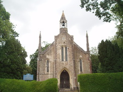
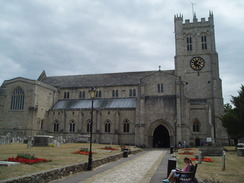
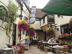
First I had to reach the end (or start) of the Avon Valley Path at Christchurch Priory, a magnificent church set in equally magnificent gardens. It really is a great place to mark the start (or end) of a trail. I took a few photographs before starting the walk back, looking for somewhere to stop for a rest. I soon came across the Ye Olde George Inn, also called YOGI. This was an old coaching inn and was filled with character. I felt slightly out of place in my sweaty walking clothes amongst the other drinkers, but they served me without fuss and I went out to sit in the courtyard.
Signs on the wall stated how some of the rooms near the stables had once been used to house convicts being transported to Australia, and bars had been painted onto a board that fronted one of the windows. Indeed, the place reeked of history, and one could easily imagine it being used as a film set, with a few of the signs of modernity (air conditioning units, etc) being removed and a liberal covering of dirt and straw over the ground. It was the most characterful pub I had visited for some time.
Eventually I managed to drag myself away from the pub and started the journey back northwards. This seemed to fly, totally the opposite of my usual experience in there-and-back journeys, where the return journey drags on. Instead it seemed to take me no time at all to reach Sopley. On the way I passed a couple who had just walked from Ringwood, as the last stretch of their walk along the Avon Valley Path. I congratulated them on (nearly) having completed their stroll, and we chatted about the walk and walking in general. It seems that this path is a surprisingly popular walk, as I have met many people who have walked it.
My feet started to get overly hot as I headed north, especially as I trudged along the main road towards Bisterne. Again this was hardly a good stretch of walk, and it was a relief when I headed off, crossing a stile that was dangerously rickety. The area near the railway bridge to the south of Ringwood was comparatively busy, including one young man who was sitting in the long grass strumming at his guitar! He was so engrossed that he hardly seemed to notice me pass him.
It did not take me long to reach my car, and I could look back on what had been a surprisingly enjoyable stroll. It is a shame that the path cannot remain in the company of the river for longer, but it makes for a good walk nonetheless.
 |
 |
|
Directions
This walk starts off from the long-stay car park in Ringwood, and follows the Avon Valley Path south to Christchurch and back. Leave the car park and head south down Furlong Street, following it as it curves to the right near the Tourist Information office, narrowing before ending at a junction with the High Street. Turn right to head westwards along this, as it becomes West Street. The road curves to the left near the church, and when the road crosses a tributary of the river turn left to continue along the Avon Valley Path.
This heads down a track that leads into a caravan park. Walk to the end of the tarmac, cross a small patch of grass, and then go through a clappergate. Turn half-left to head southeastwards across fields for a short distance until a footbridge is reached over the same stream. Cross this, and on the other side turn right across grass to reach a road. Turn right to head south across Bickerley Common for a short distance, with houses set back on the right. When a road comes in from the left, turn right down a gravel track; as this curves to the left turn right down another track. Pass some houses on the left; a concrete bridge leads across the stream once more, and on the other side climb up a slope onto an old, disused railway bridge.
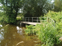
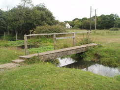
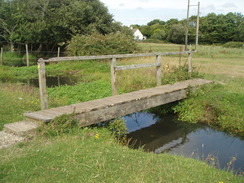
Cross the bridge and go through a stile to enter a field. Turn half-right to head southwestwards for a couple of hundred yards, before turning to the left to follow a hedge southwards. When the hedge ends continue straight on along an obvious path across the field, which soon turns to the left to head southeastwards, crossing a little boardwalk over a boggy area of ground. This reaches a narrow footbridge over a stream beside the River Avon. Cross the bridge and continue on southwards, with the river close-by on the right.
Cross a stile and join a track, that has hedges on either side. Continue southwards along this to a series of three footbridges that cross another tributary of the river beside a ford. On the other side, head south along good tracks that enter Kingston North Common. The path passes a house close-by on the left, and after nearly a mile ends at the B3347 road.
Turn right to head south along the B3347 for a short distance along a sweeping left-hand bend, before taking a road that leads off to the right. A few yards along this, turn left to start following a path that runs along a track southwards. This heads past a couple of buildings before reaching a triangular junction; take the right-hand fork and join a road. Turn right and follow this road westwards for a quarter of a mile to about SU142016.
Here turn left and follow a footpath as it heads southeastwards; the path curves slowly to the left to finally reach an easterly course, before ending at the B3347 after half a mile in Bisterne. Turn right and start following the B3347 road southwards for a little under a mile. The road curves to the right; when a track is reached at SZ149999, turn left and follow the track southeastwards. This enters a patch of trees before curving to the right to head south to reach Anna Lane. Cross the lane and continue on southwards across fields for 0.4 miles until another lane is reached. Cross this, and continue southwards for another 0.6 miles with a hedge on the right. Two narrow bands of woodland are passed before the footpath ends at another road at SZ155981.
Turn left to head east along this road for a short distance until a bridge over a stream is reached. At this bridge turn right and start following the stream southwards for two-thirds of a mile; the back gardens of houses slowly encroach on the right before the path ends at the B3347 road immediately to the north of Sopley. Turn left to head south along the road; when it forks take the right-hand fork through the village. This turns sharply to the left by the Woolpack Inn to reach a complex junction.
Head straight across the junction and head through an imposing gateway, Head up the track for a short distance before taking a footpath that heads off to the left. This skirts the edge of a paddock before passing the driveway leading to an imposing house to the right. Head straight on, and then turn right as the footpath heads southeastwards across a series of paddocks before ending at Harpway Lane at SZ163967. Turn right and start heading south along the lane for a quarter of a mile until it ends at another road; turn right down this road for a short distance until a pub is reached.
At the pub turn left along a lane that passes the pub. After a short distance a stream is reached; cross this bridge and then immediately turn to the right to start following the stream southwards. After a little over half a mile, the footpath ends at a bend in Salisbury Road on the northern outskirts of Burton. Turn left to head south down Salisbury Road; just before Preston Lane comes in from the left, turn right down a surfaced path. This curves to the right before ending at a bend in Morrcroft Avenue. Follow this road westwards until it ends at a T-junction with Priory View Road.
Turn left down Priory View Road and follow it as it curves to the right and then the left. Pass a playground on the right, and then turn right down a surfaced path that heads westwards. This path ends at Pitmore Road; cross this and then continue on westwards down another surfaced path, which eventually ends at the B3347 road once more. Turn left to head south down this road for a few yards, and then turn right along another footpath. This crosses a footbridge and then head south-southwestwards across the floodplain, heading slightly to the south of a trig pillar.
The footpath meets the River Avon at a bend in the river. Keep the river to the right around the bend, and then head towards an electricity pylon. At the pylon turn left to head south-southwestwards back towards a pipe bridge over the river. Do not walk along the river, but instead cross a footbridge over a tributary of the river, and then continue on with the river on the left. Cross another couple of footbridges before a building is reached on the right. Pass this, and then immediately turn to the right to cross another tributary of the river.
Immediately on the other side, turn left to walk southwards with the river on the left. Continue on as the path becomes a track and reaches a railway bridge over the river. Pass under this and continue on along a path on the other side. This turns to the right and follows a track southwestwards for a short distance, before curving to the left before ending at a road called Avon Buildings. Turn right and follow this road for about a hundred yards until it ends at the B3073 road on the northern outskirts of Christchurch.
Turn left and follow the B3073 south-southeastwards to a large roundabout with the A35. Turn left at this roundabout to reach an underpass; use this to pass under the A35. On the other side head southeastwards along the High Street. At a junction continue straight on along Church Street; when this ends at a gate go through it to reach the churchyard belonging to Christchurch Priory. Walk along a surfaced path to reach the church, where the Avon Valley Path starts or ends.
The next section details the return journey.
Leave Christchurch Priory and take the surfaced path that heads north through the churchyard. Go through a gate and join Church Street; follow this northwards until it reaches a junction near the Ye Old George Inn pub. Here continue straight on, heading up High Street northwestwards until a roundabout with the A35 is reached. Head to the right for a short distance to reach an underpass under the A35; used this to cross the road. On the other side head north-northwestwards along the road.
When Avon Buildings is reached at SZ155931, turn right to head along the road. When it ends turn left along a track, and then right to head towards the river. Turn left and start following a footpath northwards. This passes under a railway bridge and then jinks to the right and left to continue north with the river to the right. The path ends at a waterworks building; turn right to cross a bridge over a tributary of the river. On the other side turn left to follow a path northwards with the river on the right, crossing two footbridges before reaching a third. Cross this to reach the floodplain on the other side.
Turn slightly to the left to head northwards towards a pylon in the distance, crossing two small plank bridges on the way. The path reaches the river bank just to the left of the pylon; turn right and follow the river bank eastwards. The river bank starts to curve to the left; as it does so continue on north-northeastwards across the floodplain, heading to the south of a trig pillar. Cross a footbridge and then continue on to reach the B3347 road.
Turn left along the B3347 to hea dniorth for a few yards, before taking a surfaced path that heads off to the right. This path heads eastwards before ending at Pitmore Road. Cross this road and continue on along another surfaced path until Priory View Road is reached. Turn left along this road, and follow it as curves to the right and then the left. Take the first road off to the right, Moorcroft Avenue, and follow this as it heads eastwards. When this road curves to the right continue straight on along a surfaced path, which ends at Salisbury Road.
Turn left and follow Salisbury Road northwards for a couple of hundred yards. When the road curves to the left, head straight on along a footpath that heads northwards for a little over half a mile beside a stream. The footpath ends at Bockhampton Road by a little bridge. Turn left and follow this road northwards until it ends at a T-junction by a pub. At the junction turn right to head northwards along a road for a few yards, and then turn left to follow Harpway Lane northwards for a quarter of a mile.
A footpath heads off to the left at SZ163967. Follow this as it heads northwestwards across a series of paddocks; it then turns to the left past the entrance to a large house. The path keeps a hedge on the left as it winds around past a series of paddocks, eventually joining a tree-lined track that descends for a short distance to meet the B3347 road in Sopley. Carefully cross the road and head towards the Woolpack Inn. Follow the road as it curves to the right to head northwards through the village.
At SZ156971 leave the road, and take a footpath that heads off to the right. Follow this northwards for two-thirds of a mile until it ends at a road. Turn left to head westwards for a short distance, and then turn right past a gate into a field. Follow this footpath it as it heads northwards across fields with a hedge on the left. The path soon squeezes between two sets of trees, and after half a mile reaches another road.
Cross this road and continue on northwards for a little over half a mile; it crosses another road (Anna Lane) before entering some trees and ending at the B3347 road. Turn right and start following this road as it heads northwards for a little under a mile. Opposite Bisterne church a footpath leads off to the left. Follow this footpath as it crosses fields for half a mile, curving to head northwestwards and ending at a road. Turn right and follow this road eastwards; when it curves to the right turn left along a track that leads through Kingston to reach a minor road.
Turn right along this road for a few yards until it reaches the B3347 road. Turn left and follow this road northwards for a short distance around a right-hand bend, then turn left down a footpath that heads northwards for a mile across Kingston North Common, until a footbridge across a stream of the River Avon is reached.
Cross a series of footbridges over a tributary of the river, and on the other side head north along a track between hedges. The hedges end, and the footpath continues on as the river approaches on the left. It meets the footpath at a footbridge over a tributary over the river at SU148041. On the other side of the bridge the footpath turns to the left to head northwestwards across the floodplain.
The path curves to the right to head northwards with a hedge on the right; when a footbridge is reached after a few hundred yards, turn half-right to cross it and head northeastwards across the floodplain to reach the embankment of an old railway line. Climb up to cross this, and join a track on the other side that immediately crosses the tributary of a river. Continue on northwards along this track; as it curves to the right turn left along Kings Arms Lane for a few yards until just before it reaches a road, then turn left to head across a green in front of some houses.
When the houses end, turn left to head westwards for a short distance to a footbridge over the same tributary. On the other side of the bridge, turn right to head northwestwards across a field to reach a caravan park. Head through the middle of this caravan park, heading north along the access driveway. This joins an access road that soon ends at West Street in Ringwood. Turn right and follow West Street eastwards.
At the church follow the road as it curves around to the right, becoming the Market Place. Take the first road off to the left, The Furlong, and follow this as it curves around in a rough northeasterly direction. The road joins another road near the Tourist Information office and continues on northwards to reach a roundabout. The long-stay car park in Ringwood is immediately to the north of this roundabout.
 |
 |
|
Distances
| From | To | Distance (m) | Ascent (ft) | Descent (ft) |
|---|---|---|---|---|
| Ringwood | Sopley | 6.8 | 46 | 79 |
| Sopley | Christchurch Priory | 3.9 | 30 | 52 |
| Christchurch Priory | Sopley | 3.9 | 52 | 30 |
| Sopley | Ringwood | 6.8 | 79 | 46 |
This makes a total distance of 21.4 miles, with 207 feet of ascent and 207 feet of descent.
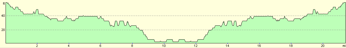
For more information on profiles, ascents and descents, see this page
Transport
The Wiltshire and Dorset bus company run services between Ringwood and Christchurch (175), and Christchurch to Ringwood (176).
 |
 |
|
 |
 |
|
 |
 |
|
 |
 |
|
 |
 |
|
 |
 |
|
 |
 |
|
 |
 |
|
 |
 |
|
 |
Disclaimer
Please note that I take no responsibility for anything that may happen when following these directions. If you intend to follow this route, then please use the relevant maps and check the route out before you go out. As always when walking, use common sense and you should be fine.
If you find any information on any of these routes that is inaccurate, or you wish to add anything, then please email me.
All images on this site are © of the author. Any reproduction, retransmissions, or republication of all or part of any document found on this site is expressly prohibited, unless the author has explicitly granted its prior written consent to so reproduce, retransmit, or republish the material. All other rights reserved.
Although this site includes links providing convenient direct access to other Internet sites, I do not endorse, approve, certify or make warranties or representations as to the accuracy of the information on these sites.
And finally, enjoy your walking!
Nearby walks
| # | Title | Walk length (miles) |
|---|---|---|
| 311 | Milford on Sea to Southbourne | 16.9 |
| 312 | Southbourne to Hamworthy Station | 15.3 |
| 801 | A circular walk from Brockenhurst to Burley | 23.5 |
|
|

|