Walks in Northumberland
Northumberland is a large county in the northeast of England, directly to the south of the Scottish border. It is the sixth largest county in England, but only the 44th in terms of population, detailing its rural nature.
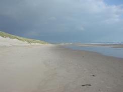
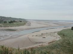
It contains some spectacular scenery, from the Cheviot Hills in the northwest of the county to the long and beautiful coastline. The rugged grandeur of Holy Island and Lindisfarne perhaps exemplify the coast. The Pennine Way runs through the west of the county, and other trails run through, including the start of St Cuthbert's Way and parts of Hadrian's Wall Path.
Below is a map showing all the walks that I have completed in Northumberland.
Completed walks in Northumberland
List of walks in Northumberland
| Walk No. | Description | Distance (miles) |
|---|---|---|
| 931 | Hadrian's Wall Path: Chollerford to Newcastle | 26.9 |
| 930 | Hadrian's Wall Path: Greenhead to Chollerford | 20.2 |
| 929 | Hadrian's Wall Path: Carlisle to Greenhead | 22.2 |
| 231 | East Sleekburn to Howdon | 18.0 |
| 230 | Amble to East Sleekburn | 19.0 |
| 229 | Dunstan Steads to Amble | 15.5 |
| 228 | Ross to Dunstan Steads | 18.2 |
| 227 | Spittal to Ross Links | 15.0 |
| 226 | St Abbs to Berwick-on-Tweed | 16.8 |
| 48 | 18-mile bothy to Kirk Yetholm | 7.2 |
| 47 | Byrness to 18-mile bothy | 18.1 |
| 46 | Bellingham to Byrness | 14.7 |
| 45 | Once Brewed to Bellingham | 15.4 |
| 44 | Slaggyford to Once Brewed | 18.0 |
| 43 | Garigill to Slaggyford | 9.2 |
This was a total of 254.4 miles in 15 walks (an average of 16.95 miles per walk).
|
|
