Walk #121: Royston to Hitchin
 |
 |
|
General Data
| Date Walked | 07/10/2000 |
| County | Cambridgeshire, Hertfordshire |
| Start Location | Royston |
| End Location | Hitchin |
| Start time | 09.20 |
| End time | 15.23 |
| Distance | 17.3 miles |
| Description | This was a pleasant walk along the Icknield Way Rider's Route southwest from Royston into Hitchin. |
| Pack | Today I carried a minimal pack, with no tent or spare clothes. |
| Condition | I was getting tired at the end of the walk, but I have no real trouble with any part of my body after the walk. I do have a slight problem with the fourth toe on my right foot, but it did not hurt whilst I was walking, and only hurt when I got back to the car and changed out of my boots ready for the journey home. I had no twinges from my legs, ankle or back. |
| Weather | Today was wet. Very, very wet. Indeed, on a wetness scale between the Sahara and the Atlantic, today was like the Pacific. It was raining when I got out of my car at Royston Station, and it continued to rain all day at various rates; from a light drizzle to heavy drizzle, to a period of only occasional spots of rain, followed rapidly by heavy torrential rain. I ended up with my clothing soaked, but fortunately on the inside I was only damp and not wet. The wind was annoying at times due to the wet weather, but was not too strong. There was no glimpse of any sun all day, so it was fortunate that it was a reasonably warm day. |
| OS map | Landranger number 153 (Bedford & Huntingdon, St Neots & Biggleswade), Landranger number 166 (Luton & Hertford, Hitchin & St Albans) and Landranger number 154 (Cambridge & Newmarket, Saffron Walden) |
Map of the walk
Maps courtesy of Google Maps. Route for indicative purposes only, and may have been plotted after the walk. Please let me have comments on what you think of this new format. For a detailed table of timings for this walk, please see the table file.
Notes
There was one total overwhelming feature of this walk, and that was of the rain that seemed to fall incessantly all day. Fortunately it did not spoil the day, but there can be little doubt that the walk would have been better if the rain had not featured so heavily. In my opinion rain can bring out the best in a landscape, particularly when that landscape is a green and fertile valley. The train seems to give it a shine that you do not necessarily see in the sun. Unfortunately going hand-in-hand with the rain was the mud, which was particularly bad when crossing from Royston to join the Icknield Way, where I had to cross ploughed fields and ended up with large clods of mud sticking like clay to the undersides of my boots. This made my boots much heavier, and hence the going was much harder when the boots were in that state.
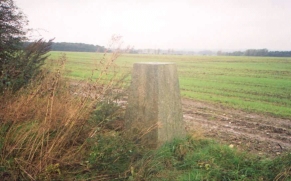
On the map there were two Trig points that were on or very near the route; the first was between the railway and Litlington on Limlow Hill, but unfortunately I could not find it. There is a wooded area at the top of the hill and it cold have been in there, but I could not see it, and due to the weather I did not really feel like exploring further. The second Trig point was at grid reference TL 254362, representing a height of 96 metres. This was right on the route, and commanded nice views (or as far as I could tell in the cloud and rain) in several directions, including a nice vista over the town of Baldock.
There were a couple of unusual points about today's walk. Firstly, despite the fact that I walked over 16 miles, I did not stop once but just kept on walking. The only temporary stops that I had were to take photographs and change the maps over in my case. The rain was so persistent I just did not fancy stopping walking for any reason, and so I just kept plodding on. This was really good going as I would normally stop for about an hour during a walk of this duration.
I also did not drink much fluid during this walk. Normally on such a walk I would probably drink somewhere between one and one and a half litres of water, and more if it is hot or the terrain is strenuous. Today I only drunk a carton of Ribena that I purchased on the way, which meant that I carried about all the water that I had set off with. I guess that with all the rain I was not losing water as fast as would normally be the case and therefore did not need to replace it.
All in all despite the bad weather I really enjoyed this walk. It was a refreshing and relaxing walk of the sort that I wish I could do all the time. Of course, I would prefer it without the rain!
Directions
The majority of this walk follows the Icknield Way, which is generally very well signposted which means that it is quite hard to go wrong, particularly if you pay attention to the relevant 1:50,000 maps. From Royston Station, turn right and head down Knessworth Street southwards towards the centre of the town. At the first major road that you come to turn right down Baldock Road and head westwards. Continue on past Ivy Farm until, shortly before a left-hand bend, a footpath leads off to the right. It crosses a field and a railway line, then another field until it comes to the dual carriageway A505 road. Please note, in 2005 I have noticed that the footpath and bridge over the A505 is no longer present, so you may have to continue along Baldock Road towards a roundabout, from where a footpath heads north, intersecting with the footpath mentioned here to the southeast of Limlow Hill.
Climb up the steps to the A505 and carefully cross it. Descend the steps on the other side and head in the same direction across a field to a small rectangle of woodland. The path enters the woodland about fifty yards from it's eastern end, and soon exits it, again on the same line. The path then continues up to near the summit of Limlow Hill, and then down to meet the Icknield Way just before a road leading to Litlington. Turn left along the Icknield Way for a few yards, and then cross the road.
Follow the Icknield Way, an old Roman Road, for a few miles until you reach the village of Ashwell, entering Hertfordshire in the process. Since it is a Roman Road the path is more or less straight, and route finding could not be easier. The path then passes along tracks and minor roads on the southern edge of Ashwell to the western fringes of the village.
At the western end of Ashwell the Icknield Way turns to the left and passes south over Claybush Hill and then down to meet a road. Follow the road for a few hundred yards until a stream, Cat Ditch, is reached. On the far side of the stream a path leads off to the right along the edge of a field (note that this is shown on the maps to be on the other, northern side of the stream, although the signposts and the path is on the south side). Follow the stream for a few hundred yards before heading uphill following the field boundary to a small area of woodland. The path then skirts this woodland and then twists around to reach a Trig point.
Follow the Way as it heads downhill from the Trig point until eventually the path becomes a track that takes you past a farm and down to the A507. Turn right along the A507 and then very shortly take the first road to the left, heading downhill and under the A1(M).The road follows the River Ibel for a short period before crossing over beside a Mill and heading south through Norton Bury. Another road is reached at a T-junction, next to and above which is another road. Turn left and follow this road for a short distance around to another junction. Take the road into Norton and then onto the outskirts of Letchworth.
Follow the signs that show the route of the Icknield Way through Letchworth. After a while you meet a road called the Icknield Way, that takes you westwards through Letchworth to the north of the railway line. The road bends around to the north before meeting another road at a T-junction.
The Icknield Way heads downhill to the southwest for a mile before passing under the East Coast Main railway Line. It then crosses the course of the old Hitchin to Bedford railway line and a stream before reaching a road opposite a church in Ickleford. Turn left down this road, which is called Arlesley Road.
Follow Arlesley Road down to the church in Ickleford. Just past the church take the left-hand fork in the road and continue south towards Hitchin. After just over a kilometre take the first major road to the left, called Strathmore Avenue, opposite a school. This road leads to a roundabout which you can cross over to join Water Lane. Water Lane soon ends and you can turn right down Grove Road to meet a main road. Turn left down this main road and after a couple of roundabouts Walsworth Road leads uphill to the right just before the railway line is reached. The Station Approach is almost immediately to the left up Walsworth Road.
Distances
| From | To | Distance (m) | Ascent (ft) | Descent (ft) |
|---|---|---|---|---|
| Royston | Ashwell | 6.6 | 249 | 236 |
| Ashwell | Letchworth | 6.6 | 423 | 377 |
| Letchworth | Hitchin | 4.1 | 184 | 190 |
This makes a total distance of 17.3 miles, with 856 feet of ascent and 803 feet of descent.
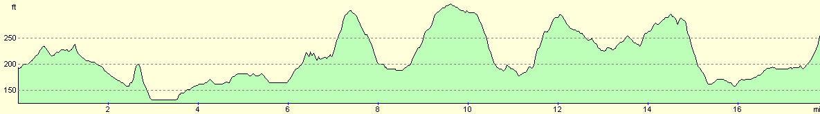
For more information on profiles, ascents and descents, see this page
Transport
There are regular train services between Hitchin and Royston, calling at several stations between them, including Letchworth and Baldock.
Disclaimer
Please note that I take no responsibility for anything that may happen when following these directions. If you intend to follow this route, then please use the relevant maps and check the route out before you go out. As always when walking, use common sense and you should be fine.
If you find any information on any of these routes that is inaccurate, or you wish to add anything, then please email me.
All images on this site are © of the author. Any reproduction, retransmissions, or republication of all or part of any document found on this site is expressly prohibited, unless the author has explicitly granted its prior written consent to so reproduce, retransmit, or republish the material. All other rights reserved.
Although this site includes links providing convenient direct access to other Internet sites, I do not endorse, approve, certify or make warranties or representations as to the accuracy of the information on these sites.
And finally, enjoy your walking!
Nearby walks
| # | Title | Walk length (miles) |
|---|---|---|
| 96 | Great Chesterford to Royston | 16.6 |
| 120 | St Neots to Biggleswade | 13.0 |
| 122 | Biggleswade to Hitchin | 11.6 |
|
|

|