Walk #245: Barton-Upon-Humber to Pyewipe
 |
 |
|
General Data
| Date Walked | 24/10/2002 |
| County | Humberside |
| Start Location | Barton-Upon-Humber |
| End Location | Pyewipe |
| Start time | 08.10 |
| End time | 16.55 |
| Distance | 23.7 miles |
| Description | This was a long and entertaining walk, mainly following the sea defences of the River Humber aside from an inland diversion around Immingham Docks. |
| Pack | Today I carried my 30-litre Karrimor HotRock rucksack, which was filled with my packed lunch, waterproof coat, water bottle and a couple of spare shirts, together with the usual assortment of odds and ends. |
| Condition | I am more or less fine after this walk, and could easily have walked further (indeed, I had intentions to do just that). The only downside is that I have a hotspot on the ball of my left foot, which if I am not careful may turn into a blister. When I met Sam in the early afternoon I changed from my boots into my old pair of trainers, which seems to ease the formation of the blister. |
| Weather | Today's weather was lovely, with a mostly sunny sky with patchy cloud overhead. It was quite warm, and the wind had eased from yesterday. There was no sign of any rain, although Sam says that there had been a shower of drizzle where she was. |
| OS map | Landranger number 107 (Kingston upon Hull & surrounding area) and Landranger number 113 (Grimsby, Louth & Market Rasen) |
 |
 |
|
 |
Map of the walk
Maps courtesy of Google Maps. Route for indicative purposes only, and may have been plotted after the walk. Please let me have comments on what you think of this new format. For a detailed table of timings for this walk, please see the table file.
Notes
This was a long walk that should by rights have tired me out; however when Sam picked me up at the end I could easily have walked much further if the need had arisen and I was even considering walking on into Grimsby. However when I phoned her Sam was already on the way to pick me up, and so it was with some reluctance that I stopped the walk a mile or two short of that goal. Considering the long distance that I have done today I feel remarkably fit; I have no real problems and I do not feel as fatigued as I have on previous walks half this length. Today's walks was flat, which helps, but mainly I think that I am getting used to the day after day walking, and if the weather is nice my mindset is just to keep plodding on.
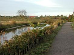
I set off from the campsite eager to get on, and a short stroll up the road took me to Barton-upon-Humber. I was quite keen to see who was the celebrity involved in the Ulrika Johnson rape case, and so I nipped into a paper shop to have a look at the relative front page. The whole thing intrigues and slightly sickens me - whoever it is will have a trial by media (that much is obvious already), and I doubt that the truth will come out, or that any damage to either party will be repaired by what is going on. Strangely depressed by all this, I started on down a track that led to the site of the old brickworks, still present on my map circa 1999, but now being landscaped into a wildlife park. This is where the first problem of the day occurred - I could not find the path that led out of the brickworks and to the foreshore, and ended up wandering about a series of small lakes, a legacy of the clay pits. Eventually I found my way out to a road to the south of the pits, and I then walked down a track to again access to the riverside footpath.
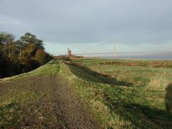
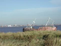
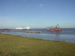
A little diversion up the aptly-named 'The Beck' stream, complete with a couple of families of swans, took me to the site of Barrow Haven Station, and half an hour later I found myself in New Holland. This was a very busy area, and I passed a large pier with a ship unloading at it before turning inland to walk through a factory to gain access to the riverbank on the eastern side. By another little jetty there was a few barges being broken up (or rusting away, more accurately), and a little further east there was a trawler beached and also rusting away. All the ships rotting made me feel strangely sad, and only the sight of yet more flotillas of swans made me any happier. The views across the Humber to Hull were quite nice, and I could make out the places that I walked past yesterday. I could also look back along the river to the Humber Bridge for a long time, eventually only losing sight of it when I turned the corner to head southeastwards at Skitter Ness.
I had a little rest at East Halton Skitter, sitting on the flood bank by the bridge over East Halton Beck, which was quite a quiet little spot. From there I followed a concrete road behind the seawall as it headed southeastwards, passing the chimney of an old brickworks before reaching the oil terminal jetty at North Killingholme Haven, which marked the start of a fairly dreary stretch of walk past Killingholme Marshes. At South Killingholme Haven the riverside path ended, and I was forced to divert inland to walk along the A160 instead, a long and boring road walk around Immingham Dock. I was tempted to see if I could gain access to walk through the docks, but after a little consideration I decided that it was pointless - I have not been allowed into any of the other docks that I have passed, and it is not worth trying to trespass, only to be told off.
Sam drove past me on the dual carriageway stretch near Houlton's Covert, and she pulled up in a lay-by. I entered Mervan for a chat, to change into my trainers and to replenish my water bottle, which was low. The road walk was quite boring, and I was glad when I reached the footpath that led back to the seawall on the southeastern side of Immingham Dock. The concrete road that I had been following on the other side of the docks continued on this side, and it allowed me to make good speed southeastwards, past a car that contained a courting couple. On the outskirts of Pyewipe the path diverted back inland past a large factory, but there were mechanical diggers on the path - the factory was being extended, and a new footpath was being created a couple of hundred yards to the west. After asking permission I was allowed through on the old path, past some lorries busy moving earth. Once I reached the public road I turned to the left down another road that headed eastwards past a power station. Sam was waiting for me at a roundabout, where I was glad to end the day's walk.
Directions
This walk starts off at the Silver Birches Tourist Park on Waterside Road in Barton upon Humber. Leave the caravan park and turn right to head south for a little under a kilometre until just before the railway station is reached, when you turn left down a road. Follow this road as it curves around to the left to head northwards for a kilometre until it ends at a park by the river at Barton Riverside. Here I walked diagonally through the park to reach a gate that leads out onto a public road near the railway line, although there is a footpath that is marked on the map that runs alongside the river, which should be an easier walk. Once on the road follow it eastwards and just before it meets the railway line, turn left down a track that takes you north past some flooded clay pits on onto the riverbank. Turn right and follow the river bank eastwards for a couple of kilometres until you reach The Beck; here the path follows the western bank of The Beck south for a few hundred yards until a footbridge over the beck is reached, beside the rail bridge.
On the other side turn left and follow the flood banking as it continues eastwards alongside the river for another couple of kilometres until it nears the pier at New Holland. Just before the pier is reached the footpath leaves the flood bank by turning to the right down a track for a couple of hundred yards towards the railway line. The track then turns to the left and follows the railway line for a short distance towards a level crossing and the end of the B1206 road. At the road turn left to head north for a hundred yards, and then turn right to head through a little area of dockland before reaching the flood banking once more. Follow the footpath that runs along the top of the flood bank to Skitter Ness, where it turns to head southeastwards beside the river.
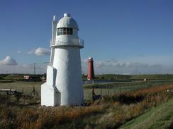
At East Halton Skitter cross the bridge over East Halton Beck, and then join a track that runs along the top of the seawall. After a couple of miles the pier at North Killingholme Haven is reached; follow the footpath as it diverts inland slightly before rejoining the seawall on the southeastern side of the pier. Continue on southeastwards past the two Killingholme lighthouses until South Killingholme Haven is reached; here the seawall can no longer be followed, so turn right and follow the track as it heads southwestwards through a fairly bleak industrial landscape to reach a roundabout at the end of the A160 road. Continue straight on at the roundabout and follow the A160 as it passes under a railway line and ends at a roundabout with the A1173 road. Turn left and follow the A1173 road southeastwards for a couple of miles until another roundabout is reached to the northeast of Immingham.
At this roundabout turn left and follow the road as it curves around in a northeasterly direction. Shortly after the road passes over a railway line it ends at an entrance to the docks; here turn right down a minor road, and after a few hundred yards turn left down a footpath that runs northeastwards along the edge of some woodland to the seawall once more. Turn right and follow the footpath that runs along the top of the seawall southeastwards past a series of factories and a power station until some factories at Pyewipe are reached. Here the footpath leaves the seawall and turns to the right to head south along a track past the factory for a little under a kilometre until a toad is reached. At the road turn to the left to walk eastwards for a little under a mile until a roundabout is reached at grid reference TA258110, where this walk ends.
Distances
| From | To | Distance (m) | Ascent (ft) | Descent (ft) |
|---|---|---|---|---|
| Barton-Upon-Humber | East Halton Skitter | 10.3 | 115 | 115 |
| East Halton Skitter | Pyewipe | 13.4 | 164 | 157 |
This makes a total distance of 23.7 miles, with 279 feet of ascent and 272 feet of descent.
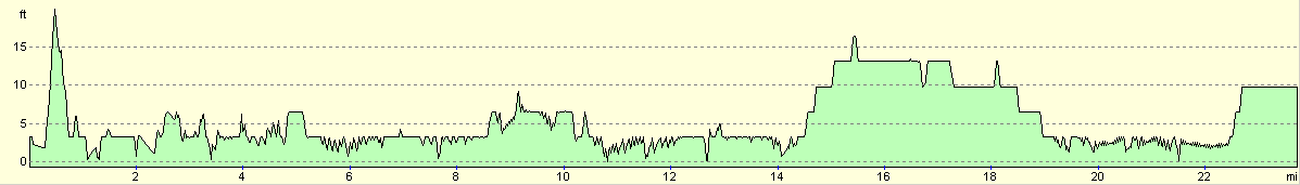
For more information on profiles, ascents and descents, see this page
Accommodation
We stayed at Thorpe Park, Humberston, telephone 01472 813395. This campsite cost us fifteen pounds for the night, and from our experiences this was terrible value. We got put up on an upper, grassy area, which was slightly boggy, as we had been told that the lower area was full. When we got there we could see that it was far from full. We also had to pay a ten-pound deposit for the key, which does seem rather excessive. When we got to the upper fiend and et up we checked out the facilities, and whilst the ladies in one of the two blocks opened with no problems, all the other doors were bolted shut. We therefore had to walk down to reception, to be told that the toilet blocks in the upper field were shut for the winter and that we would have to use the lower ones. This involved a not insignificant walk, and it turns out that to get into these we needed a pass card rather than a key. My honest opinion is that if a site wishes to get the money from a field, than all the facilities on that field ought to be open for as long as people are there - doing otherwise is not giving people what they pay for. So far on this trip it seems as though the large sites are the ones that we have the most trouble with; the smaller sites are generally operated by their owners and not seasonal paid staff and are therefore more inclined to give the visitors what they paid for. I would most certainly not recommend this site to anyone.
Disclaimer
Please note that I take no responsibility for anything that may happen when following these directions. If you intend to follow this route, then please use the relevant maps and check the route out before you go out. As always when walking, use common sense and you should be fine.
If you find any information on any of these routes that is inaccurate, or you wish to add anything, then please email me.
All images on this site are © of the author. Any reproduction, retransmissions, or republication of all or part of any document found on this site is expressly prohibited, unless the author has explicitly granted its prior written consent to so reproduce, retransmit, or republish the material. All other rights reserved.
Although this site includes links providing convenient direct access to other Internet sites, I do not endorse, approve, certify or make warranties or representations as to the accuracy of the information on these sites.
And finally, enjoy your walking!
This walk was mentioned in the following routes:
| My walk around the coastline of Britain |
Nearby walks
| # | Title | Walk length (miles) |
|---|---|---|
| 243 | Skeffling to Paull | 18.9 |
| 244 | Paull to Barton-Upon-Humber | 15.7 |
| 246 | Pyewipe to North Somercotes via Grimsby and Cleethorpes | 18.8 |
|
|

|