Walk #317: A circular walk around the Isle of Portland
 |
 |
|
General Data
| Date Walked | 05/01/2003 |
| County | Dorset |
| Start Location | Wyke Regis |
| End Location | Wyke Regis |
| Start time | 08.12 |
| End time | 13.54 |
| Distance | 13.3 miles |
| Description | This was a highly enjoyable and varied walk, with some great views being available from the high cliffs of the island. |
| Pack | Today I carried my 30-litre Karrimor HotRock rucksack, which was filled with my packed lunch, waterproof leggings, water bottle and a couple of spare shirts, together with the usual assortment of odds and ends. |
| Condition | I feel absolutely fine after this walk, and have no problems to report. I could easily have walked further, but there would have been nowhere convenient for Sam to pick me up if I had done so. This is another day where I had no trouble with my ankle, which makes me feel quite happy. |
| Weather | The weather today was cold but sunny, with some absolutely lovely sunny skies uplifting my spirit as much as the cold dampened them. In high exposed places the wind made it distinctly chilly, but for the majority of the time I was sheltered from it and I was not too cold. |
| OS map | Landranger number 194 (Dorchester & Weymouth, Cerne Abbas & Bere Regis) |
 |
 |
|
 |
 |
|
Map of the walk
Maps courtesy of Google Maps. Route for indicative purposes only, and may have been plotted after the walk. Please let me have comments on what you think of this new format. For a detailed table of timings for this walk, please see the table file.
 |
Notes
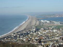
This walk was not on my original schedule and I only decided to do it last night, and I feel as though I must explain why I did it. Yesterday a lady told me how lovely the walk was, and how superb the views over Chesil Beach are from above. Having done the walk I am thoroughly glad that I did, as the view over the beach from the tops of the cliffs was quite fantastic.
This does mean that for the first time on this walk I have ended a day exactly where I started it, which is a really strange feeling. I am used to making progress and to be able to see on a map how far I have moved, yet today I have essentially not moved at all. It also means that the scripts that create my website may need alteration to cope with this; I will not be able to do this until the next time we have mains power to Mervan. Doing this work could well take some time, as I do not believe that I designed the scripts to cope with this sort of walk, which shows a distinct lack of forethought on my part.
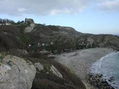
There seems to be some debate about whether the walk around the island is part of the South West Coast Path or not. My guidebook for this section of the walk (published in 2002) does not mention it, but the South West Coast Path Association Guidebook 2000 gives directions and states that it may soon be part of the path. There were some South West Coast Path signs on the route, and some signposts had the National Trail Acorn symbols put on them. I would guess that the Isle is slowly becoming part of the route of the South West Coast Path, but that work is ongoing. In particular it is a shame that the route does not explore the northeastern section of the island more - it turns westwards by the prison and misses that part of he island completely.
This walk was unusual for another reason - it is the first time on this walk that I have walked with the sea on my right. I did this for two reasons; firstly the directions in the South West Coast Path Association Guidebook are printed that way around; and secondly I wanted to get the views over Chesil Beach from the high cliffs on the western side of the island. I felt that I could get away with doing it anti-clockwise as this walk was not officially part of my walk, and I can therefore choose to do it in whatever direction I want.
After I finished the walk we decided to go into Weymouth and visit the cinema so that we could see the latest Lord of the Rings film. We both really enjoyed the film, and it made a great change from being stuck in the van all evening. We had an hour to wait before the film began, so we went into a pub beside the cinema to while away the time before it started. The film itself was excellent - although it does vary from the books on a few places (and would need to given the epic length of the books) you really did not notice this too much as it was packed with so much action.
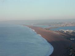
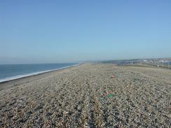
Chesil Beach is very impressive - the view of the massive shingle bank from the cliffs on the Isle was truly stunning, particularly with the red early-morning sun shining onto it. I had seen photographs of the beach before, but it was only when I was standing beside it that I got the true scale of it as it towered above me. On the way back to the van at Wyke Regis I diverted onto the beach for a short distance, but the stones at this eastern end of the beach were reasonably large and well-rounded, which made walking on it quite difficult and slow, so I soon reverted to walking back along the road.
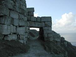
The Isle is famous for the quarries of Portland Stone that for years was it's greatest export. The north-western side of the Isle is littered with old quarries, and the path passed through some of these. Portland Stone was used in many great buildings both in Britain and abroad, including St Paul's Cathedral, Buckingham Palace and the Tower of London, and also the United Nations headquarters in New York. At least one quarry is still active on a smaller scale, and this led me to wonder where the newly-quarried stone is being used.
There are two prisons on the island, both based at its northern end. There is a Young Offenders Institution and a very foreboding adult prison, which is based in the old Verne Citadel. This is entered across a bridge over a deep trench and then through a tunnel, and houses 575 men in medium security accommodation. The Citadel was built by convicts between 1860 and 1872, and from 1949 it was used by the prison service to house prisoners. The outside of the building - which is actually more of a part of the landscape than a building - looks almost impregnable, which is not surprising given the use it was built for.
Directions
| During this walk I followed the South West Coast Path, the route of which is detailed in the Ordnance Survey National Trail Guide 11, Exmouth to Poole (ISBN 1-854109-88-X). Unfortunately the route description is written in reverse to the direction that I am walking, but the 1:25,000 maps in the book are clear and the signs on the ground are very good. Also to be recommended is the South West Coast Path Association guidebook (ISBN 0-907055-04-4), which has less concise directions and no maps but does include accommodation details and grades each section of the walk according to difficulty. They also publish reverse directions, which are suitable for walking in the direction that I walked the route. They have a website at www.swcp.org.uk, which is well worth a visit. | 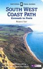
|
| 
| |
| |
| |
The route for this walk was detailed in the South West Coast Path Association guidebook, which has some reasonable directions but no maps. There were some national trail signs on the route, and navigation was simple using the 1:50,000 map and the signs.
Distances
| From | To | Distance (m) | Ascent (ft) | Descent (ft) |
|---|---|---|---|---|
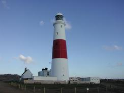
| Wyke Regis | Portland Bill | 5.7 | 791 | 794 |
| Portland Bill | Wyke Regis | 7.6 | 879 | 876 |
This makes a total distance of 13.3 miles, with 1670 feet of ascent and 1670 feet of descent.
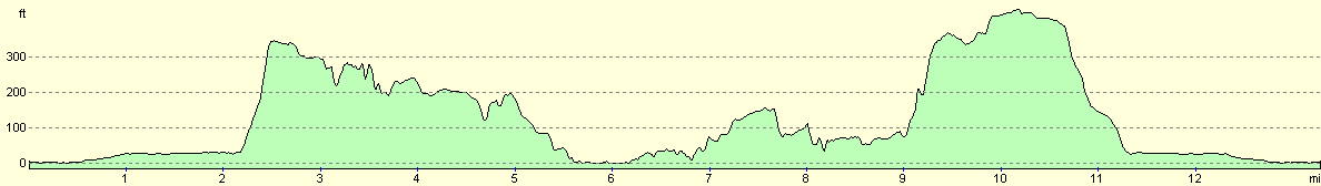
For more information on profiles, ascents and descents, see this page
Accommodation
We parked in the car park at the Ferry Bridge Inn in Wyke Regis, who allowed us to stay in their car park free of charge, which was kind of them.
Disclaimer
Please note that I take no responsibility for anything that may happen when following these directions. If you intend to follow this route, then please use the relevant maps and check the route out before you go out. As always when walking, use common sense and you should be fine.
If you find any information on any of these routes that is inaccurate, or you wish to add anything, then please email me.
All images on this site are © of the author. Any reproduction, retransmissions, or republication of all or part of any document found on this site is expressly prohibited, unless the author has explicitly granted its prior written consent to so reproduce, retransmit, or republish the material. All other rights reserved.
Although this site includes links providing convenient direct access to other Internet sites, I do not endorse, approve, certify or make warranties or representations as to the accuracy of the information on these sites.
And finally, enjoy your walking!
This walk was mentioned in the following routes:
| My walk around the coastline of Britain |
| South West Coast Path |
Nearby walks
| # | Title | Walk length (miles) |
|---|---|---|
| 316 | Lulworth Cove to Wyke Regis | 13.7 |
| 318 | Wyke Regis to West Bexington | 14.3 |
| 814 | Lulworth to Weymouth | 12.2 |
|
|

|