Walk #357: Bude to Hartland Quay
 |
 |
|
General Data
| Date Walked | 15/02/2003 |
| County | Cornwall, Devon |
| Start Location | Crooklets |
| End Location | Hartland Quay |
| Start time | 08.12 |
| End time | 15.25 |
| Distance | 13.4 miles |
| Description | This is a quite strenuous walk, but one where all of the effort expended is well rewarded with some fantastic views. |
| Pack | Today I carried my 30-litre Karrimor HotRock rucksack, which was filled with my packed lunch, waterproof leggings, water bottle and a couple of spare shirts, together with the usual assortment of odds and ends. |
| Condition | The only slight problem that I had on this walk was with both of my knees, which ached occasionally when going up and down the hills. Aside from this minor niggle I had no other problems, and could easily have walked further if required. |
| Weather | The weather today was very nice, and almost exactly a repeat of yesterday's, with bright sunshine and little, if any, cloud to be seen in the sky. The easterly wind was bitterly cold, and although it warmed up later in the day first thing this morning the heaviest frost that I have seen so far on this trip was heavy on the ground. |
| OS map | Landranger number 190 (Bude, Clovelly & surrounding area) |
 |
 |
|
 |
 |
|
Map of the walk
Maps courtesy of Google Maps. Route for indicative purposes only, and may have been plotted after the walk. Please let me have comments on what you think of this new format. For a detailed table of timings for this walk, please see the table file.
 |
 |
|
 |
 |
|
Notes
This was a highly pleasing walk, and one that I am glad to say that I completed with very few problems. It has been described to me as the hardest day on the whole coast path, but I actually seemed to find it easier than yesterday's walk between Boscastle and Bude. The day simply flew by, and by the time I reached the border between Cornwall and Devon I was surprised by how quickly I got there, and how fit I felt. I am quite glad in a way to have reached that border, as although I found Cornwall to be very nice, I had spent thirty-five days in the county and was eager to sample the delights of Devon once again. It is strange to think that I have been in Cornwall for longer than the time it took me to get from Edinburgh all the way down to Sheringham in Norfolk. In total I have walked over 400 miles in Cornwall, which is the biggest distance I have walked in any county to date.
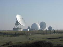
From Bude I could see the white satellite dishes on the skyline to the north that mark a major satellite uplink station for the Composite Signals Organisation. These dishes are truly massive, and dominate the view for many miles around. They are also very well guarded, with high double fences, searchlights and cameras, so much so that it led me to wonder how many people would really want to get into the place. It had by far more protective fences around it than any military camp that I have passed so far on the trip. The really funny point about the place is that it is not marked on any maps - on my 1-25,000 map it is marked as Cleave Camp, and has a few small buildings on it, and on the 1-50,000 map it is just a plain area. This would be fair enough except for the fact that the dishes are so highly visible - what is the point in keeping them off the maps?
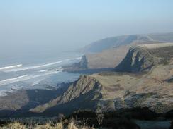
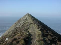
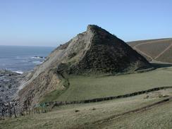
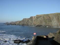
I was amazed by Higher Sharpnose Point - this is a prominent ridge of rock that protrudes a short distance out to sea, and has a narrow path running along the top of it. The views from the point were good, but would have been better if the sky had not been so hazy. The end of the nose was quite exposed and the wind was quite chilly so I did not stay too long, but it was well worth the walk, although it would not be for anyone who is scared of heights.
Just above the Devon / Cornwall border I came across Ronald Duncan's hut. This was a hut that the author and poet Ronald Duncan built so that he could write whilst looking out on the tremendous views over the sea. Not one to look a gift horse in the mouth, I went into the hut and sat down at the table so that I could eat in relative comfort. As I ate I admire the views over the sea and read the guest book. I have a fondness for reading the entries in the guest books that you find in huts or bothies, as usually amongst some fairly inane entries you can find some absolute gems. There were a few good ones in this book, and I also found Tom Isaac's entry from a few weeks before.
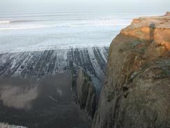
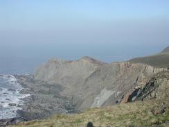
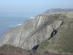
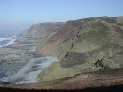
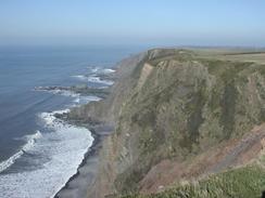
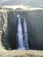
As was the case yesterday the geology of today's walk was very impressive, with the folded rock strata clearly visible where the sea had cut into it to form the cliffs. This same geology had probably led to the formation of the numerous steep-sided valleys that I had to cross, and to the formation of the waterfalls - especially the one at Speke's Mill Mouth, which was an absolutely superb example. Before I reached Speke's Mill Mouth I had to go down the flank of Swansford Hill, and this involved an interesting walk along a very narrow path with a sheer drop down the cliffs to the left. The National Trail avoids the hill and goes along the valley on the landward side, but I could see a footpath along the crest of the hill - a more coastal route - and therefore decided to walk that instead. As I got near to the bottom of the hill I could see a bunch of boys and a video camera on a tripod, and as I approached I could watch them launch themselves with breakneck daring down the steep side of one of the lesser hills. They were riding on what seemed to be a widened four-wheel skateboard, and it looked as though they were very much enjoying themselves, although you would not catch me throwing myself down hills on a skateboard!
After I left Speke's Mill Mouth I was climbing up the little hill when I met Sam at the top, who had walked the short distance from Hartland Quay to meet me. We then walked back together, and chatted to many people we met on the way. Eventually we reached Hartland Quay, and in glorious sunshine we walked down the coast path to the pub, which was fortunately open. In the pub there was a man who had been in a campervan I had sat in front of yesterday at Widemouth Bay when I had eaten my lunch - he recognised me as soon as I walked in the door, which surprised me somewhat. As I sat in the pub I was in two minds whether or not to continue on to Hartland Point or not - doing this would have extended the walk by a little under three miles, but also have made it possible to get to Westward Ho! tomorrow. As I sat slowly sipping my pint I decided against it, and instead we drove to the campsite so that I could start work on the computer.
Tomorrow I shall have complete the walk northwards to Hartland Point, and from there go to Clovelly and beyond. This puts me in a slightly difficult situation, as to walk on to Westward Ho! would lead to a twenty mile day, which is probably a bit much over this sort of terrain at this time of year. Instead I may walk on past Clovelly until I find a convenient place for Sam to pick me up, which may be at Buck's Mills or may be even Horn's Cross, although the latter will involve me walking inland.
 |
Directions
| During this walk I followed the South West Coast Path, the route of which is detailed in the Ordnance Survey National Trail Guide 8, Minehead to Padstow (ISBN 1-85410-774-7). Unfortunately the route description is written in reverse to the direction that I am walking, but the 1:25,000 maps in the book are clear and the signs on the ground are very good. Also to be recommended is the South West Coast Path Association guidebook (ISBN 0-907055-04-4), which has less concise directions and no maps, but includes accommodation details and grades each section of the walk according to difficulty. They also publish reverse directions, which are suitable for walking in the direction that I walked the route. They have a website at www.swcp.org.uk, which is well worth a visit. | 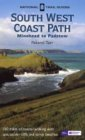
|
| 
| |
| |
| |
Distances
| From | To | Distance (m) | Ascent (ft) | Descent (ft) |
|---|---|---|---|---|
| Crooklets car park | Marsland Mouth | 8.0 | 2844 | 2805 |
| Marsland Mouth | Hartland Quay | 5.4 | 1716 | 1670 |
This makes a total distance of 13.4 miles, with 4560 feet of ascent and 4475 feet of descent.
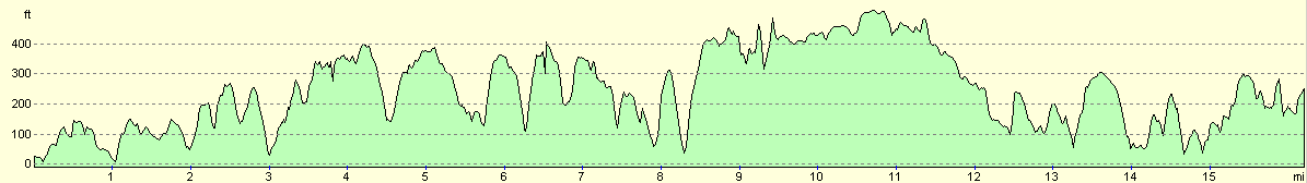
For more information on profiles, ascents and descents, see this page
Accommodation
We spent the night at Southlane Campsite, Hartland, Bideford, Devon EX39 6DC, telephone (01237) 441876 or (01237) 441242. The facilities on this site were being rebuilt during the winter season, so no showers were available so that we had to use the shower in the van. However it only cost us five pounds fifty for the night, so we cannot really complain.
Disclaimer
Please note that I take no responsibility for anything that may happen when following these directions. If you intend to follow this route, then please use the relevant maps and check the route out before you go out. As always when walking, use common sense and you should be fine.
If you find any information on any of these routes that is inaccurate, or you wish to add anything, then please email me.
All images on this site are © of the author. Any reproduction, retransmissions, or republication of all or part of any document found on this site is expressly prohibited, unless the author has explicitly granted its prior written consent to so reproduce, retransmit, or republish the material. All other rights reserved.
Although this site includes links providing convenient direct access to other Internet sites, I do not endorse, approve, certify or make warranties or representations as to the accuracy of the information on these sites.
And finally, enjoy your walking!
This walk was mentioned in the following routes:
| My walk around the coastline of Britain |
| South West Coast Path |
Nearby walks
| # | Title | Walk length (miles) |
|---|---|---|
| 84 | Boscastle to Bude | 15.2 |
| 85 | Bude to Elmscott | 13.8 |
| 86 | Elmscott to Horns Cross | 15.5 |
|
|

|