Walk #363: Lynton to Bossington
 |
 |
|
General Data
| Date Walked | 21/02/2003 |
| County | Somerset, Devon |
| Start Location | Lynton |
| End Location | Bossington |
| Start time | 07.45 |
| End time | 16.09 |
| Distance | 16.2 miles |
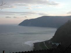
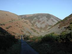
| Description | This was a quite enjoyable walk, and one that was well worth doing. Unfortunately much of it is through woodland, so opportunities for views out to sea along this dramatic stretch of coast are sadly limited. |
| Pack | Today I carried my 30-litre Karrimor HotRock rucksack, which was filled with my packed lunch, waterproof leggings, water bottle and a couple of spare shirts, together with the usual assortment of odds and ends. |
| Condition | I feel absolutely fine after this walk, as is to be expected after such a short walk. The only minor problem that I have is that the inside of my right thigh is sore for some reason, and very tender to the touch. This is more annoying than anything else, and I can easily put up with it if it continues. |
| Weather | The weather today was lovely, with some long periods of sunshine and only occasional cloud. The wind had also died down considerably, and this made for a great day's walk. There was no sign of any rain for yet another day, which really makes me wonder why I am bothering to carry my coat with me! |
| OS map | Landranger number 180 (Barnstable & Ilfracombe, Lynton & Bideford) and Landranger number 181 (Minehead & Brendon Hills, Dulverton & Tiverton) |
 |
 |
|
 |
 |
|
Map of the walk
Maps courtesy of Google Maps. Route for indicative purposes only, and may have been plotted after the walk. Please let me have comments on what you think of this new format. For a detailed table of timings for this walk, please see the table file.
 |
 |
|
 |
Notes
This was a nice and lazy days walking, and I took my time as it promised to be fairly easy terrain. I was also due to meet up with my mum and dad this evening, and so I did not want to exhert or tire myself out too much before I met them. Sam walked down the hill into Lynmouth with me so that we could have a quick look around. As we crossed the footbridge over the River Lyn we saw a hotel with a sign advertising Devonshire cream teas. All the time that we had been in Devon we had been talking about having a Devonshire cream tea, and we had never actually got around to it. Since this was going to be my last day in Devon, we decided to nip in and treat ourselves to the taste sensation that is a Devonshire cream tea. The owner of the hotel remarked that this was the first time that anyone had asked for a cream tea so early in the morning, and it must be said that having a cream tea at a few minutes past eight in the morning is indeed a strange exerience!
As I was walking eastwards along the coast from Foreland Point I could hear a couple of helicopters fluttering about below me on the cliffs. Through gaps in the trees I could see the - they appeared to be grey - as they flew around the whole area, sometimes very close to the cliffs. They ere joined by at least one fast jet, and this flew very close to the cliffs and the helicopters. I found all this extremely intriguing, and I wonder exactly what they were up to.
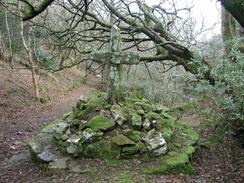
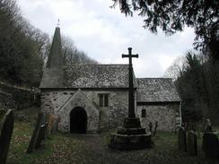
As I was approaching Culbone Church I was very surprised to see Sam waiting for me on the path. She had walked up to meet me, and we walked back together to have a look at the church. This is a fantastic little church, and is purported to be the smallest complete church in England, and is literally situated slap-bang in the middle of nowhere. We met a family out for a little walk beside the church, and we looked around the place together before heading back down the two miles into Porlock Weir. I only had a few more miles to do today, so we went to the Ship Inn in the village to have a drink before going back into Mervan to eat our lunch.
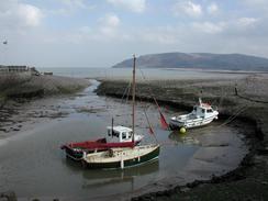
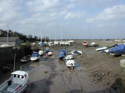
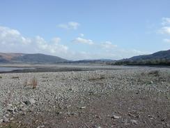
I took my time walking the last section between Porlock Weir and Bossington, and I extended the walk by walking to the breach in the shingle bank to see if it was possible to cross it. Unfortunately it was not, as there was a deep channel through the clay with a fast-running stream in it. I decided that crossing it would be silly; I walked back and took the diversion route across the marshes. In the middle of the marshes I had a phone call from BBC Radio Bath and Somerset, and I sat down on an old wall whilst I gave the ten minute slot - it was a very good interview, and they want to talk to me every weekday until I leave their area.
When I reached the car park in Bossington I as very surprised to see my mum waiting for me outside the van. I had known that my mum and dad were in the area and I was expecting to meet up with them later in the evening, but it was a wonderful surprise to see them there at the end of the walk. To make things even better, they had brought with them a couple of Birds pork pies for us, and these made for a wonderful evening meal for the two of us. It is the first time that I have seen my parents since before I started the walk, and it is great to see them looking so well.
Tomorrow I have another radio interview at about eight thirty in the morning, and afterwards I am going to be meeting mum and dad on top of Selworthy Beacon before walking down into Minehead. Minehead is the end of the South West Coast Path, and it will feel strange to have reached the end after seven weeks of walking along it, as I have really enjoyed following this trail. From now on I am going to have to devise my own routes around the coast, at least until I reach the Pembrokeshire Coast Path.
Directions
| During this walk I followed the South West Coast Path, the route of which is detailed in the Ordnance Survey National Trail Guide 8, Minehead to Padstow (ISBN 1-85410-774-7). Unfortunately the route description is written in reverse to the direction that I am walking, but the 1:25,000 maps in the book are clear and the signs on the ground are very good. Also to be recommended is the South West Coast Path Association guidebook (ISBN 0-907055-04-4), which has less concise directions and no maps, but includes accommodation details and grades each section of the walk according to difficulty. They also publish reverse directions, which are suitable for walking in the direction that I walked the route. They have a website at www.swcp.org.uk, which is well worth a visit. | 
|
| 
| |
| |
| |
Distances
| From | To | Distance (m) | Ascent (ft) | Descent (ft) |
|---|---|---|---|---|
| Lynton | Porlock Weir | 12.0 | 4154 | 4295 |
| Porlock Weir | Bossington | 4.2 | 243 | 217 |
This makes a total distance of 16.2 miles, with 4397 feet of ascent and 4512 feet of descent.
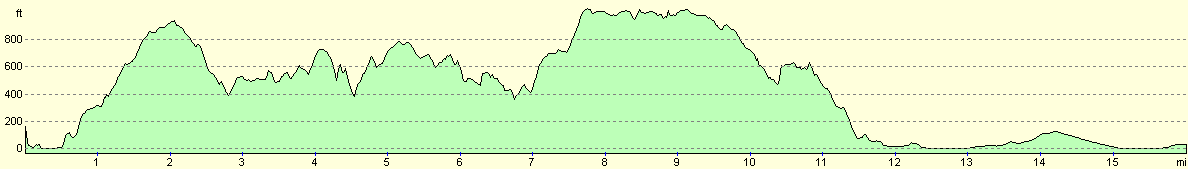
For more information on profiles, ascents and descents, see this page
Accommodation
We parked in a handy little car park in Porlock Weir, which was very handy for the local facilities. We could have parked at the car park in Bossington, but we needed to move anyway to go shopping, and for some strange reason it made sense to park opposite a pub!
Disclaimer
Please note that I take no responsibility for anything that may happen when following these directions. If you intend to follow this route, then please use the relevant maps and check the route out before you go out. As always when walking, use common sense and you should be fine.
If you find any information on any of these routes that is inaccurate, or you wish to add anything, then please email me.
All images on this site are © of the author. Any reproduction, retransmissions, or republication of all or part of any document found on this site is expressly prohibited, unless the author has explicitly granted its prior written consent to so reproduce, retransmit, or republish the material. All other rights reserved.
Although this site includes links providing convenient direct access to other Internet sites, I do not endorse, approve, certify or make warranties or representations as to the accuracy of the information on these sites.
And finally, enjoy your walking!
This walk was mentioned in the following routes:
| My walk around the coastline of Britain |
| South West Coast Path |
Nearby walks
| # | Title | Walk length (miles) |
|---|---|---|
| 90 | Combe Martin to Lynton | 13.6 |
| 91 | Lynton to Porlock Weir | 13 |
| 92 | Porlock Weir to Blue Anchor | 14.8 |
|
|

|